

Typhoon Tip
-
Posts
44,565 -
Joined
-
Last visited
Content Type
Profiles
Blogs
Forums
American Weather
Media Demo
Store
Gallery
Everything posted by Typhoon Tip
-
Occasional Thoughts on Climate Change
Typhoon Tip replied to donsutherland1's topic in Climate Change
If one wants to spend as much time and energy drafting a response like that which you did or I imagined borrowed, it is probably unwise to begin with that particular sentence right there. Lol - just a suggestion. At least not if one actually expects the target reader to engage. -
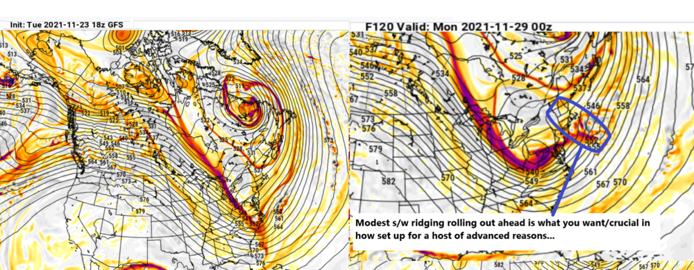
00Z GFS does something similar the following Sunday, too.
-
Way behind various product suites this morning ( apparently there was a Euro outage ? I haven't drilled back in the thread but evidence is what it is... ) Interestingly ... Golden Gate hasn't update GFS since 00z 22nd ... it's a personal go-to, but Pivotal sourcing is admittedly superior in a few ways: Noting the abrupt improvement at 500 mb re 120 -140 hours re the GFS operational. GGEM ( fw it is or isn't w ) seems to reasonably mimic this sort of potency, both now ending up plunking down an strong packet of vorticity and governing S/W field right into Pa. The right panel next interval then sends a mid/u/a wind max along the climo pathways ... S of LI. Usually...circulating mid levels impose a frontogenic force beneath... in the 5 deg lat smear extending N, regardless of whatever model in question is QPF'ing the layout. LOL .. this may be a waste of time seeing as this is less full suite comprehensive ...we'll see, but I like what I see so far for the snow enthusiasts. The other aspect is that Pivotals isohypses intervals are 3 dam ... so, I have to pull my enthusiasm in and realize that is a middling amplitude trying to quasi cut off as that bundle of joy carves underneath - but "carves underneath" [enter gloss eyed physics here] has a way of maximizing matters, nonetheless, and produce/ "over perform" sometimes, too.
-
It’ll bomb with radar scratching beaches
-
While we're considering GGEM eye-candy.... ho man, it would be fun for pop-corn sake to cinema that run out to D13 because that D10 is setting up a big time mess from the central Plains to SNE if extrapolated. I mean... just funnin' and such
-
Actually ..the 00z Euro evolution was more impressive through D6 .. beyond ? not so much. Scoots seaward and doesn't amplify further. This run 12z is less so through D6 additional to that imho -
-
I'd also caution/note, the only thing preventing the 00z operational Euro from doing something similar was it's hurried abandonment/collapse of the NAO wave space argument in the 24 hours preceding. I have looked at the UKMET/GGEM handling of that specific exertion, but ... they may be getting to their solutions erroneously either way - of course. But, when I saw hour 144 off the oper. run I almost gulped form I-95, PHL-PWM ... but then suddenly... the whole axis shifts E - it appeared to me that the sudden collapse out NE of NS/NF in the lower Maritime of Canada may allow the wave -spacing to open up. Doesn't help there's a huge kicker up over MT by D7 but I think that feature suffers from Euro's amplitude wash it applies out in that range as a weird tendency -
-
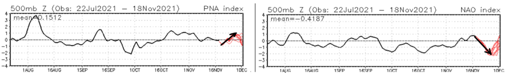
I wouldn't be tossing anything in this volatile pattern. And by volatile, ...not so much the embedded features and handling - per se - but the determinism is whack right now, big time. The PNA is transiently bubble sorting its self out around camel hump that ends up going back neg head ( but will probably fail to some degree ) out there around Dec 7. Meanwhile, the NAO mirrors around similar timing. Those mass-field yo-yo impose exertion on the flow for/feed-back from embedded features, but the models exert on themselves with huge error proneness in that emerges from handling - I mean the models are much better than circa ...2002 .. But, almost as a comical plot by a super agency ( muah hahahaha ) the planetary system is in CC turmoil ...featuring among other charms... tendencies for fast flow. Those are notoriously bad regardless of era - including now. This is +PNA is not huge N-S in stature, but does carry potency in S/W intervals to help add to space and momentum complexity. Kind of has some 'unmanned firehose' aspects to it.
-
Probably because there's a lot of destructive wave spacing/interference ... That dig into the MA also looks like it comes from typical Euro tendency to arbitrarily apply amplitude on D5+'s. It may be entirely true that something comes of that time frame, but there are plenty of reasons to be leery of that thing. Aside, the details of the QPF charts show most of that misses E by a narrow margin ( as is..)
-
GGEM trending ... fwiw -
-
Subtleties in the runs offer a lean back to a more chillier regime after perhaps a two or three days of con attempts. Lol - we'll see. Looking at individual GEF members from 00z cycle and matching with the EPS mean for H500 mb anomalies, as well as sfc pressure synoptic evolution... the only aspect limiting significant MA/NE/ NW Atl cyclogen is the lower troposhere is out of phase. Still, next Saturday looks like a nasty wintry day, with gray grits in the air and probably a siggy upslope/terrain enhanced snow squally regime for central/NNE. It's pretty well agreed upon in both the GEFs and EPS means. Hey.. winter appeal is what it is Not sure I buy this recent 12z wild windy deep cold noreaster for Dec 2 just yet. But... you know, ...the suggestion from the telecon spread was always more encouraging than the operational runs of any model - interesting... But there is still a correction tendency going on with the +PNA/-NAO ( and looking at the EPS mass fields argues any tele's from that cluster would likely match the American source - ). People need to see the significant event on the charts to be enthused. This is unfortunately a situation where the canvased potential is waiting -
-
Heh... we will, just because we don't want that - perhaps... But I have my doubts just based on trends. This was set to be a pretty siggy ( not historic perhaps, but significant nonetheless) negative departure off a -EPO loading...then PNA relay with counterbalanced -NAO for good measure. Nothing. We normal, with oscillatory behavior now through the period ... Recurring correction theme for ...7 years, hey! - that trough that looked so encouraging is now progressive because the NAO is ...doing whatever it is doing but it ain't blocking that's for f sake. It's also being f'ed around with and actually is becoming more E bias than ideal ...probably why the trough moves out. And the cold is attenuated because it didn't get the back loading of the 'phantom' -EPO... Same old same old with models picking up on signals distantly as though they are giant moons rising over the horizon only to come into coherence as some reduced semblance of their original signal. It seems just as likely to me that any adjectives describing warmth will appear equally overstated. We'll see.
-
Occasional Thoughts on Climate Change
Typhoon Tip replied to donsutherland1's topic in Climate Change
While yet there is an even better argument than that - (just ranting here ...not directing this at you ) It's call extinction mmm yeah. While we're busily divvying up the remains ... like we have a choice in the matter. No one believes that, of course. But hell, we are at least heading in the right direction. What used to at minimum be met with majority in-deference, has now made its way all the way to ' stop alarm sounding.' At least in this latter, there has to be some omission somewhere in there that there is at least a real concern. Lol It's like after 30 years of denial, we are now ready to accept, "Yeah, Okay, but it's not as bad as that ...I bet " (Psychologists refer to that as 'bargaining,' an evasive tactic that offers soothe over an otherwise painful truth - it's not real acceptance tho) The truth is ... IT IS THAT BAD. Despite all conceits and/or qualitative achievements as a species, we are really only a tick better than any other form of life form on this planet. Those "lessers" are wholly dependent on tactile registry to sense danger and motivate. We, on the other hand, are supposed to use fore-spectrum-based proactivity. It's really like we run "forecast models" that predict within errs of tolerance ... of course, what the future will be, inside our heads. You know, for all the posits there are that attempts to explain the difference between us and them ... that may be it. As the reality of language becomes better defined, it is clear that birds f'ing talk to one another - yes, that's right. Bird brains! Speaking of which, crows use tools. Or, Capuchin Monkeys use heavy rocks to crack open nuts ... so that blows the tool usage away, too. So what do we have left... the use of fire. Let's examine that for a moment: We are sentient of the future, uniquely. Taming fire really for that ability. Observance lends to working on the dynamics of the propagating system in such of way to force an outcome. That may really be our defining characteristic that separates us from all other living things on this planet: it's the ability of cause-in-effect forecast modeling that all humans are gifted with ... (some more than others, be it in punchlines or practice but there are exceptions to every rule), but only doing so along a spectrum where we are alone at this level. Yet, despite this intrinsic advantage, we are still too far in a way more willing to motivate if and only if the 'perception' of threat is being registered in: Sight, sound, smell, taste or touch. These are what move people off the train tracks - merely telling them the train is coming? They'll look up and down the track to make sure first. Global Warming and climate change's disadvantage always was that it is impossible to perceive changes in ambient temperature, when that range is mere decimals over the scope of a year's records. Therefore, we're looking up and down the proverbial tracks. GW/CC has no advocate that appeals.... Meanwhile, the chemistries of life DO respond to minute changes in nature, that are in those deceptively irrelevant scales. It's just another example of how the extraordinary evolutionary leap that brought humanity the gift of foresight and innovation forecasting, may ironical have been an arbiter of its extinction. Now that is a interesting twist... It's like the moment Arthur C. Clark's ape picked up the burning stick with a pensive connection, that was the moment the end began - and everything since is far more academic than we could ever imagine. -
Yeah agreed - this is basically the gist of my inability to keep it brief - haha.. seriously though, word. +PNA/-NAO tandem. I agree with Ray re suppression .. but, I am also seeing a tendency past D6 to 'relax' the isohypses counts from TX to the southern tip of J Bay... that helps to alleviate the negative interference should that paint reality -
-
Occasional Thoughts on Climate Change
Typhoon Tip replied to donsutherland1's topic in Climate Change
It's not going to be easy. This is essentially a species level event crisis, ... really perhaps the first legit test of the KS level 1/ 'planetary manipulation' - unforgiving exam where you failure can mean extinction. Here? - to ween a 7.5 billion-ballasted momentum, off of multi-generational adaptation to a FF matrix as primary energy extraction method? There is no easy pathway to that vision - not lecturing you per se...speaking to the strawfolk reader here... There is going to be duress at multiple scales of civility ... Could even culminate in war(s). There is probably going to be hording. The specter of dystopia may become overwhelming, causing regression tendencies. It's a race... it's quite ironic, that technological advancements got us into this mess; we are now so inextricably dependent that technological advancing has to play a pivotal role in how that race ends. Meanwhile, some ecological failures could mean food problems. Future Pandemics? get used to it. Species migration do to habitat stressing co-mingle biophagic agents where there are no defenses. Yeeah. Say, if the ocean phytoplankton C02-02 cycle crashes... pretty much anything over 50kg that requires warm blood, that doesn't have tech to make O2 the other way... can't breath. Probably we won't run out of air.. but that combined with other factors becomes insurmountable toxic cocktail. We cannot survive if X-number of species eradicate below a codependent threshold... and those that believe we can out live a mass extinction are basically Walking Dead. Any of this endless list is a dystopian Sci Fi novel - the good kind. Good because it's eerily plausible if not likely. We've been covering this in long winded prose, in this particular thread for several months at this point. Probably a bit much to read outside of cover-to-cover couch and tea engagements. Most in here are too Twit and/or quick textual in attention span - understood. The ultra short version, there are two choices for the humanity future: 1 Hardship, .. how much or little depends. It certainly can be ameliorated via cooperation, which begins at acceptance - which we are just barely now getting the mass of those that accept over the fulcrum. 2 Death Pick -
...heh, like this -NAO is attempting to do, albeit nuanced -
-
You guys are spoiled oct is not really a climo snow month in any perception, anecdotal or rational measure … when expanding back to 1980. … I don’t know if the last 15 years is quite yet enough to “count on“ snow and I certainly wouldn’t call it seasonal to have snow in October. Nov is only half over
-
Not a bad hypothesis... I think also the fact that at D4 ( 96 hours off 12z. ..) we can see the initial -NAO is pretty east based over that Islandic limb/region of the domain? Then, as the +PNA loads the trough east, there is height response over the western limb, and that more than less triggers the retrograde of the NAO blocking to reposition west by D8 or so... Across the differentiating span of time, that's kind of going with your suggestion there - I mentioned earlier, some of this forcing is emergent ... - and things materialize differently "if"/when that gets sampled
-
that's why I said at the bottom, "12z individual runs.." ?
-
It really is almost comical looking at this operational 12z Euro ... timing just has to be that much off. I mean I know some of you don't take this stuff very seriously or ... believe it's even true in some cases, but these Tend to cause these ... *NOT* that busted ravioli the 12z individual runs seemingly are parameterized, before they even run, to on-purpose ... f*ck up potential. Amazing the proficiency in which they execute nothing. LOL Yeah, such is the way though. It'd be funny if this come around to a more meaningful ordeal ...
-
It's strange ... the problem is, a -NAO drills storm track ( climate ) south through the Mid Atlantic; +NAOs are more indicative of cutters and storms going up that way/St L Seaway etc.. This? We have a strong trough ejecting through the west during at least a transient, +PNA that is in the process of materializing. That lends to some uncertainty as to how much "positive feedback" said trough might or might not get enhanced by superposition ...etc..- so there's that. But, the earlier cutter happens just before the big -NAO plunge. So, the track climo suggestion is a splitting in two across the temporal span. At the start of the period there is tendency for Lakes cutter tracks, that then fades...over the course, the opposite emerges. It's like the models are executing both plans. Very interesting for dorks with free-time I suppose..but in practical senses it's not clear to me ( anyway ...) how that latter amplitude will behave and what it will mean. I've been chiming the last couple of days not to toss that as a possible "fun" ( depending on one's point of view ) player, because these uncertainties above, deny the pragmatics of auto-dissing ... a tact that the psychosis of this engagements seems so uniquely willing to take...
-
Occasional Thoughts on Climate Change
Typhoon Tip replied to donsutherland1's topic in Climate Change
Despite the many turns of phrases ...and the protracted philosophies in excoriation, cynicism of outlook and visions of destruction that ranged into excessive lengths and thread hijacking - ha... It all boils down to, 'where there's a will, there's a way' Which concomitantly means, there's been less will to date. Things are changing ... if too slowly, okay - but there is momentum gathering in the right direction. What do we expect ...with 7.5 billion human beings, not hailing from the same perspectives on matters, ... blah blah blah, we've hammered it enough - there is a race of sorts: does the momentum gather in time - -
Uh...yeeah. Best advice? In this particular next 6 or so days, do not take any operational rendition too seriously. Not with that giant non-lineary, back-loading wave exertion in the flow. It's materializing - not already materialized . ( not you per se ... for the general run-to-run enthusiast that may run reactionary tendency. heh) But that order of operation means that event next week ...even the one after it perhaps nearing the 28th-30th .. are way way way open to interpretation and future error. Pointing out the obvious ... NAOs are notoriously poorly handled in both amplitude and spatial dimensions -...and also in time, too. We can say with far more confidence what the mode tendencies ( tho not absolute confidence ) will be. Not as much for how strong, definitely not where it will bias/anchor. It's a scatter-plot affair. No one asked me, but ... the GEFs telecon spread overnight is a robust Archembault signal...still, *but* as we know ...signals can at time come and go and sometimes don't cash in. Thing is, there is an interpretation bias there...because a big cyclone could evolve for all this ... not hit here, and people think the signal failed. WRONG. Strawman, ... perhaps you didn't get the memo but the weather is not here to entertain you specifically ... sometimes you get invited to the VIP lounge. Sometimes you don't. But the party still happens(ed) whether you are getting the lap-dances. There may be a large gyre stalling too far NE ... sure. Signal satisfied. That other poster ( can't recall whom) noted, the 'polish' of the overnight runs did come into an apparent better coherence/concerted appeal there. Agreed. If perhaps 'nuanced' in operational runs ( frankly, the Euro looks wrong to me but I may be wrong too - ha). But that GEFs cluster features now a very heavily multi-member curve-superposition there, with -2.5 SD NAO plunge ( again, where may be the biggest hurdle to determinism...). While also, the PNA membership is more coalesced around a total two SD change, from -1 to +1 ... That's a lot. And my hunch is the operational GFS and the cross-guidance look of the Euro, are both flatter than that teleconnector - ...just adds to the uncertainty. Anyway, live by the GEFs ...die by the GEFs I suppose. Same holds true for the EPS too.. I do sense though 'weight' is given to the Euro cluster. I can't say I blame folks for doing so... based on the last 20 years of technology, no. But, mmm... I think huge NAO mode change like that, considering the nature of the beast ..., may or may not manifest in guidance.
-
Ha ...funny 'acclimation relativity' perspective in play here - I mean, you step out side in this on July 10 and you're going, " f*ck this man" and grabbing a jacket.
-
Occasional Thoughts on Climate Change
Typhoon Tip replied to donsutherland1's topic in Climate Change
N/A has exhibited a warming but also offsets that have been asynchronous with the Global signal ... with cold loading specifics off the NE Pac circulation mode that is favoring mid latitudes over the continent; it is 'intuitive' to see why those regions 'might' have a cool bias relative to the whole planet.. Not sure what the total conversation facet was that led to the above exchange - or if these counterpoints were taken out of a bigger context... etc. But, I have noted in the past that since 2000 and looking at the monthly publications from NASA et al and climate watch, N/A cool pools relative to the whole have occurred some 2/3rds of the months - it's probably related to that ... interesting -


