Typhoon Tip
-
Posts
44,565 -
Joined
-
Last visited
Content Type
Profiles
Blogs
Forums
American Weather
Media Demo
Store
Gallery
Everything posted by Typhoon Tip
-
Almost get the sense looking at that, a couple few members must be emphasizing the 6th wave more so than the 8th-10th
-
That Euro solution might stall but ... you know I realize we're done with autumn's perennial boredom prison sentence and would like to move things along, the obvious applies here -
-
This ... I spoke about that aspect earlier yeah. It's like the NAO D. Straight variant eitehr retrogrades to west-central Canada, or...just decays in lieu of the latter - Either way, that is a subsume scenario as is in that lala range. But your general point is the bigger take away - in general, active stormy look may be setting up - and this time, actual cold/baroclinic physics to work with, most likely
-
Man ... purely for the entertainment of the thing, the value therein is priceless if one could see the next three days of where the GGEM solution was going with that mo'fugga.. ho man! Beyond the kingdom of Bun. That D8-9-10 --> leading is like that Jodie Foster "Contact" scene, " ... No words. only poetry "
-
Occasional Thoughts on Climate Change
Typhoon Tip replied to donsutherland1's topic in Climate Change
It's like .... this boundary "|" represents the too late line in time and history below. To the left of that line is "in time," to the right is too late. Now say "*" is the demarcation time in history when humanity actually demos any quantized compensatory practices - minimally. "sooner rather than later" presently, is unfortunately the difference between this, | * versus this, | * but is still too late and cannot mean this, * | ( I'm not yelling at you here - I'm just musing from your launch point LOL ) Yeah, it's happening but too late in either case by the 'pictorial arithmetic' above. Further take: This cannot end-well. Now … it may end 'better', but not without acceptance and execution of two phenomenon: - broad sweeping attitude and life-style redress - not sure that can happen without self-dissolving dysfunction if not wars; It is difficult if not impossible for this Gen-Xer to believe otherwise. For having been raised and suffered along side of an ambrosia in humanity-self-impose vicissitudes, a world heated by distracting pettiness ( with a smattering of worth-while problems, as well), can ever make that transition in a white-gloved way. - population correction. How much, or how this latter transpires, are irrelevant. It is an advent in human history that is going to happen, whether we control this crash -landing, or not. Or.. adios muchachos. The population aspect is a big one - perhaps the bigger of the two. Because, prospecting life style hardships, and/or reticence to adaptation when forced to change ways and means ...perhaps can be graced by technologies. Kind of cushioning that ...if (say..) electric cars were to become that much more efficient, and solarvoltaics raise its median solar irradiance --> electrical power efficiency from 26% to 60 or 70 ( say ...), and be readily manufacture-able without big oil lobbying it's infeasibility. Perhaps there is an efficiency break point where if that is achieved ... we can run the grid without any coal or oil. Supplementing with ongoing or event advances in wind and hydro ...really, these latter techs ...? There's so much there. I mean Jesus, put hydro plants at tidal gates for f-sake. That is free power until the gravitation Newtonian model of the solar system ends ... It's all right there - we have the engineering intelligence as a species to take us to, and pass entry into the realm of K-1 pedigree - I realize there is an interpretation that K 1 organizes control at stellar scales, but I believe the K-1 is actually planetary. We just have to at last see through the illusion that there are of no other means. That's happening ...slowly. Maybe too slowly. The sociopath manipulation over an intellectually incapable western population, one that was erstwhile too pacified to challenge ( not helping), big oil has divisively stymied matters over the last 40 years. Unrealistic: choose not to make more than one baby per couple. In 100 years, that would half-under the human population. 3.5 billion with future tech and measure... maybe-maybe-not enough. As an aside, consider the biomass distribution of planet Earth. The human species atones to ~ 1/10,000th of the total Terran biomass. It is difficult to census the taxa comparatively, but let's approximate using a 'conceptual short-cut' - we'll use elephants. Prior to recent human intervention practices, ...~ 100 years ago, there were ~ 10,000,000 elephants. Compared to ~ present day population of humanity at 7.5 billion, 100 years ago the viable gene pool of elephants was 0.13% of our total population. SO ...using that a better than 50% accurate ( albeit still) sloppy metric, that sorta implies pretty strongly that if you could remove 100 - 0.13 = 98.87% of human beings, and you'd still have order of magnitude more people than genetic science argues is really necessary to maintain a healthy mating diversity. Isn't that lovely. Now...the toxicity of that exhausting bio mass, the greater "human organism" ...can certainly be ameliorated. Technology as "indistinguishable from magic" could evolve; the total detriment to the Terran environmental "Gaia" ( if you will ...) would allow a bigger population to exist without taking more than its share. Natural orders and dynamics would tend to respond, etc. But this is not realistic due to the human limitation of tending to only passively respond, at the individual level, when it comes to perception of threats, if/when they are merely instructed and imposed. Rather, the impending sense of danger has to appeal to one of their natural corporeal senses; those being, sight sound tast touch and smell. So it emerges ever more clear, the larger aspect of the climate change crisis is actually a sociological one. In fact, one could muse it's like "herd immunity" - we just need to get some 60 .. 70 or 80 percent of population's momentum going down a salvation pathway toward a cure, thus defaults the whole wagon in that direction. Sociologically, the salvation has to include acceptance of those above, unavoidable circumstances though; mandated ( or die, pick) toward that inexorable future... There are those of us that have been describing this for the last 25 years. And so now climate change is starting to appeal to these senses. Specters of wild fires and freak storms and unbearable heatwaves …really more so just in the last 10 years, this is the bloody show that births destruction ... Switch on senses = more responses. So it were, it only demonstrates what we knew to be true. Watching the world wake up to the "realness" now, is happening too late, and is frustrating. And so Integrating those years of 'hesitation' into group social-dynamic modes --> modalities over time, doesn't speed up responses. Obviously, ...the opposite happens. It slows down further....at a time in human history, when slowing down is just a death knell. That ..or something like that as a pan-systemic limitation to the "slow moving climate apocalypse," is integral in the total momentum problem. I mean there are other factors. It's not just passivity. -
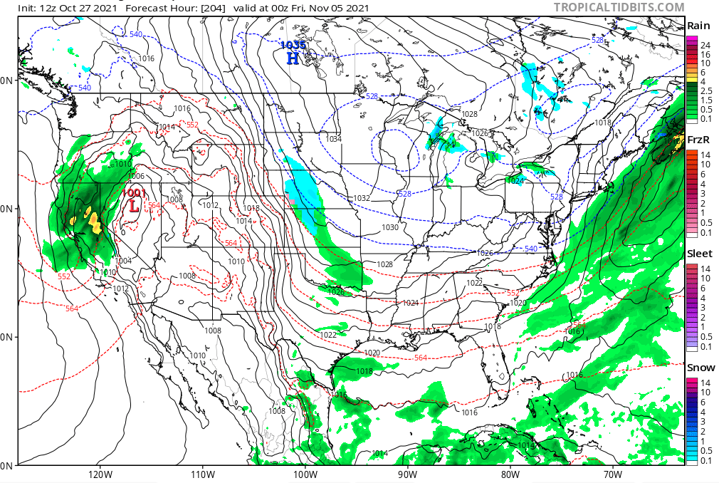
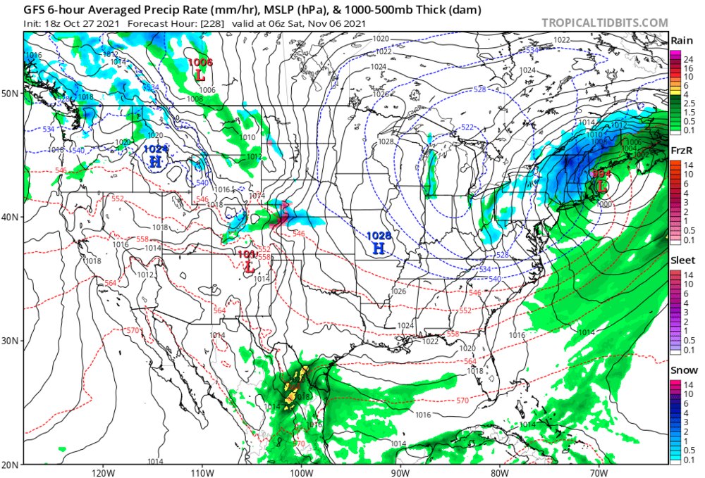
Agreed ... If I might add ( imo ). Normal to even below normal ( imagine that ) during early November was the only hook and draw for the period. If we get to November 10, having the best realized cold impact be shallow interior ponds briefly freezing over, while (at least) finally the lawns stop growing ( jesus christ), folks with rational expectations will be fine with it. Which concomitantly means, if anyone posts one f'ing intoned turn of phrase that grouses matters at that time, that means you are not rational mm-k there frosty pumpkins. Now, obviously there is sane truth to the notion, you cannot snow without supportive atmosphere - and in principle, not being in the 70s helps. In fact, having hydrostatic heights below 540 dm, helps quite a bit too. So in this sense we have 1 aspect in field-equation's worth of variables - check! There is some weight in operational run suggestion/continuity of that one particular aspect. Combining telecon spread ( from the GEFs system), to lay in a "snow atmosphere" ... at least is foundation. It's definitely originating in the large synoptic evolution - I like that, with first entry northern Plains, than seasonal negative anomalies spreading eastern to the Lakes and eventually upper OV and NE... We began sustaining a -NAO weeks ago, and that's on-going. I am noticing the D7 to 10 in the 00z operational (Euro and GFS ) are in fact deflating the lower D. Straight block, and a new one formulates over the NW Territories of the Canadian Shield. This total behavior is really indicative of a 'block favoring' hemisphere, overall. So, it's hard to target the NAO as any more or less causal in any set up, over just the former distinction playing its role. Interesting... Meanwhile, the American system's PNA is bouncing around positive. This in total is a low to medium cold-biased pattern for the mid latitudes of the continent, and so ... that's the frame up for the colder regime. This appears to last 3 or 4 days. The front side, and end periods of that range might feature something more specific that avails.
-
Same ... lawn's ashen aglow as though mortified in the night and is now wise; ha, sort of like when life's taken its toll. I tell ya, I was a bit perplexed this didn't headline from our NWS office(s) where applicable, late yesterday. It was air apparent this was a heavy frost, borderline hard freeze night and I don't believe the region had to-date passed through that rite of passage into deep autumn. I wondered if perhaps they opted out of issuance, if based upon the notion that the growing season had simply, already just run-out of time; belayed seasonal first dip allowing it to gradual extinction ... now irrelevant to warn. However, upon reading their AFD, the content didn't reflect that reasoning. It was odd, with statements like, ' ... the colder areas might make the low 30s so patchy frost could take place' - or words to that affect. Uh, ya think? 27 to 30 appears to be a common backyard home-station low when popping around Wunderground, and looking at Mesowest's rendition, FIT and ASH were 30 and BED was 28, so I don't have a problem with the Wunder spread here. This was a heavy frost headliner overnight over a large aspect of the interior, that was borderline 'freeze' by definition. Big deal? No. Of all the headline impactor facets of weather, ... this has always struck me as lower priority. Frosty nights are not doing anything that cannot be accepted as maintenance 'normal' inconveniences. But ...I don't mean to cast anti-cancel-culture "shade" over the 'first-night-of-30 f' crowd and hurt their feelings, either -
-
Our AFD is oddly out of touch with this down here. Huh. Talking like it’s “ possible some areas might need a frost advisory. “ Wtf. 32-36 everywhere already. Interesting
-
Today felt like it should entering November - or reasonably within range … just sayn’ but I know I know I know autumn can be a long haul bore.
-
… 40 already here. Coldest so far this season relative to time of diurnal Heavy glow lawn frost seems imminent Curiously … has there been a policy shift on frost headlines/issuance. I don’t believe the region has pervasively experienced one this season, and it seems tonight is a candidate for that but maybe I’m missing something. Perhaps no for the general presumption of end-growing season is already consumed
-
X 1 ?! ooh
-
Yeah this is about the the very best one could ever ask out of a Novie 6 Not sure how and what will manifest within, but that first 10 days of November has been signaled for quite some time as a period of colder temperatures …However so anomalous to be determined. That isn’t the first run above that suggested something similar might emerge. Got some Telecon support
-
Has that look of air mass where crispy mornings feature pond ice around edges, and still there in the shaded inlets late afternoon ... Nov 3-10 .. who knows thereafter.
-
Potential Major Noreaster 10-26 through 10-27
Typhoon Tip replied to ineedsnow's topic in New England
Guess it depends on "effect" context and aspect/profiling therein ... Bob ate the region for a dining tab about $1.5 billion according to Wiki- so .. fwiw We'll have to see what/how limbs littering lawns and power infrastructure tallies compare. also ... I wonder what the marine/harbor impacts were -
-
October Discussion: Bring the Frost-Hold the Snow
Typhoon Tip replied to 40/70 Benchmark's topic in New England
Yeah... I think I'm good and ready for this Nor'easter to trundle its way out into its death smear across the norther Atlantic and good riddance. After awhile with these things ... I tend to get storm fatigue. Almost "modeling and following the f'er ad nauseam" fatigue, is more like it. I just get to a point, sometimes even before they happen where it is 'enough is enough' already. How many different model renditions of the same event does one need to field. Particularly when we all know it will strike one or two communities while sparing the rest of us a pedestrian ordeal. It's like a state Lotto ... If you are that lucky town, you won that storms drawing. And its like somehow by escape into the model triggered re-imagined reality, we up our chances of picking the right numbers on our tickets. So, most don't win.... But, because we risk "hurting the storms" feelings, during cancel-culture, or risk getting black-listed in the weather-social-media's equivalence to the House on being Un-American Activities Committee or something... the storm gets to be an all-timer. Gosh forbid one ever is - ..who's gonna know it? -
October Discussion: Bring the Frost-Hold the Snow
Typhoon Tip replied to 40/70 Benchmark's topic in New England
Really ... nah - I see a teleconnector signaled, trend-footed confidence scenario for a "seasonal cold" wave - meaning ...nothing extraordinary, no. But pervasive sub 540 hydrostatic thickness, under a generally moderate +PNAP flow structure that pervades the continent, from ~ Nov 2nd through the 9th. Of course, that's going by the tenor of the operational GFS, combine with the telecon from the GEFs system - still... I don't find these sources, in that time range, to necessarily be auto- less reliable than the EPS cluster. I guess we'll see. But ...you know? part of the problem is that we are 'extraordinary event' saturated to the point where we don't see the middling 'normal' departures as readily. It's sort of conditioning us to collectively even inadvertently miss if not ignore them, altogether. Case in point: Imagine a scenario where there are three distinct winter events in a 10-day period. One is 3-5" with a big scale -up potential, one is 3-5 but is sketchy, but the D7 one is a historic blizzard. The first one verifies 4.5" ... while the D7/8 comes in modeled even more terrifying catastrophic.. The, the next sketchy one does surprisingly well, but by shadow of the looming ( now ) D6 cryo-bomb, does anyone even know it is snowing? Then, the big dawg busts. What do you think the opinion of those 10 days will be, when in fact ... 9 or 10" is a 7 to 10 day +snow anomaly? This is the life as weather chart over-stimulated storm junkies - not a very good or realistic perspective. I mean I'm not saying this is you .. I'm speaking the straw American weather site - ..Something like that and over-numbing may not be seeing this cool down in early November ( and this is in spirit been consistent for several consecutive cycles of the GFS) - and again.. fits the erstwhile PNA/NAO ... even hints in some Euro runs for -EPO 'blip' but cross that bridge:
-
Potential Major Noreaster 10-26 through 10-27
Typhoon Tip replied to ineedsnow's topic in New England
While right to say it he is unfortunately futile for the effort, for there is no audience in social mediasphere available to really hear that message. It would be like trying to penetrate some street corner heroin addict's mind with wellness rhetoric. The charts and graphics? They are either the needle, or the junk in the needle. The feed-back on line from others also seeking' the push', bouncing back and forth between ... ever amplifying the fever-pitch? That is the act of plunging the syringe. It is all part of the same force that was outlined in "60 Minutes" expose' ... or NETFLIX' "The Social Dilemma" - this in here? It's just our brand. ...So, it's a societal problem ..which this can go off at tangent indefinitely at this point heh. I mean, the Internet, and the vastness of how it touches all using tech related direct, or indirectly to it, now pushes the motifs to modalities infinitum .. to the point where quantifiable it is most probably the most extraordinary thing Humanity has ever contrived - and we don't even know it for being in the weeds (feels too good to question anyway - right?) We are living the greatest dystopian ( or utopian - verdict is still out...) novel that never was actually written. I don't mean to excoriate any one "user" in our midst - lol. Lord knows, I sense/feel a charge out of a deep digging winter trough, just as well... But there is a difference between feeling that sense of awe and wanting to experience x-y-z, vs a tendency to shuck rationalism, and/or any dissenting opinions that even 'sound objective,' in lieu of re-enforcing bias ahead of time. Sorry, that is creating a delusion - almost by proper definition. Create a bubble of constant fascination to fixate within a framework of less-likely plausibility, just like these expose' evince, is an escape ... into a psychotropic high. And yet another tangential: there is no consequence in lingering there in a modern industrial-mollycoddled assumption of security. This is a problem... I love discussing this stuff and I realize this is probably not appropriate here, but the over-arching "buy-in" to the media is apropos. I digress.. Still, much of the leading proportionality was well met for SE zones - that's the enabling lie. "It wasn't that I believe the fever-pitch; it just didn't penetrate as far" I mean it's easy to sense ( thus) why folks get palpably pissed-off ( ...though think they are hiding it heh -) when 4 days before a modeled winter storm, the models so much as hint the bubble might deflate. In some sense of it, the actual storm its self is less important than the bubble of excitement created ahead of time - you pop that bubble, oh boy ... It sets off Facebook fights and Twitter rages, or trolling ... far worse than any storm fashioned by careful selection of graphics and dystopia feed-back loops -
Potential Major Noreaster 10-26 through 10-27
Typhoon Tip replied to ineedsnow's topic in New England
Yeah the Ida comparisons were annoying eye-roller material ahead of this thing -
Potential Major Noreaster 10-26 through 10-27
Typhoon Tip replied to ineedsnow's topic in New England
I wonder what he thinks now ... heh -
November 2021 Chilly Blast (1st Wave)
Typhoon Tip replied to Iceresistance's topic in Weather Forecasting and Discussion
I'd watch in suspect for those anomalies to normalize toward a more seasonal cold departure .. gradually, as the days and model cycles click by over the next week. -
October Discussion: Bring the Frost-Hold the Snow
Typhoon Tip replied to 40/70 Benchmark's topic in New England
Ah ha. I bet you a dozen donuts no kid likes rectal plaque weather, either -
Potential Major Noreaster 10-26 through 10-27
Typhoon Tip replied to ineedsnow's topic in New England
It’ll keep belaying until it never actually happens LOL -
Potential Major Noreaster 10-26 through 10-27
Typhoon Tip replied to ineedsnow's topic in New England
Heh … fleeting presence is apropos but yeah