Typhoon Tip
-
Posts
44,539 -
Joined
-
Last visited
Content Type
Profiles
Blogs
Forums
American Weather
Media Demo
Store
Gallery
Everything posted by Typhoon Tip
-
May 2024 Discussion - Welcome to Severe Season!!!!
Typhoon Tip replied to weatherwiz's topic in New England
Agreed the wf seems stagnant. By the way, I've also developed an anecdotal local correlation between morning rain/elevated convection on days where SNE does well. Like all ...it's not 1::1... Something I noticed over the seasons that followed the Derecho in 1987 that came roaring down the Mohawk Trail. The Monson tornado in 2011 ..there are others. There was a morning garble that seemed to imply a drab cold rain miserable day. But then the sky brightened by noon or 1pm sending T bursting under blue skylights. Boom -
May 2024 Discussion - Welcome to Severe Season!!!!
Typhoon Tip replied to weatherwiz's topic in New England
I haven't read any studies but I think - my own supposition - there might be a relationship with the Lake Michigan boundary layer interface with the land over that area. When there is a S humid flow, with a west wind aloft, you have a deep layer helicity issue anyway ... but, think about having the Lake boundary, there ... it might enhance/give a boost to the SRH below the mesos. Cooler, stable flow would back the llv wind slightly more westerly, with S winds immediately out ahead. The interface provides an easy curl Thing is... Flint Michigan had a F4 monster the day before the Worcester 1953 event. It was in fact the same synoptic package. But that's pretty far away from any such mechanism and unlikely related... There is a 24-hour Michigan correlation to Massachusetts specifically, btw ... Severe in southern Michigan tends to precede severe in SNE by 24s with fairly high coherence. Seems today we may miss though ... the clouds are not clearing behind our morning warm frontal ib burst. we'll see. -
May 2024 Discussion - Welcome to Severe Season!!!!
Typhoon Tip replied to weatherwiz's topic in New England
It's my home town when I was boy my family members still living around there are hearkening back to May 1980, when a (then) EF3 tornado carved a canyon right down Michigan Ave through the heart of the city. I was at the gym yesterday when on the television I caught sight of the tornado watch graphics. At the time, the radar had cluster of severe cells moving up out of NW Indiana. I went onto my phone and savvy rad sites saw two clear hooking super cells within that group - holy shit. One went right over the city, after ( thank goodness) it had already put down the finger of god, but spared 1980 by lifting the vortex into the meso just in time. My sister lives about a mile S of the city center and had golf ball hail do a solid number on prized shrubbery - she's very grateful. The other went SE of Kalamazoo County, up through Calhoun/Battle Creek - smaller city and home of Kellogg cereal to the East of the 'Zoo. No word on that one - it may have stayed entirely elevated. My initial take was that both would miss where my family members reside. I must admit to feeling a little irresponsible and very, very lucky, because that meso went right over the city. I'm hoping some vids will surface to confirm... Anyway, it was close, too close to have not phoned my sisters and father as someone that saw these super cells in the vicinity. I have some guilt - blessed that it's not confirmed! I remember 1999. I was working ... WSC I think it was called. They don't exist any more. Weather Services Corporation, I think it was. I saw the very first radar blip of the famed F5 tornado near Oklahoma City, when it was some 10s of miles upstream. Within 5 or so sweeps, it was already rotating. I remember just looking at it, and the path along which it was extrapolating, and one word occurred in the internal monologue: "Jesus" ...within an hour it was a 75 dbz core with rancid abortion coat hanger hook, replete with debris ball, going right over dense township labels on the map beneath the radar scope. Several of us Mets were by then watching the cinema from our seats that evening - crazy. It's tough... when you see and know ahead, and you think about the population that cannot see,lacking enough of any background to know ... probably just carrying on oblivious while the home denudation bomb blithely arrives. Mind you, this is prior to iPhones. In 1999, society was still vastly less individually informed. There were no loud pings on any devices, warning people of impending calamity like now. -
May 2024 Discussion - Welcome to Severe Season!!!!
Typhoon Tip replied to weatherwiz's topic in New England
I'm on the fence ... On one hand, the GFS rages on with an amplitude bias that surpasses all other amp bias' across all guidance, that kicks in around 96 hours. The flow is slowing ( hemisphere ) and I suspect that it's amplitude bias shifts <- ...etc. Lot of intuitive experience with this guidance. Plus, the GGEM is noted ( I mentioned that myself earlier) and would make sense. It has good continuity between 00z and 12z, where the GFS is all over the place. I just think the GFS trips over it's own amplitude fantasies. On the other hand, pure experience. New England's unique p.o.s. spring climate cannot be discounted. Pistol to the head I suspect the GGEM is closer to right with some caveats perhaps. One other aspect that's seasonally heading toward the back burner, but the teleonnectors are in aggregate a warm basis for the next 10 days to 2 week. At some point that may and probably should begin to present in the guidance. -
May 2024 Discussion - Welcome to Severe Season!!!!
Typhoon Tip replied to weatherwiz's topic in New England
cool -
May 2024 Discussion - Welcome to Severe Season!!!!
Typhoon Tip replied to weatherwiz's topic in New England
For the hawks nests maybe. I don't diminish the cold profile at this late in the year, but that's the eastern region of the Tug Hill, which has an elevation around 2,000 ... than again S Greens and up there near the Presidential Range in NH. -
May 2024 Discussion - Welcome to Severe Season!!!!
Typhoon Tip replied to weatherwiz's topic in New England
which seems it must be 300% of normal for this stability hole of a wasteland -
May 2024 Discussion - Welcome to Severe Season!!!!
Typhoon Tip replied to weatherwiz's topic in New England
NAM went N with the warm boundary for tomorrow. Has it pretty darn SRHy looking on this run between the Pike and rt 2. Bit warmer too as a consequence. -
May 2024 Discussion - Welcome to Severe Season!!!!
Typhoon Tip replied to weatherwiz's topic in New England
I saw Ryan mentioned an EML ? -
May 2024 Discussion - Welcome to Severe Season!!!!
Typhoon Tip replied to weatherwiz's topic in New England
Wow, look at LGA's grid data (NAM) for tomorrow at 18z 36000 38 32 29 -1098 022714 64 26 19 08 that's a pure open sear sun sky with a T1 of 26C ... the 2-m slope temperatures probably 31 C there with that straight west wind -
May 2024 Discussion - Welcome to Severe Season!!!!
Typhoon Tip replied to weatherwiz's topic in New England
hybrid air mass -
May 2024 Discussion - Welcome to Severe Season!!!!
Typhoon Tip replied to weatherwiz's topic in New England
Look at the 00z version... less than half. It's all over the map. That second coastal/nor'easter spin up it's doing for Friday has been placed from NS to N of Maine to Cape Cod about every other run for the past 3 days. I guess what I'm getting at is that continuity being less than optimal doesn't lend to confidence that any one solution will turn out true. Which ...haha, backs us into 'hope' that none of them will be, and we'll instead have a nicer weekend - like the GGEM. Which isn't ideal, but is a helluva lot better than the GFS' misery grind. -
May 2024 Discussion - Welcome to Severe Season!!!!
Typhoon Tip replied to weatherwiz's topic in New England
Hopefully the 00z GGEM is right. It suppresses that 'coastal' winter -like synopsis on Friday. I'll take the cool thicknesses but at least dry, and at least some partial sun, over the GFS' 70 straight hours of misty murk when not chilly light soul-sapping rains. The GFS is ridic, man. It does that extended cyclonic smear with east wind drab rains crap from a system that looks February only too warm for snow, for like 30 straight hours, only to then spin up a coastal nor'easter. I'd love to see that be all be flat wrong for two reasons. A, I don't want that. But B, I'm sick of this model consummately trying to regress the advance into the warm season - it just always leans on the coldest most vile solution it can find at this time of year. The only problem is, we are in a time of year when our climate also leans on the most vile solution it can find. It's not helping ... -
May 2024 Discussion - Welcome to Severe Season!!!!
Typhoon Tip replied to weatherwiz's topic in New England
There was a lot about that game that was almost poetic -
May 2024 Discussion - Welcome to Severe Season!!!!
Typhoon Tip replied to weatherwiz's topic in New England
I just need Sunday to end up on the fairer side - can you work that out ? -
May 2024 Discussion - Welcome to Severe Season!!!!
Typhoon Tip replied to weatherwiz's topic in New England
mm...I also wouldn't trust the NAM with those metrics. It's been vacillating between completely cloud and mostly sunny for today, for example. -
May 2024 Discussion - Welcome to Severe Season!!!!
Typhoon Tip replied to weatherwiz's topic in New England
Dry micro bursts ? -
May 2024 Discussion - Welcome to Severe Season!!!!
Typhoon Tip replied to weatherwiz's topic in New England
Whenever I see one of these alerts down there I'm always struck with this notion that the region in question is really in a constant state of meso-beta ( between synoptic and meso ) scale circulation, already. Like a static, if not quantifiably rotating field relative to the surrounding medium, certainly intense potential vorticy. It could be a sunny day with no jet streak moving over, no DP gradient fairness, ...that region still slowly turns around itself. Just a matter of whether it gets focused. This is going to be really bunner comment here ...but, I've seen this watching slowly whirling leaves around the lee sides of buildings and when a gust comes over top ... it provides a wonder natural laboratory. The slowly whirling leaves suddenly contract into a rapidly spinning column as/while the gust is roaring over from over the building and passes over that same region. It's really the same thing in principle. We dawn with "slowly turning leaves" down there, and wait for some jet streak to come over top the "rockies building" - it passes over, triggers a lift, stretches the vortex which contracts it's diameter ... and away it columnates. It's like if we lived on a world that didn't have water, there'd be tornadoes there anyway -they just wouldn't be connected to any thunderstorm CBS. heh interesting. -
May 2024 Discussion - Welcome to Severe Season!!!!
Typhoon Tip replied to weatherwiz's topic in New England
The mood is down in here today ( apparently ... heh ), because in being slaved to photo-electric effect, the brain circuitry misses the direct sunlight thru the warm air we were promised on people's faces this morning. If it were 64 already with warm sun corpuscular rays beaming thru the morning budding trees of May and all that, we'd be spinning things more optimistically - understood. It could be ... vastly worse. May 2005 makes this look like a Hawaiian get away. -
May 2024 Discussion - Welcome to Severe Season!!!!
Typhoon Tip replied to weatherwiz's topic in New England
You can go ahead and expand this perspective into the total arc of human evolution. Climate has been a modulating force on migration pathways and establishment depots during all three major migration events out of Africa. This is known yup. No one asked me but the only thing stopping me from going elsewhere at this point is loneliness - ha... I don't want to to commit to any such venture, by my self, and have to start over at my age. Interestingly, there is this new reverse aging technology. Apparently it's working in mice. Like they've cracked the code of death. They've taken these mice that are geriatric, and reverted them back to svelte and virile. Solving problems and getting phone numbers from the babes in the other cages. If this were somehow scaled up to humans? Yeah, given another 70 years of good looks, intelligence, and hot girls, might make it worth the while Lol. Most of my erstwhile life I was on the tolerant side of this New England's time stealing season known as spring. I was tolerant because I had a kind of tacit agreement with nature: you get to violate my will to live in the spring, because you're giving us big winters. It was a willing trade off. Besides, albeit rare, some years would turn balmy, early, and stay that way. And usually, July is still coming whether spring liked it or not - we'd get at least a couple of months of that 80+deg, golf and beach nostalgia. But lately? Winters are a root-canal, while summers are becoming too submerged in DPs mixed with "continental B.O." - I don't know what you call that polluted miasma we've been getting in recent summers, but it's causing these black mold blooms like red tide in the house. Summers are becoming eerie. And springs seem to eat later and later into summer. The deal is off! Taking time away from higher sun angle time of the year and eating into the warm season, while our winters are increasing sucky. That's another reason why people migrated from the Brit Empire ... taxation became unfair. ... Without winters? what's the point. It's a good thing the climate isn't changing I keep getting post cards and cold calls, and texts from strangers offering to buy my house, as is, ...dinner plate departure, for cash - meaning you drop what you're doing and just give them the keys for X amount of dollars. Literally, 'no cleaning necessary. Leave the furniture ...', etc. A lot of people are getting those around me, too. I guess most of the population doesn't give a shit what the weather's doing because I'd-a thunk a climate frustration triggered diaspora would lower real-estate demand I dunno. Point is, I can probably get out here if it got bad enough - but where to go? Cloudy, 53 .... supposed to be 71 but it's cloudier than modeled as a last minute adjustment - go figure. -
May 2024 Discussion - Welcome to Severe Season!!!!
Typhoon Tip replied to weatherwiz's topic in New England
The difference between today and tomorrow will be among the more impressive single day changes we've seen in quite some time, pan-regional. Especially in your lower els that escape the fog capped valley inversion - which I think the wind will be establishing a S bias in the Notch. No one's really talking about that as it's a non-injurious notable but 46 to 76 isn't out of the question say St Johnbury region, and that's true for down our way too. It's 49 here mi casa this hour, steady R- Can't find a model lower than 76 here when factoring in the typical 2-meter sounding slope. This is one of the deals where the whole system sensibly is more like a warm front, even though a cf clears the region prior to dawn. It's one of my personal labeled type of system, more common in autumn and spring - where the cold is on the front side only. Only when this does it is spring, you get the sun booster to really bring the point home. -
May 2024 Discussion - Welcome to Severe Season!!!!
Typhoon Tip replied to weatherwiz's topic in New England
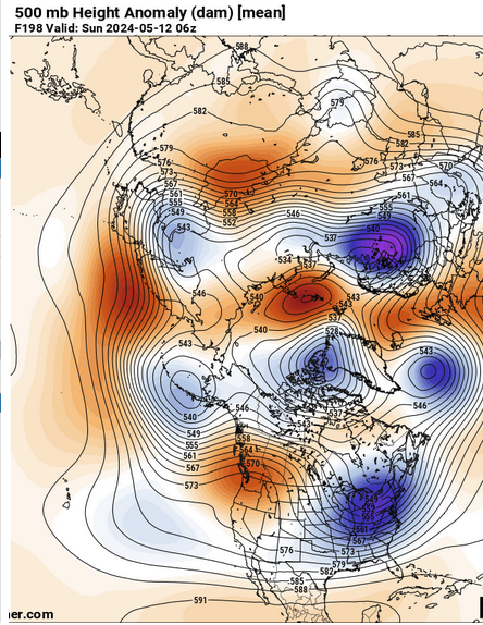
It's subtle . .. but, the 12z Euro's trying to normalize that D5 - 10 pattern. It's got a ways to go but it's not as obnoxious with the 500 mb height synopsis as it was in prior runs. Wednesday may have some interesting convection with that entangled warm boundary/weak cyclone deal. Nice theta e pooling in CT with a strong temperature gradient in that vicinity, with a modest mid level wind max/right exit jet region coming in over S surface winds. -
May 2024 Discussion - Welcome to Severe Season!!!!
Typhoon Tip replied to weatherwiz's topic in New England
And that's actually better than the 00z and 06z in the sequential order. I mean ... it's been getting better - imho. But still is above the vomit threshold - ha. One upshot is that it's keeping the pattern progressive while that +PNA trough spends that 5 days in there. We're not stalling lows in the area. I'm also noticing that we aren't pulling as much "blue line" S of the border as much as prior runs. Maybe it's bad pattern and at the same time the model's admitting that the sun is hot now. jeez -
May 2024 Discussion - Welcome to Severe Season!!!!
Typhoon Tip replied to weatherwiz's topic in New England
Getting two days, back-to-back, above 70 F in this -NAO relaying into a +PNA is actually a pretty fantastic achievement relative to that predicament. Beyond that, NWS is right ... probably 5 to 6 consecutive days of BN. How much, or if we can pull a 'normal' day out of that stretch will come down ( as usual ) to the amount of sun. The Euro variant would be on the uglier side of a frontal boundary, with cyclic waves running out along or S of LI Each one enhancing light rain and raw E drift to the air. Couped up cabin fever at a time of the year whence that is clearly stealing what precious time we have for summer in this godforsaken cold dumpster region of the continent... This is entry into solar maximum week ... From now through August 8 we are getting what we're going to get from old sol - I'd rather not spend a week of it rotting but to each is his or her own. That all said, I suspect the Euro is over doing it with those thermal profiles S of ~60 N across the continent after D 7 or 8 ... that looks like typical model trying to eclipse the season shit we see in that time range during spring modeling season. For that matter, there some possibility these models are all wholesale over doing that L/W rangle in that time range. -
May 2024 Discussion - Welcome to Severe Season!!!!
Typhoon Tip replied to weatherwiz's topic in New England
Be careful though. We may not cleanly exit the shits like that. The PNA is being forecast to flip modes into positive in the Euro's recent ensembles - fwiw. The GEFs are bit tamer... rising to neutral index, but the Euro brings back February. This can be seen both in the numerical telecons, but also in the larger hemispheric synoptic mean. If it has legs we shift away from the -NAO shits, right into PNA diarrhea. Models do tend to be over amplified as a standing correction ... Pretty much everything they're handling beyond D 4 ..5 ..etc, tends to prove magnified. Factoring that in might bring a more realistic/tamer GFS solution that much back from the brink of disastrous misery. Suddenly some redemption, etc. By arithmetic, that would require a big correction from the Euro, though. This is ensemble mean, mind you, at 200 hours Anyway ... have to see if the PNA is being overly baked by the Euro. This kind of game of relaying from one rapist to the next hemisphere has been a spring plight around here going back years, on top of a climate that is also questionably tolerable to begin with. Therefore, it fits the multi-seasonal trend? so to speak. It just makes the idea feel right ha