Typhoon Tip
-
Posts
44,539 -
Joined
-
Last visited
Content Type
Profiles
Blogs
Forums
American Weather
Media Demo
Store
Gallery
Everything posted by Typhoon Tip
-
May 2024 Discussion - Welcome to Severe Season!!!!
Typhoon Tip replied to weatherwiz's topic in New England
Ooh. that's an Arachnophobic Succullotta ... very dangerous. Don't mess with those! -
May 2024 Discussion - Welcome to Severe Season!!!!
Typhoon Tip replied to weatherwiz's topic in New England
Between my childhood and ~ 2000 ... I never saw snow in May. I've seen it now 10 times since 2000. That's what I mean ? I'm not refuting what you're say, re the four seasons of New England: Summer, Autumn, Winter, Butt Bang Like I said... it's hard to parse out which is which in terms of quota in the question of 'how much of this is just our climate vs being exaggerated by CC' - speculative on this latter point, of course. But just imho I don't think the hockey stick climate acceleration in the last 25 years, vs the sudden frequency shift in odd-ball late cold so pernicious that we have busted virga cu packing pellet flurries like it's Thanks Giggedy in May, is merely accidental. -
May 2024 Discussion - Welcome to Severe Season!!!!
Typhoon Tip replied to weatherwiz's topic in New England
Nothing will ever beat 2005 May hahaha. -
May 2024 Discussion - Welcome to Severe Season!!!!
Typhoon Tip replied to weatherwiz's topic in New England
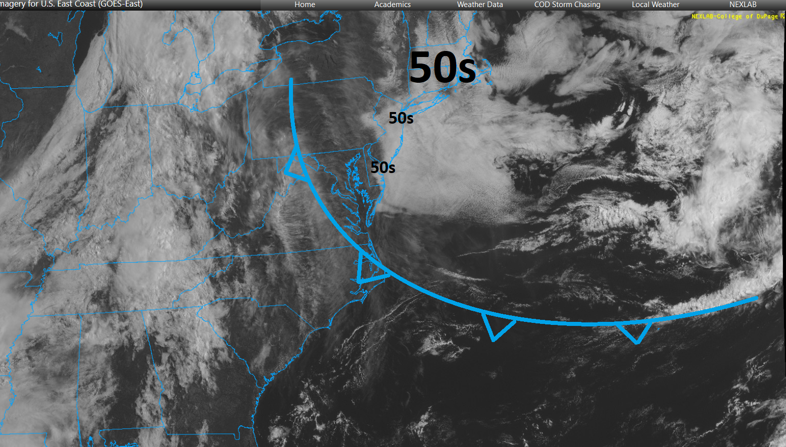
Man, this is may be a record breaking BD - if there were such a tracking... in terms of mass alone this thing is HUGE https://weather.cod.edu/satrad/?parms=regional-eastcoast-02-24-1-100-1&checked=map&colorbar=undefined
-
May 2024 Discussion - Welcome to Severe Season!!!!
Typhoon Tip replied to weatherwiz's topic in New England
It's deep enough in the atmosphere that it may actually partially clear from the NE.. There are clear patches over the lower GOM region on sat. They, and the patches of Labrador shit streak strata are en masse moving fairly quickly SW. So best hope is to have one of these pass over one's region. It's about all there can be mustered that is redeeming. I think this is CC related. These May putrid patterns are part of the spring blocking thing that's been happening with increasing frequency over the past 20 years. It's very complicated ... As the winter seasonal velocities start to come down, and the wave lengths start to shorten, closing off high latitude ridges is naturally going to occur anyway, but we're seeing a preponderance of it that's more than that. It's probably impossible to parse out the natural tendency from the exaggerated tendency, in this case. -
May 2024 Discussion - Welcome to Severe Season!!!!
Typhoon Tip replied to weatherwiz's topic in New England
I suppose 'as is' ... but, it looks fragile. we'll see. -
May 2024 Discussion - Welcome to Severe Season!!!!
Typhoon Tip replied to weatherwiz's topic in New England
mm fragile. let's not have any faith in that, either. just my opinion, but we should set the bar pretty low for a learning disabled hemisphere Just long years of experience talking with never winning in the fight against these sort of abysmal spring plague patterns - the worst of all possible outcomes verifies the vast majority of times. In other words, something will emerge to f-up Tuesday too. -
May 2024 Discussion - Welcome to Severe Season!!!!
Typhoon Tip replied to weatherwiz's topic in New England
Monday and Tuesday don't look like decent days to me. May be just my preference, but when the boundary is suppressed to barely underneath our latitude with waves rollin' along it... we're not getting balmy buds of May weather -
May 2024 Discussion - Welcome to Severe Season!!!!
Typhoon Tip replied to weatherwiz's topic in New England
5 Mays in a row defined as having to scrape decent moments, if not a day, only once out of each p.o.s. week ... -
May 2024 Discussion - Welcome to Severe Season!!!!
Typhoon Tip replied to weatherwiz's topic in New England
If it stays overcast, it won’t be that warm -
May 2024 Discussion - Welcome to Severe Season!!!!
Typhoon Tip replied to weatherwiz's topic in New England
You actually can see the back door on high resolution radar as it’s sweeping southwest through the area should be entering north eastern Connecticut over the next hour overtaking Kevin mid evening… Not sure what it’ll mean for tomorrow’s temperatures again it’ll come down to how much sun -
May 2024 Discussion - Welcome to Severe Season!!!!
Typhoon Tip replied to weatherwiz's topic in New England
It’s all gone tomorrow -
May 2024 Discussion - Welcome to Severe Season!!!!
Typhoon Tip replied to weatherwiz's topic in New England
seems like it's been a reenforcing BD every 18 hours for 6 days now -
Occasional Thoughts on Climate Change
Typhoon Tip replied to donsutherland1's topic in Climate Change
It's not a bad 'global vision' yeah. I could see that. Unfortunately, that still would be too late for a lot of fragile species that cannot adapt ( down to evolutionary genetics!) quickly enough, thus will go extinct. I mean this is already happening - not supposition on this point. We are in mass extinction when expanding to geological time scales. Anyway, it may also not take PETM to lurch and trigger vastly more injurious consequences than are foreseen. In fact, I'd almost count on that. Intuitively we don't need 5 deg before crazy enough stuff starts happening within that uncertainty manifold. Enough so to enforce population correcting in our species - even if people think we can exist on this world in a vacuum. The funny thing about that op-ed there... birthing rates, globally, are plummeting already. Not sure if this sociodynamic randomness, or some sort of biological aspect with pollution or both... I suspect both. "Millennials" aren't interested; a one generation distinction but it's broader than that. Meanwhile, fertility in males is falling at alarming rates. -
May 2024 Discussion - Welcome to Severe Season!!!!
Typhoon Tip replied to weatherwiz's topic in New England
This is a nerdly interesting... The ensemble spatial-synoptic evolutions do not look very representative of the numerical teleconnectors. That's a little unusual. Neutralizing NAO and a negative PNA should be laying out a warmer canvas over the mid latitude continent. Yet the means synoptics try to prevent summer from ever getting here. The operational version are even worse. The GFS is trying desperately to snow for PF on D10 ... if fails, but it's just seething in want of doing it. jesus christ. April is supposedly the warmest month ever in the world or whatever ... yet again, in an endless series of always warmer than the one before. Just sayn' -
May 2024 Discussion - Welcome to Severe Season!!!!
Typhoon Tip replied to weatherwiz's topic in New England
back building narrow cloud axis should make today's max temp interestingly targeted -
https://www.cnn.com/2024/05/02/us/video/pfas-forever-chemicals-farmland-food-biosolids-digvid ... there are other things that'll kill you because of human ingenuity. The more time that goes by, decades and counting, the more so it appears there is no way off this road. We've sold our futures to innovation and ingenuity, generations ago. Separate discussion but ... human innovation may very well turn out to be the most destructive force this planet has ever known - the verdict is still out. We are going to have to emerge equally as impressive measures and method to ameliorate. The reason why, these various systems appear to be set upon a momentum that is no longer capable of self-correction, a predicament that seems more and more so to require that same capacity to fix. "Silent thresholds." Somewhat analogous to the event horizon of a black hole: the observer doesn't necessarily notice or sense anything unusual when crossing that boundary - only that they can never return to the previous paradigm. The momentum carrying us into a CC realm cannot be countermanded merely by cutting C02 at this point - we've slipped through the proverbial horizon. PFAS and BPAs etc...etc... these so-called "forever chemicals" ( great idea, huh ), the 'momentum' of the damage they cause, the question should naturally arise, will that last forever, too? -this is simple logic.
-
May 2024 Discussion - Welcome to Severe Season!!!!
Typhoon Tip replied to weatherwiz's topic in New England
For warm/spring weather enthusiasts this next 2 week is a direct attack on you personally ... It's giving you days like today, ephemeral and unsustained ..., deliberately so that it can bring you 44 F light rain all day on Sunday at a spiritually maximized torture. A routine the operational models appear to attempt to repeat several times right out to mid May. -
May 2024 Discussion - Welcome to Severe Season!!!!
Typhoon Tip replied to weatherwiz's topic in New England
frustration/kidding of course... -
May 2024 Discussion - Welcome to Severe Season!!!!
Typhoon Tip replied to weatherwiz's topic in New England
nope... apparently, this strata is not physically reactive to any kind of electromagnetic power of the sun - https://weather.cod.edu/satrad/?parms=subregional-New_England-02-24-1-100-1&checked=map&colorbar=undefined -
May 2024 Discussion - Welcome to Severe Season!!!!
Typhoon Tip replied to weatherwiz's topic in New England
Seems the sensitivity is almost entirely NAO causal. I'm noticing that same general improvement after this weekend in the panache of the guidance out in time ( variable depending on which.. but by and large). Meanwhile, all ens sourced teleconnection coverage shows an abrupt neutralization of NAO from ~ -1.5 SD to nominal by early week. The mid and extended range NAO is 0 SD flat-lined from ~ the 5th out into oblivion, after that point in time. Those two facets seem likely connected. During this and recency with -NAO we've kept seeing trough shrapnel and all other perturbations diving SE when nearing 90W/50N ... blunting back any continental westerly flow types from getting in here - that's the -NAO having established as a primary forcing mechanism on the current era synoptics. In short, we need to get rid of that f'ing menace. I also want to add, this is consistent with the last 5 years of spring NAOs. 4 out of the last 5 years have seen a -NAO between mid April and mid Mays. And these were not merely intraweekly excursions in the index values. These were definitive R. Wave structures that pulsed in amplitude in the negative phase states, spanning 2 weeks or more. Those months that were positive outliers, actually still had negative phase states that encourage at least transient negative anomalies. Probably why those positive average mo's were limited to a +.5 SD paltry range. These negative NAO excursive springs have(are) taken(ing) place regardless of leading ENSOs, too - just thought we'd clear that up now - which argues that there is a separate manifold of forcing that is causing this transition season cold regression to take place. We probably don't have to labor the fact that -NAO are going to be more problematic to temperature distribution in NE and SE Canada than anywhere else on the continent. Particularly when the -NAO is biased over the western limb of the domain - which they have been just going by both memory and a-priori. Well, looking at the two recent days of 80 F in N PA while we sniff low tide cool air smells in Worcester certainly fits the bill. -
Report: Another Year of Record Heat for the Oceans
Typhoon Tip replied to donsutherland1's topic in Climate Change
This is an interesting article over at Phys.org, https://phys.org/news/2024-04-atmospheric-teleconnections-sustain-blobs-northeast.html This is statement is concerning, "...The fundamental problem is that warmer waters hold less carbon dioxide and offer fewer nutrients for the plants and animals that exist there..." On the other hand, science has shown that the oceans in general "absorb 25 percent of carbon dioxide emissions and captures 90 percent of the excess heat generated by these emissions" - https://www.un.org/en/climatechange/science/climate-issues/ocean. ( I've read this in countless other direct sources of peer reviewed/publications) If (then) warmer oceans hold less carbon dioxide, and we are seeing the oceans warming at a non-linear increase ( the future will test whether that is temporary...), that should infer a -d(absorption) capacity. See ? this is how 'run-away' green-house warming begins. -
Occasional Thoughts on Climate Change
Typhoon Tip replied to donsutherland1's topic in Climate Change
Just in an intuitive sort of consideration ... it's almost humorous. It took this planet a half a billion years and more to create and stow all of these highly volatile 'fossil fuels.' Humanity, with their genius innovation, arrive on the scene "needing" to liberate that volatility ... back into a reactive environment, just since the IR. 500,000,000 years going in ... Since the Industrial Revolution, ~ 0.000045% of the same amount of time going the other way. How can that happen without consequence. -
May 2024 Discussion - Welcome to Severe Season!!!!
Typhoon Tip replied to weatherwiz's topic in New England
At a minimum requirement for recovering temp today the mid and high level cloud levels need to pass off. Check ... But as that miasma slips off the area, it is exposing some of the densest low level strata there can be without actually being underwater. man The sun is very intense at this time of year though. -
Hey... modestly entertaining to me. I consider you lucky all things considered. to each his own I suppose... Trying to brighten here. Temp surged from 51 to 58 when that happened. It really wants to be quite a bit milder than it is today, but clouds ftl