

Typhoon Tip
-
Posts
44,539 -
Joined
-
Last visited
Content Type
Profiles
Blogs
Forums
American Weather
Media Demo
Store
Gallery
Everything posted by Typhoon Tip
-
May 2024 Discussion - Welcome to Severe Season!!!!
Typhoon Tip replied to weatherwiz's topic in New England
You know ... this time of year is tricky to draft up what the model-based sensible weather would be. For one, the 00z run from 36 hours ago ( GFS ) had a SSE cool bite water inflow into a rain wall moving into western New England by 18z on Sunday. Looks noting like that now... Problem in part is that the flow character overall has seasonally weakened. The weakness allows smaller perturbation and changes from run to run, to dictate rather large sensible weather appeal difference. The MEX numbers look way warmer than the model's synoptic cinema would imply is really possible after Thursday. Yet BDL-FIT-ASH are all above 76 with 80s on Sunday. But then it occurred to me... ha, maybe the problem is my own. My brain is still in winter mode and hasn't gotten the memo entirely LOL. Can't assume strataform constructs so much anymore. Overall, this could be just a dewy-er stretch with more hit or miss showery/thunder Maybe just some early CB entertainment followed by a warm humid afternoon on Sunday. As for MD itself, the GFS has actually been all over the map with where to place QPF blobs and low pressure. Time to start thinking more summer. The seasonal torpid gradients and nebular characteristic makes the mid range darty.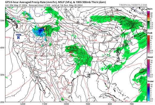
-
May 2024 Discussion - Welcome to Severe Season!!!!
Typhoon Tip replied to weatherwiz's topic in New England
Today looks like a modest warm bust so far - interestingly. 64 at BDL with strata murk packing. It's about 20 minutes from melting to mostly sunny so they'll burst rebound, but even here where it's been 90+% insolation since sun up, the temps are acting weighted. It's not clear why with the 925 to 850 potential, either. interesting. 71 ... 10 after 10 is under MOS/machine so we'll see. -
May 2024 Discussion - Welcome to Severe Season!!!!
Typhoon Tip replied to weatherwiz's topic in New England
This looks suspiciously too deep and nucleated to me considering the overall evolution of the total synoptic circumstances surrounding - which is more flaccid. But aloft the Euro is trying to phase a convective feed-back vort max with a wholesale N/stream incursion through the eastern Lakes. ah ....dubious. I think slightly weaker low moving up the St L. Seaway, with ( perhaps even ...) a convection day amid a warm sector. Since that would be what we want, it won't happen, and this anomaly below will just go ahead and take place. ha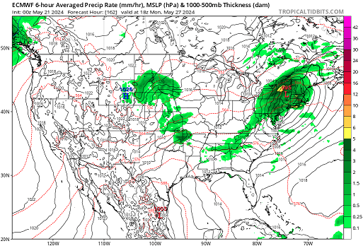
-
May 2024 Discussion - Welcome to Severe Season!!!!
Typhoon Tip replied to weatherwiz's topic in New England
heh... it seems like the models are 'de-amplifying' the entire synopsis in that time span, enough to lower the inundating cool and wet illustration to just inconvenience - I'm just comparing the blended mean from all guidance from previous runs/yesterday. Looks like as you say, 'showery' but that's offering some dry periods and probably at this time of year, intervals of sun getting through. What we obviously don't want ( and probably don't need even - ) is what the GFS was doing 30 hours ago: it had a huge polar high dome working into N Ontario, with a slow moving weakness at 500 mb carving out just enough nadir from Ohio to NS. That troughy ball sack was then getting squeezed by the high pressure exerting from the north, afflicting 2 straight days of painful easterly llv anomalies along with intermittent steady rain bursts... Ooh, sign us up. jesus - To me the blend now looks - at this time and subject to change .. of course - more like 4 hour periods where it's dicey with disturbances but there is 6 hours between them where it's probably partial sky and drier. As we know, it's not uncommon for the models to both be biased to amplitude when in the mid and extended, and to be too amped at this time of year. Both those error considerations may continue to help us. Of course ... sometimes this doesn't help at all - like July 4th weekend 2020. -
May 2024 Discussion - Welcome to Severe Season!!!!
Typhoon Tip replied to weatherwiz's topic in New England
73 .. I guess now that we're officially over the chamber of commerce temp that should mean we made the cut today. The play-in team - -
May 2024 Discussion - Welcome to Severe Season!!!!
Typhoon Tip replied to weatherwiz's topic in New England
heh. somethin like that - -
May 2024 Discussion - Welcome to Severe Season!!!!
Typhoon Tip replied to weatherwiz's topic in New England
Just touched 70 now. The 'cooler water issue' is only an issue when the winds are from that realm. What we've dealt with so far this particular spring - as I have personally observed - is a fractal, or repeating occurrence whence Sunday nadirs in temperature, followed by a mid week acme in the distribution tendency. This is going back several weeks worth, and has been a consistent leitmotif ever since. Usually characterized by raw temps with some sort of moisture in air or within synoptic reach of the region around the ~ weekend times, followed by a rapid improvement and some sore of compensating climate warm up happening by ~Tue/Wed. Spanning that time I've seen a lot of Mon/Tue model-based outlooks for the following Sunday with warmth, only to have the week's shenanigans eventually modulate into a piece of utter dung day by the time Sunday really happened. That's why I'm a little leery of any model right now suggesting otherwise over MDW ( fwiw ) because of that dependable fractal. But yeah, duh ...the idea that being somewhere between pissed off and annoyed by the above, in general, is certainly canonical to spring E of the Hudson. I'm just defining what I've seen of this particular annoying version going on this year. It seems like one way or the other, be it this, a big cut-off in the west Atl that keeps buzz sawing west in periodicity, or something more pernicious like 2005 May, notwithstanding ... this particular geography on the planet happens to be a cold pattern dumpster at this time of year. Yes there are exception years from time to time, but those are not preferential -
May 2024 Discussion - Welcome to Severe Season!!!!
Typhoon Tip replied to weatherwiz's topic in New England
66 needs work -
May 2024 Discussion - Welcome to Severe Season!!!!
Typhoon Tip replied to weatherwiz's topic in New England
Sides ... I don't think I recall but 1 ...maybe 2 MDWs in my entire life span that were not 86ed at least partially. That GFS model has demonstrated a remarkable penchants for ruining what people want, period. It's not even like it's modeling the atmosphere - it's modeling the degree of sore butting what people want and plans. Doesn't matter what it is. Could be a winter storm. Could be the 4th of July, ...Labor Day..... MDW. It will run out and find any thing physically plausible to gum up the works. hahahaha -
May 2024 Discussion - Welcome to Severe Season!!!!
Typhoon Tip replied to weatherwiz's topic in New England
It may be in jeopardy. Well ... it already is actually, when considering the modeling. One can certainly eschew the modeling and go with the clad dependable "positive thinking" approach... to each his or her own. -
May 2024 Discussion - Welcome to Severe Season!!!!
Typhoon Tip replied to weatherwiz's topic in New England
Hope for the Euro over the weekend -
May 2024 Discussion - Welcome to Severe Season!!!!
Typhoon Tip replied to weatherwiz's topic in New England
Actually, the 18 Z Nam was better… But that model seems to have a low level cold bias, regardless any anyway so… this GFS solution is 70 or warmer every day to the end of the run for a change. An extraordinary accomplishment by that particular model, which leads me to wonder if there’s a heat wave out there somewhere other than this failed this week it takes a Herc effort for the GFS, admit even 70° in July. Given all of its biased rage to suppress warmth. It may actually be warmer in reality. -
May 2024 Discussion - Welcome to Severe Season!!!!
Typhoon Tip replied to weatherwiz's topic in New England
NAM keeps E of 95 up Labrador's ass thru Monday -
May 2024 Discussion - Welcome to Severe Season!!!!
Typhoon Tip replied to weatherwiz's topic in New England
Not sure. I suspect we all dawn packed in but it will be diurnal inversion cap stratus. The east wind direction will have a modest downslope aspect which then working with the intense solar max insolation we may see breaks opening up first west but then working E -
May 2024 Discussion - Welcome to Severe Season!!!!
Typhoon Tip replied to weatherwiz's topic in New England
NW massachusetts is sunny-ish .. The western side of this convergence axis is winning this thing now, as there's a definitive clearing line out there pressing E. Hang on folks, there's an end to this madness. The llvs will persist with the east shits through tomorrow as the seldom understood reality about SNE, being that we are decoupled from the rest of the planetary atmosphere ( jesus!) was clearly created by an asshole god on purpose. Heh eventually that yields from the top down tho. Monday's surface ridge settles finally E enough to veer the winds around... Tomorrow and Monday will be two different worlds for folks E of ORH -
May 2024 Discussion - Welcome to Severe Season!!!!
Typhoon Tip replied to weatherwiz's topic in New England
It's actually perfect to me ... it fits right in timing with my personal pattern. heh. Not a work out day. No yard projects going on. No other plans? I guess if we have to douche out a whole day, this would have been the day I picked. -
May 2024 Discussion - Welcome to Severe Season!!!!
Typhoon Tip replied to weatherwiz's topic in New England
Hey John .. low grade heat wave potential, Tue-Thur. By that we mean ... flirting with the big nine-O but could miss with upper 88's. I don't see this as being a dewy heat - we'll see on that... Wet antecedence may contribute locally more so than transport with higher soil moisture after recent rains. But, the current machine numbers are likely a shade cool given the over-arcing synoptic look there. -
May 2024 Discussion - Welcome to Severe Season!!!!
Typhoon Tip replied to weatherwiz's topic in New England
There's also some straight up convergence between about HFD and ASH ( axis ). Look at the region sat loop you get a distinct impression of a general westward motion east of that line, and an eastward motion west of it. Where in fact if Kevin drove 30 minutes west he'd be in brightening. I think western CT is trying to salvage the afternoon. https://weather.cod.edu/satrad/?parms=subregional-New_England-02-24-0-100-1&checked=map&colorbar=undefined -
May 2024 Discussion - Welcome to Severe Season!!!!
Typhoon Tip replied to weatherwiz's topic in New England
Well ...anyway, back here in reality ... That's starting to look more and more like a low-grade heat wave potential Tue-Wed-Thur. The 2-m products ( which are a joke, because they don't in fact actually ever represent the 2-meter slope temperature, but appear to stop/interpret the sfc as the 1000 mb level on the bottom of the soundings ) from the operational runs are already 85 to 87 on Tuesday and Wednesday... 850s are marginal though. 14 to 16C ... but that appears to coincide with favorably less ceiling/blocked insolation, all happening over a wind trajectory that is transporting a kinetically elevated air mass. This has been sort of in the making for over a week in the telecon spreads, with a pretty strong -PNA. It seems to be finally over powering this weird trainwreck thing we've been observing for the past week between here and lower D. Straight. The NAO hasn't been hugely negative ...just sort of. It seems some other emergence of the larger scoped synoptics is/has caused this semi-permanent grunge stalling in in the area... Anyway, 88 to 91 wouldn't shock me for those two days with Thursday a bit sketchy because a Pac front/convection my break the party at that time. And the upshot of this analysis is that I actually studied the guidance when drafting these projections ... -
May 2024 Discussion - Welcome to Severe Season!!!!
Typhoon Tip replied to weatherwiz's topic in New England
WTF ... I just bold' right back to you, what you posted about NWS SO yeah, I did - 'showers are possible at any time' you seem to also be blind to content that proves, in objective clad black and white facts, your BS - I forgot to add that charm to that list of your accolades - -
May 2024 Discussion - Welcome to Severe Season!!!!
Typhoon Tip replied to weatherwiz's topic in New England
Ha ha ha to say nothing of the fact that Dendrite only must somehow be construed as a positive thing when it comes to turd weather - -
May 2024 Discussion - Welcome to Severe Season!!!!
Typhoon Tip replied to weatherwiz's topic in New England
You need reality scope checks ... badly. First of all, in interpreting Met discussions ... that bold statement counts. It was possible to do what it is doing. That does not mean, mainly dry in concept or intent - neither. There's thinking positive' but you have to do it from a position of objective plausibility - not just because it is what one wants. Lol. Secondly, "the 18z runs" don't mean jack shit when there's run after run after run signifying something else when taking their ( duh ) aggregated mean. But ... just for shits 'n' giggles, that is not true about the 18z runs, yesterday, anyway, when taking that single run cycle in a vacuum: Like I said, as this series ( 18z run yesterday ) clearly shows... the GFS busted but the other guidance has QPF plugging into the region from just about exactly what you see happening in the now-cast/synoptics at this time. Bravo all guidance except the GFS. See... (this goes without saying at this point) ... you don't actually look at the guidance. I think you sometimes gather what the guidance must "seem" like just based on something like ... I dunno, the mood-tenor of the moment from the shenanigans in here. That's a social awareness - I'll give that. But it is exceedingly error prone in the long run and gets you into trouble, because you make statements that are patently incorrect, like, "At 18z models were mainly dry... " It's all good though... you're the class clown. They serve a purpose too -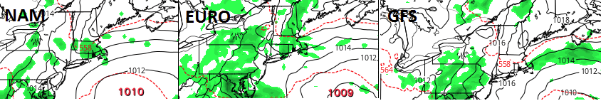
-
May 2024 Discussion - Welcome to Severe Season!!!!
Typhoon Tip replied to weatherwiz's topic in New England
Every guidance except the GFS had it - made a point of it yesterday. The GFS busted fwiw to you -
May 2024 Discussion - Welcome to Severe Season!!!!
Typhoon Tip replied to weatherwiz's topic in New England
Huh? Radar shows light rain approaching HFD now -
May 2024 Discussion - Welcome to Severe Season!!!!
Typhoon Tip replied to weatherwiz's topic in New England
Interesting little short term battle between the this new 18z GFS vs everything else for SNE for tomorrow. GFS is gray but dry...probably a little milder by virtue of being so. Perhaps a little drizzle on the immediate shore points. Maybe some breaks in ceiling out CT and western MA. everything else squares the day into the dumpster with steady light rain shut in weather.


