Typhoon Tip
-
Posts
44,539 -
Joined
-
Last visited
Content Type
Profiles
Blogs
Forums
American Weather
Media Demo
Store
Gallery
Everything posted by Typhoon Tip
-
Front wheel... It's not an EV or even hybrid. But the car's tip top at 160K miles. I've put ... maybe 1200 or 1500 in it in routine maintenance, which went as far once as a caliper/break job which was my fault so not discrediting the car for that. Mainly just new tires when needed, and I was buying low grade ones until I smartened up about that. Those say 10,000miles but you really get maybe 5 before the Mass/state inspectors flag you for interior tread wear or some shit. Better off ponying up for the 30k (minimum mileage), and you'll get 4 or 5 years of inspections. So basically what I'm saying is that I've been very happy with my Toyota. It runs smooth, and handles great. There are minor complaints, like some of the touch screen functionality of the console don't work anymore but I don't need that ...it's certainly not worth looking at new car for that. Plus one of the back speakers can't handle base without buzzing. Minor unremarkable inconveniences. That all said, I am interested in looking at Toyota for hybrid on my purchase. The only trick is... I don't like buying new cars. I prefer to purchase them about 30K with good car-fact heritage documented. I'm not sure that's advisable with battery tech though. I'd go full EV but...I think there's a chance society will collapse and charging might become a problem when/if that dystopian projection takes place. heh. ( some truth to that... ).
-
Heh... Callaway is the set that just blow up on me the other day. Granted, a new/original set pro-rated and all that jazz ... probably makes the old one apples to oranges, but I think I'll test some of the other fruit out there just the same. ha.
-
Summery low... just 63. KFIT's putting up a 80.6 at MW Utah ... so figure that's good for 80 anyway. 10 after 10? They seem to be a warm outlier though. We're right next door here in Ayer and it's 77 averaged among the home sites on Wunder'. KASH is only 73 NAM has Logon hung around 14C at 980 mb ...which having that over an ENE wind is probably also what the model thinks is the surface. Yet, Logan is N wind at the moment and holding - probably doomed to switching on shore. WPC analyzed the BD near PSM at prior to 12z but curiously...they washed it out on this last update. That seems an odd option given our climo, but seeing as PSM bounced up 7 or 8 F when their wind went ENE ( strange)...this whole BD idea by the NAM may have been oversold if the boundary's indeed losing identity and also ...not having much impact. PSM ENE at all of 6.5kts is paltry. BDs being oversold ... that is a contradiction of terms, huh. Right now we dead calm with mid level gunk melting away by the June solar penetration. I was thinking we half had a chance to be strata and 66 with the smell of the ocean but not so much, so far.
-
This BD is odd... Look at PSM when the boundary went through there a little while ago. They actually shot up in temperatures when the wind cut around from NW to ENE 12:55 74.1 49.5 59.4 42 6.9 ENE 29.80 29.92 29.91 Mostly Cloudy 10.00 15000 OK 11:55 67.3 50.0 57.1 54 4.6 NW 29.79 29.91 29.90 Mostly Cloudy 10.00 14000 67.3 62.1
-
It happened twice ... just honing the deeply egregious reality here - I actually also suspect the shorter clubs were costing me strokes here and there.
-
Probably ... yeah ( weird answer; let me explain). An old 'buddy' sold them to me like 7 years ago for 400 - I'm just ignorant enough about Golf attire and equipment, much less anything about proper storage and maintenance, to know any better. So I suspect he took advantage of me. I know clubs can be expensive, I knew that much - so off the knee 400 didn't seem to outlandish. But they were wrong for me. He definitely knew that. And now after some minoring research... there are 9-piece new sets for 300 at Amazon so yeah - So I was treating them like a 'starter set' - just not formally so. I've never been serious about the game. It's something I enjoy, and as I get older, probably will be more serious about it as my various circles and dudes are all mid aged now and it's an alternative to turning ankles doing other shit. Anyway, at the time, I didn't know how old they were. They may have already been used and abused for a longer while. I don't know. Thing is, I used them for several years ( though not last year even once; terrible Golf year with daily dew dripping thunder rumbles it just never corresponded with any free time), off and on... no problems. So this is the part that is related to my ignorance about maintenance. I let them stay in my trunk... hot, cold, hot, cold rinse and repeat. Bouncing around here and there...for 3 years. I think it just weakened the connections at the bottom of the shaft. Lesson learned... the hard way. Could have been alone at a driving range - that would have been ideal. Heh. I can tell you ... successfully getting a ball down the fairway teeing off hole 1 in front of that particular type of crowd is pretty high on my list of priorities... But the opposite unfortunately was showcased - while looking and probably behaving like a plebe. fuck So using the opportunity to get serious. I'm checking places to get fitted for the right club. I'm 6'1.5" and my wrist to ground measurement is 36.5" ...which put me about .5" longer than STD. Unless Golf has some kind of metric for ill-repute, I'm assuming STD means "standard" and not sexually transmitted diseases... Anyway, I spent some time after the humiliation reading about all this stuff and I have it pretty well figured out. The rest is finding a good outlet to pick up where I left off and ... probably going to cost some coin, but I'll just do the 1 and 3 woods to start, and rely on the old irons for a while longer. That 400$ set ? the buddy I was with the other day says they are too short. He's guessing they were for someone closer to 5'8" and probably .5" under STD. ... which would make them 1 to 2" to short for me. Time to get serious if I'm going to do it at all. The guys want to do a regular Saturday thing
-
Occasional Thoughts on Climate Change
Typhoon Tip replied to donsutherland1's topic in Climate Change
https://phys.org/news/2024-06-genius-scale-material-earth.html ... This above links back to a conceptual idea we've discussed in the past ( distantly ) in this thread. Namely, how humanity, has become ( or 'allowed itself to be' more precisely...) too inexorably dependent upon technology, will most likely require technology to pull us back from the brink. It's a race... The above article is an early example of just such an innovation. These kinds of innovation are going to have to keep emerging, because CC is/has already proven to be outpacing the nearly untenable, slower response curve of 8 billion persons - too much momentum to deviate fast enough. See .... this is my personal only response I can come up when I'm listening/reading to the doom-casting of humanity's ( and countless other species for that matter) future. Many of the doom projections, partially negate innovation in the full spectrum of adaptation. 'Can there be invented, proverbial "filters" that control C02, as well as the so-called 'forever chemicals'? * As an aside, we may very well end up in a future state where we've tackled the CC crisis, with much faster returns on success than ever imagined possible; but then suffer the irony of Microplastics - which really is a bad rubric, because the nano-particulates are apparently maintaining structure and that is far worse. Example, they've crossed the reproductive boundary. These "unintended by nature" foreign substances are now being found inside human and other mammalian testicles and ovaries. If one were an investor on Wall Street, and there were ever an option created that bets on the future in such matters, go long on birthing rate crisis. It's nearing criticality... For over a decade, the birthing rate drop off among 97% of the global population roots was believe to be primarily cultural feed-back-related. Now, a growing uh-oh consilience over this discovery's implications is both quite obvious and unsettling... Cross that bridge I suppose. In the meantime, I'm not sure the fuller spectrum of human adaptation is considered. It's understandable why that may not be considered enough. One cannot modulate what is known, based upon what is unknown about the future - not with any certitude. That is like proverb worthy. Believe me, much to the chagrin of whomever, CC and/or pollution are going to doom humanity whether you believe it or not. It's up to those who who rightfully do, to turn the gears of discovery and innovations that can save this thing, in spite of those that believe there are no problems. If new tech can out pace their stupidity, much, much more than just the intelligence of humankind may prevail. -
I'd agree with you but yesterday unfortunately bumps this one to #4 ... maybe #3 if we can all concede yesterday was a 1 or 2er Did 18 holes at Stow "Achers" ( Stow Acres). The sky was incredible. Like peering into infinity under which the air was packed with sunshine in every direction. It was 79 over the open fairways with just enough breeze to not affect flight paths of strokes, but enough to wick the sweat away in cooling reprieves. Not impressed with the course though. They jacked the prices quite a bit while the quality of the fairways was not very good. Greens were only so so and wouldn't play the reads because they weren't cut well - certainly not the for dollars spent. Had a very embarrassing day though. I usually end with a 12 or 15 handicap by the end of the year - it's not a game I'm naturally gifted. Still, it was first out of the season and I ...eh hm, ran into an equipment failure of a most unlikely kind - bizarre. The parking lot was filled with convertible Corvettes to BMW SUVs, of course your pet Merc's and Lexi's, too. I think I might have seen something that looked a bit like an Aston Martin .... and of course, my Toyota Corolla. Hey, it's a "Sport" class so I had that goin' for my image. Which was clad in just an Izod cotton collard shirt over Kaki shorts, and pair of retired running shoes. Just squeaked into the dress code. But in all fairness, it was a 28 year old aristocratic larvae walking around in the 1200 dollar Rory McIlroy wannabe golf attire being the society types they have in mind. And as it were, I was teeing off on whole one. 11:15, ahead of several groups of 3 or 4 of the high cheek-boned privileged, all their eyes ogled upon me in their collective silence so loud I was nerved up like meth head when I swung my 1-wood. Only it would not be my ball that would make it over the immediate water hazard in the foreground, but the actual heal of the club! i It snapped right at the bottom of the shaft...somewhere between the Ferrule and Hosel, sending it over the water. The ball "blooped" in... All Golf nightmares coming to a sudden parallax right there and then upon that fateful moment ... A horror story of humility only made incaculably worse when after reassurance by my buddy, and a moment to gather my composure... I set back up with my 3-wood. It happen again ... I shit you not. Both clubs, in successive order.
-
Occasional Thoughts on Climate Change
Typhoon Tip replied to donsutherland1's topic in Climate Change
I find the suppression in latitude fascinating - not a climate introspective, but for the Meteorology. The pattern foot so far this spring has been limiting expansion, perhaps masked by seasonality. In other words, folks would be inclined to suggest 'Hey, it's only May'. Yeeeeah, but I suspect there's some relativity going on. My personal suspicion is that the background planetary environment passed through a global threshold at some point over the last 10 years - together with some fantastic singular warm anomaly events, when then aggregating those synergistic heat bomb phenomenon together with the early in 2023 total GW spike ( air and sea, everywhere!) ... I just think we're staring at a duh situation trying to understand the specter so vast the boundaries of which aren't yet very obvious. Kind of like a deer caught the headlights cliche ( so to speak..) But maybe given time any such threshold to be defined. Within the confines of that new paradigm, we should be seeing more of these heat expansions prior to the solstice insolation - that's the relativity, in that we may merely be seeing a suppression of that new norm, endemic to this spring. I'm looking at the long lead telecons, out through the third week of June, and suppression of 'big heat' and/or SW expulsion events, N-E of St Louis ( ~ ) isn't favored. Yet if that is materialized in the spatial synoptics ... I have a funny feeling that Mexico to Florida and S. TX ...possibly as high as Dallas to Alabama and the Carolinas from time to time, may swelter while ORD-BOS is mollycoddled with temperate spoils. -
May 2024 Discussion - Welcome to Severe Season!!!!
Typhoon Tip replied to weatherwiz's topic in New England
hahaha... god I love the damage I can cause when rollin on passed with a drive-by posting - -
At the end of the 12z GGEM it parks a -2 or -3 SD mid/ua low over or just N of Lake Superior with a highly curved flow running underneath that subtends clear to ST Louis yet ... 570 dm thickness to NYC ...
-
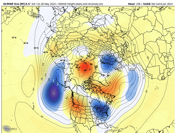
Right. heh And it seems every morning the models are even more aggressively anomalous with creating a butt plugged hemisphere the likes of which would make February's envious ... That said ( "sarcasted" ), I do think there's some possibility that A, the models are over doing it, and B, the lower troposphere may not really really be very well coupled/integrating vertically into those trough meanders - a typical aspect of the sun's enormous normalizing power. It bakes lower Canada almost as much now so it's not like the mechanics are translating abusive fronts anymore. The 2-meter temperatures are still 80 or so in some of these products ... etc.
-
May 2024 Discussion - Welcome to Severe Season!!!!
Typhoon Tip replied to weatherwiz's topic in New England
If it's a fan blade impacting polystyrene ... just think of all the delicious nano-particulates of plastic and/or forever chemicals you'll be inhaling. mm mm yummy. I was reading a paper at Phys.org about the crashing birthing rates among industrial guided societies of the world ( which is pretty much 99% of the global population at this point) as being alarming. A pie slice of the cause is pretty easily identifiable as cultural feedback. Less women being male-reliant are opting out of child birth this ... Cost unbalanced by inflation that. Sense of doom from the perils of pollution and climate change saturating media is causing younger generations to be less inclined... There's a lot in the pie slice. But one aspect that this article covers is environmental toxicity. Study links lowering male sperm counts/potency as possibly related to a recent discovery that micro-plastics have penetrated the reproductive barrier, and now can be found in testicles. You have micro plastics in your balls, men. And it appears based on modeling that there is a correlation (time dependent) between the micro plastic invasion into the background, vs the onset of the sperm potency reductions that began some 20 years ago... and is getting worse. Population controls may be imposed whether we choose to or not, huh - -
it probably wouldn't be as bad as that sort of impressions though. This time of year, the lower troposphere ambience is pretty normalized in all directions ... weak baroclinicity and lacking much gradient below ~ 700 mb, probably lends to much of that just being mid and upper level. Prevents 'big heat' but ... noticing the 2-meter are still 80 or better even when that trough at 500 mb is landing into a negative L/W axis ... To bad there's no early TC off the SE coast, huh
-
yeah. it's hard to get interested or very enthused though when repeatedly the cinemas keep ending up looking like this out there
-
Just anecdotally/observation on my part but agreed ... there does seem to be less occurrences of ridging over the eastern mid latitude continent during summers. In fact, I've noticed more success in doing that in May's ... yup. It's hard to say if this just some fractal at larger scales - repeating until it doesn't and it may take 10 years or whatever. I have a sneaking suspicion though that coupling the geophysical circumstances of canonical western heights, with greater heat absorption spectrum associated with greenhouse gassing, might be triggering the western heights as the summer dominating mode. In other words, coupling/super-imposing those overwhelms... Man... should a Sonoran heat release take place, however rarefying that may be ..., it would be interesting if one of these synergistic heat wave events would take place over the eastern continental mid latitudes - that might get it done. And we'd put PHL-PWM into the VIP class with some of these other locations around the globe filling E.R.s and lighting up social media with conspiracy theories. the latter's been funny actually.
-
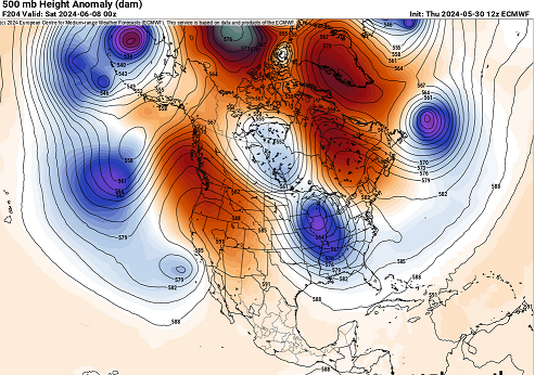
Yeah it's been rough on summer enthusiasts with these models and the longer ranges. Not really ever yet have we gotten a sense there's real heat lurking out there. And what I've noticed is that it's been different on every run - as though no matter how it gets done, 'must not allow heat'. LOL. I mean it's not like there's a coherent recognizable pattern type that's re-emerging every run. The models are spraying out different reasons. Here's the 12z GFS's latest summer cancellation.... Unfortunately, the +PNA/-NAO in the telecon is also attempting to accelerate to October 15, too. Hell, maybe this summer's doomed before it gets going.
-
May 2024 Discussion - Welcome to Severe Season!!!!
Typhoon Tip replied to weatherwiz's topic in New England
This should be winding down soon up here along Rt poopy. It's already either day glow-lamp ceilings if not the occasional solar beam flashing across windows SW of the Pike, but otherwise, the presentation is weakening overall on sat and rad. Long days of summer can have two quite distinctively different sensible appeals packed into the same daylight period sometimes. -
May 2024 Discussion - Welcome to Severe Season!!!!
Typhoon Tip replied to weatherwiz's topic in New England
just nipping the possibility of a spontaneously emerging, misconception phenomenon ( LOL ) in the bud here. It isn't a Landphoon. 'Phoons as a phenomenon are convectively induced vorticity. This thing was entirely synoptically driven with S/W mechanics. Albeit rather nucleated/small comparing phenotype ...but it was still caused by different physics. -
Ha... lol, but it seems like "great - winter's fucked no matter what" being most apropos at this point.
-
May 2024 Discussion - Welcome to Severe Season!!!!
Typhoon Tip replied to weatherwiz's topic in New England
the air smells and feels like that late October vibe. You know how cold air rain types have that aroma? Someone's also using their fireplace this morning too. 51 R ooph. It really underscores just how bad that July 4th 2020 was really criminal -
May 2024 Discussion - Welcome to Severe Season!!!!
Typhoon Tip replied to weatherwiz's topic in New England
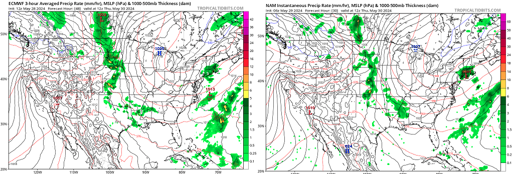
I thought it was kind of both ... It wasn't seen very well until about 48 to 30 hours ago depending on which guidance used, but once it was ... they were all on board that it was getting wet. The NAM ( or any other guidance - ) may have bumped the QPF max around around the region, but in principle the meso-beta scaling aspect of this "little critter that bites" ... that may have been why the shorter lead to be "seen". It is an interesting system - it's entirely impacting only in target kind of frustration. Here are the Euro 48 hours ago and NAM from 30 hours ago, respectively, left to right. ...thanks to TT's "Prev. Run" option. Once these guidance did latch on the event was pretty stolidly situating just about right where it is occurring - albeit ...the model may be low on totals. I'm not sure in the case of the NAM we can really lampoon it's position handling on one hiccup run when we know what that tool's capabilities are.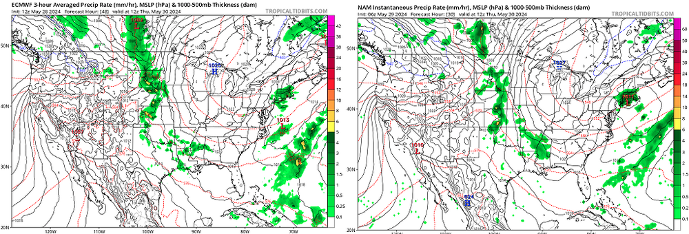
-
May 2024 Discussion - Welcome to Severe Season!!!!
Typhoon Tip replied to weatherwiz's topic in New England
That looks like the models are tapping into winter mechanics for that. we'll see -
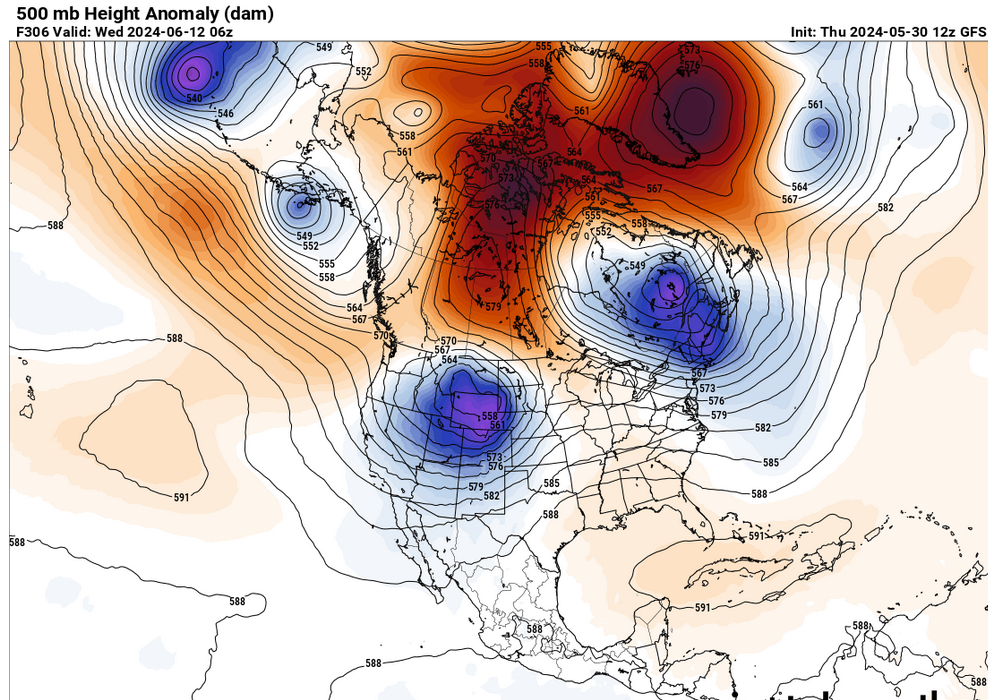
Strange ... the GLAAM outlook from the CF model cluster would indeed suggest mid latitude expansion of subtropical ridging ... (really an polaward HC boundary migration) while the numerical teleconnectors (based off the global numerical ensemble systems, all 3, are going bonkers with this +PNA) - that attempts to deny the +AAM. +AAM modulates away from meridian flow transports in lieu of longitudinal, yet this... And it's more than this just transiently passing through this construct around that time interval ... the ensemble means set this up D8 and run it out to the annular finish at D15 still harboring a hint of the OV nadir there. Bit of a diametric indication going on.