Typhoon Tip
-
Posts
44,539 -
Joined
-
Last visited
Content Type
Profiles
Blogs
Forums
American Weather
Media Demo
Store
Gallery
Everything posted by Typhoon Tip
-
Yeah we've been talking about this for over a week now... I guess we need to see a tweet to be impressed with it? LOL It is interesting to me though, how we can cover a phenomenon until the dead horse wasn't just beaten but vaporized, ...then the tweet rebroadcasting kicks in like its this awesome thing. haha. Anyway, there is a pretty significant seesaw in the Pacific mid latitude circulation mode that's above normal confidence. Above normal because every ensemble system there is not only spatially represent the change, but this is also reflect in the numerical teleconnections. Negative height anomalies N-NE of Hawaii are replaced with positive heights through that region. That heralds mode change +PNA to -PNA. Now... those with a modicum awareness in this field might proffer that the PNA becomes less correlative as we get on with the warm season, and they'd be correct. However, if the shoe fits ... It's not a "0" correlation either. The data is overwhelming when its every source. The operational runs have been variable about what to do with it. Generally display above normal temperatures, but they haven't really pulled the trigger on a big dawg dome. The above symphony songs like its possible, but ...a more tepid result would also fit inside that scaffolding - an ending statement I am sure the KFS model will take to heart and resonate with fully.
-
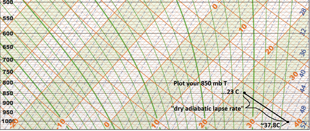
Here's a blank skew-t/l-p diagram (below 500 mb) to assist the sounding/sigma elevation to sfc relationship, provided the atmosphere is mixed to the sigma level. ( (37.8 X 2) - (2/10 X 37.8 ) ) + 32 --> (75.6 - 75.6/10 + 32) = 100.04 However, we are not at 1000 mb sigma as our surface altitude ( sigma is the elevation in pressure coordinates)... You can go ahead and add/assume a higher pressure than 1000 mb, which if you run the dry adiabat for estimating, you'll derive something more like 103 to 104. But here's the thing, the "2-meter" temperature also is typically a super-adiabatic layer on sunny summer days... so that adds a little there too. Art: When I use the T1 temp off the NAM FOUS grid, which is ~ 980 mb at LGA and BOS, I figure that's needs (usually ) lengthening that extrapolation by 20 or 25 mb, which adds 5 to 7C to the T1 temperature ...particularly in and around micro locales that are climate red spots. So 22C at T1, is really more like 28 or 29C over your drive way or walking across the street downtown or parking lots. Like today. 22 C and we're 84 (28.x C) west of Boston of interior eastern Mass.
-
Day drinkin?
-
temp blew up here. bolted to 86 when that cloud deck slipped off a couple hours ago.
-
we were playing disc golf most weekends all winter - it was actually preferably nicer than traipsing around fairways under hot sun... but, the ticks were being flicked off every every other outing. all winter long
-
wonder if this will be one of those summers where this is always on the extended charts
-
Operational runs are backing off the implications they carried yesterday. We'll have to see.
-
Yeah ... I distinctly recall, that was the version of the GFS that was particularly awful in handling boundary layer thermodynamics. Folks might remember that 37/30 during 3" of QPF Nor'easter earlier that March. That storm ended up 33/33 cat paws... but because the 37/30 looked so egregious... many thought ( including self ) that there was a chance that was setting us up for a blue monster. But instead it just kept raining at 33 ... 34. Very frustrating event for late winter enthusiasm. We did eventually get a blue bomb later that month but ...anyway... later in the Summer, that ridge with 606 DM non-hydrostats was putting out those 110s over eastern Mass, in the GFS runs, and as you say, we corrected the DPs up to reality, and that sucked the temps down. One thing about that ridge event/heat ...96/75 -like, there was no and/or only very weakly coherent SW heat mass release. I've always maintained that we might have been robbed our 'Pacific NW' notoriety but the fact that we had to home grow heat and not get the table set gave us towering heights with room to spare..
-
Nasty heat wave on that GFS run
-
Wasn't paying attention but it's 75/70 here with sun now coming through now.
-
Right ...and the end game is open ended ... From this range that far side of that is beyond the 'probability horizon' - it's just an expression I came up with to describe the temporal boundary, beyond which is equal probability for any given result is even. N/S ( no skill ) as it were. Depending on the pattern contention/degree of confidence - which can be derived statistically tho complex - determines that range. You can sort of intuitively see it though... In this case, every source that provides telecon spread, unilaterally neuter the PNA and now are tending to even reverse into a negative ( though modestly...) beginning in 6 days and then knowing model error in general, sort of sells the pattern evolution toward that look on the front side for low money.
-
Classic Sonoran/SW heat release phenomenon in the Euro
-
Heh... helluva signal materializing now in the operational compendium. They're all over 590 non-hydrostats spanning over the eastern mid latitude continent beyond D7. 588 dm canonical big dawg is broad and expansive and N of our latitude. Heights approaching 596 in anticyclonic axis over WV ... Wouldn't concern too much with details ( obviously ) at this range, if the gist of that scaffolding is correct, that's going mean the biggest heat wave we've seen up here in New England in some years - at least per my own recollection.
-
I don't know how anyone would be daring to assess anything less that hostile hot or inimical to winter ever again with the way CC's not only winning in that debate but flogging heads with its trophy. LOL
-
Could use rain here at this end of Route 2. We just spanned 5 consecutive days of near or over 80 days, with low side DPs, under and anomalously obstructed insolation. During solar max, that's a rather high evaporation rate. Ground water is still elevated no doubt - but just for surface purposes.
-
Must just be unlucky. Haven't heard any thunder around Ayer Ma in 3 or 4 weeks.
-
Looks like there's a new kid on the block https://arxiv.org/abs/2405.13063
-
Really 68 dp?
-
I know you mean well here but unfortunately it won't work. I've tried and tried and tried to penetrate that mind with this and other bits of methodology, as well the general frivolity of attempting to do so anywhere E of the Hudson ... It can't be done.
-
Occasional Thoughts on Climate Change
Typhoon Tip replied to donsutherland1's topic in Climate Change
https://phys.org/news/2024-06-global-humans-high-scientists.html -
Remember that little sci fi thriller by M. Knight Shiama romma lomma ding dong whatever is name was spelled, called the "Happening" ? Basically, the plant fora somehow gets a collective consciousness, one that's had enough of human bullshit and decides its time to eradicate them. So one fateful afternoon they begin releasing some sort of unknown or undetectable toxin that drives people immediately to kill them selves upon inhalation. I like the concept in principle but it didn't really translate very well to the cinema - at least that version of it. But because I like dystopian themes as an accomplished sci fi author, that sort of biased my grading and I gave the film a pass. Anyway, this years choking pollen issue was reminding me of that. heh. I was all psyched to pull the cycle out of the shed, tune up the chain and air the tires... and hit the bike paths... but earned 3 migraine head episodes and irritable attitude syndrome, along with prickly madness attacking my upper trachea for 2 or 3 days for my trouble. Pollen can be f'n toxic man.
-
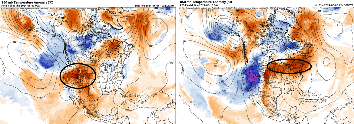
Kidding aside, there's some suggestion there. "Increasingly concerned," that may actually be a little too strong for current indicators, but this/may be yet evolving. There is rising NAO (of uncertain ending magnitude) with falling PNA ( also with uncertain destiny), both occurring on the aft side of +PNA that has a much higher confidence of collapsing to at least neutral That's close to the leading signal for a warming ejection E over the eastern mid latitude continent. In concept, the antecedent +PNA traps Sonora-NM-AZ-SW TX region under a sun that by virtue of those environment(s) the air mass is very highly proficient in energy absorption. Plus, the regional sigma ( elevation in pressure coordinates) places that air mass at a particularly useful altitude for mixing with the lower thickness during diurnal expansion once that air mass is displaced and/or expanse E (evil foreshadow). That's the prep work... but then... as the mode of the +PNA relaxes, releases the trap ...and synoptically ejects that highly kinetically charged air mass out of the SW. If/when the circulation mode of the +PNA --> -PNA is well-expressed ( the non-hydrostatic heights balloons over the eastern middle latitude continent), as said kinetically charge air mass is injected into it. The higher non-hydrostratic heights, being symptomatic of DVM at mid levels, lower clouds and adds a compressional aspect ... high solstice or near equivalent high insolation... this/these combined metrics are climatologically shown to produce extremes of temperature ( + ). Lately across the globe, where there are other recognizable heat transport routes ( for example, the Saharan air layer injection over the Gibraltar straight/western Mediterranean gets caught up in a western European mid and u/a ridge expansion. That is how the British Isles down to France and Spain can cook ), these have been over performing. Modeling may signal a much above normal few days of temperature, but what results is both longer in duration, but maximizing above the guidance suggestion. These so called 'synergistic heat waves' ( papered ) are recognizably increasing in frequency. There have been heat waves across the U.S. every year ... but only 1995 and 2012 are rank-able among these types, and these predate some of the recent hyper extremes that have been occurring. Are we do ? As far as our local region, we have not experienced this here in New England since perhaps 1975 on a single day, but given to the shortness of duration as provided by a brief/transient synoptic circumstance, it seems that was a 'spike' outlier that may not fit the above compendium. The next time one of these sets up across the Nation, there is probability that it will be unique
-
Ah ... not sure y'all got that quite right. RONI is actually a colloquialism for Pepperoni, a variety of spicy salami-style processed food made from an amalgam of cured pork and beef, seasoned with salt, paprika, chili flakes or cayenne pepper, fennel seed and garlic. The term was long ago formulated amid Americana for its delectable inclusion and is therefore most useful in that culinary application and recognition. So tired of misnomers
-
Looking at the stream lines ... NW flow at mid levels with this sort modest but increasingly wet SW flow taking over the region underneath does look interesting for some organization of updrafts. Hail?
-
Shower with big drops coming through ... Satellite suggests this is a cluster of elevated/nocturnally driven convection .. which in theory it dissolves as the sun pummels the cloud tops and kills the radiative -related cooling mechanics... [ blah blah enter popsicle headache here ] I was watching some local forecasters on the TV at the gym at 5 yesterday and they had 86-88 F for highs today. Three towns away I'm sure one would say sure... but here right now, it may as well be a bad camping trip feel out there. The same sat loop, combined with what typically happens when these nocturnal convective decays ... both would argue we're partly sunny by 10 and this is a memory, but... we are putting some theta-e into the boundary layer. SPC has eastern NE in Marginal ... Just some morning obs -