

Typhoon Tip
-
Posts
43,384 -
Joined
-
Last visited
Content Type
Profiles
Blogs
Forums
American Weather
Media Demo
Store
Gallery
Everything posted by Typhoon Tip
-
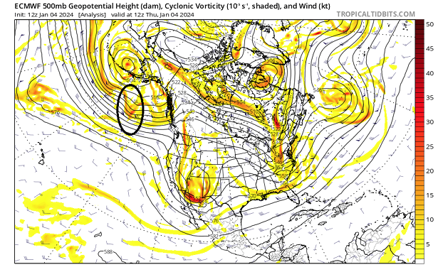
Do you know that the "2nd S/W" in discussion is still out over the Pacific ocean as of the 12z initialization ? yes sir - That ovoid piece there has to rise up over that shallow ridge axis along the coast, then careens like a bottle rocket all the way around the underside of that S/Wern quasi closed trough while it's opening up and smearing out down stream ... Lot of moving parts and pieces being handled over the next 30 hours. I thought this was on-board as of this morning but when I checked I was flat wrong about that assumption. That's it there. Folks should go trace that themselves...
-
Heavies QPF happens during/because of greatest intensification rate - let's do this!
-
Then to have an inversion cap all wind from getting down next week? sign me up -
-
It's easy to see why the NAM did this... It held onto the lead S/W by fractional amounts, and it's causing/pulling the low to escape east before the capture deal ...it does but that hesitation is crucial there. It's basically re-introducing destructive interference. It's counter intuitive but more is actually less in S/W tussle. It the lead needs to attenuate so the 2nd can capture ... however we wanna say it.
-
Well .. not trying to be a wise ass buuut, nothing's "locked" in a 72 hours in a 'needle thread' pattern. subtle movements in the last 18 hours can move a rain snow line N or S by 40 mi, can short term bust a forecast. That said, the air mass on the front side of this thing is cold. The DPs even out over the low GOM waters are < 25 F, and its cold in the vertical. I think that fights back as we get into the 36 hour window and we start seeing models collapse to a chillier boundary layer. I think the correction vector on the thermal is on the cold side for this one, but out of deference to the model... the short answer to your question has to be no - not locked in.
-
Ha ha No but I mean literally it ... the analysis effort is draining after awhile. Hell, even NWS gives their employees 16 hours a day to do other shit...
-
I thought the 12z was dubiously warm in the lower levels to be honest. But it gets exhausting chasing the perfect scenario with plausible excuse after excuse every 6 hours lol. Just letting these model runs come in at this point.
-
Good ...maybe it'll translate to less warm intrusion during the first half of this thing for NYC-CT-RI
-
Now this is a west loading -EPO
-
I mean this thing's got a ceiling folks. I think we've kissed it with some of these solution over the last couple of run cycles. Probably we're bouncing at this point forward, with some runs less and some run back to this ... but there is an upper limit to what this thing can do given the input.
-
Can't keep upping the dosage
-
Two Mdt to high impact events NYC subforum; wknd Jan 6-7 Incl OBS, and mid week Jan 9-10 (incl OBS). Total water equiv by 00z/11 general 2", possibly 6" includes snow-ice mainly interior. RVR flood potential increases Jan 10 and beyond. Damaging wind.
Typhoon Tip replied to wdrag's topic in New York City Metro
Would it be the first time an NFL game was delayed due to ligntning in a snow storm ?- 3,610 replies
-
- 1
-

-
- snow
- heavy rain
- (and 5 more)
-
Waiting on the Euro before signing on the dotted line re major event - didn't like it's comparatively paltry performance overnight but every model's allowed to take a nap on a system for a run or two just the same. All other available guidance into a blender pours a cup of low end major criteria impact. As 'Wiz pointed out, duration may keep a major system to upper tier moderate impact. Really a matter or 2 or 3 hours of difference there - Somewhat multi-faceted: snow ... particularly on an unrehearsed civility. It's been a unwinter-like and probably that lack of testing can be dated back a couple of years. HFD to Boston's western subburbs choking to 14" in a rapid fall rate is a regional scale - it's not the same thing as a couple of towns here. wind ... shores and to some short distance inland through snow loaded infrastructure inducing power outages.
-
Thunder's happening in this, no question.
-
OH you and I are golden here. It's not our complaint privilege on this one -
-
You're psychologist would be proud of you for rehearsing that self-control over your depression management without intervention of Librium - lol
-
did anyone ever check the CIPs analogs? that 12/9/05 system - you know we talked about that last week, but it keeps reminding us of it. Might be worth it to check.
-
Imagining an NFL game called not for the low visibility snow but for the lightning
-
Yeah,... I realize you're rooting for that and attempting to will it into reality ( lol just bustin') but in all seriousness, I'm not sure that doesn't triple point. But even if it doesn't there's enough cold leading and boundary layer drag to lift the wind off the deck. That doesn't appear to be a well mixed momentum to the sfc type of deal - at this time. It can change between now and then
-
So tfwiw, I just looked over the NAM It's clearly more powerful with the resulting S/W product that it then moves under Long Island by 1 to 1.5 deg lat. That's a climate-based signal for the HFD-BED for one. But, it's not even as linear in structure anymore; it's flat out negatively tilting and closing a 500 mb isohypses - What's interesting is that it's sans the WAA snow burst on the front side in lieu of just correcting the whole storm's ferocity/expression from 12z Sunday throughout the day.
-
The issues aloft you mention, notwithstanding ... the bold appears to be the bigger constraint when negotiating p-type ( from what I'm seeing). Firstly, the storm's synopsis and features may be too far NW-N? It's been discussed in the past ... the NAM tends to have a NW bias over the western Atlantic Basin with handling coastal cyclogen and subsequent tracks - particularly outside 36 to 48 hour window. In addition to above, there is also a known tendency for systems of more than less S origin, to bump N as they move into shorter ranges. Those are two disparate error considerations. This run of the NAM strikes me as logistically having both those issues questionable. Or not, but the point being, ...since they are valid I would be careful.
-
Not the 10th/11th ... 13-16th has a greater potential for an east correction. Vague at this range (as yet) but that period should be watched.
-
It appears the American models are coalesced ( more than less..) overnight. Everything is on board and pretty well accounted for sounding-wise. This doesn't mean there won't be instra wave tussling in the trough dynamics as this open wave system cuts through, but by and large those "giga" changes won't really ( well ... "shouldn't" - famous last words!) realize much difference to the end results. Looks like a lower ratio snow S of HFD -NW RI to Boston and the N. Shore, with rising ratios pretty quickly in the interior. Some rain for a time in that region, prior to subtle wind backing with deepening low, cannot be ruled out. The region from BDL CT to BED MA could be a jack pot where crossing up QPF with higher ratio/colder profile. Both the 12km and 32km NAM are interesting at a closer analysis of their cinema of the event. After an initial WAA burst of snow there is a relaxation for 6 or so hours ...then Sunday between 12z and 18z there's coherent reinvigoration over the N-W arc of the circulation, along with both a hesitation in the sfc low, and 4 or so additional MB deepening. This appears to coincided with the arrival of the left exit region (provided by 2ndary jet maxim) passing over the vortex and most likely causing an excitation of the ongoing event during that window... I wonder if there is a brief pulse of wind concern coming into the coastal zones, where at that time there may be sticky snow loading and gusts to 40mph/associated CCB genesis upon exit. The global models may or may not illustrate that kind of discrete look as above, but the genera of the synopsis/blend/consensus are not exactly refuting what those higher resolution meso models are doing. I'm curious if the RGEM is doing something similar Sunday morning.
-
I told everyone the next run of this model was likely to go large late last night... I explained why in a small paragraph - I mean with the tsunamis of posts though... Anyway, I feel pretty good about not getting missed at this point. If something like that were to happen it would be a blind-sighted bust
-
Yeah, I don’t know… With a growing consensus heading another direction vs the CMC’s track record … that’s a bit of a buyer’s beware solution


