Typhoon Tip
-
Posts
44,568 -
Joined
-
Last visited
Content Type
Profiles
Blogs
Forums
American Weather
Media Demo
Store
Gallery
Everything posted by Typhoon Tip
-
Yeah .. truth be told - I sense this is 'borrowed time' over here. I think we're regional neighbors? I consider you, Ray and myself as a kind of forum neighborhood.
-
It really is remarkable... I have only seen a single handful. I spend a considerable amount of time outside. Either golf, or disc golf ...working in the lawn... just hanging out. I'm outdoor oriented. Maybe they en masse have some sort of preferential migratory patterning that is lesser known to entomology. huh I mean I'm not complaining. LOL. We just had a good 2" soaking too - not buying the argument that it's related to background aridity because frankly it's never come off as, as dry, as the dystopian meme/fad has been framing anyway.
-
We should be able to see some interesting TCU structures today. Not sure how organized anything would be given synoptic ... It just looks like murk, warmed by the sun, bubbles up into pulse variety. But that can be locally fun for cloud gawking.
-
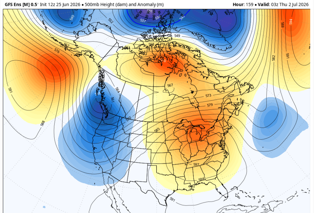
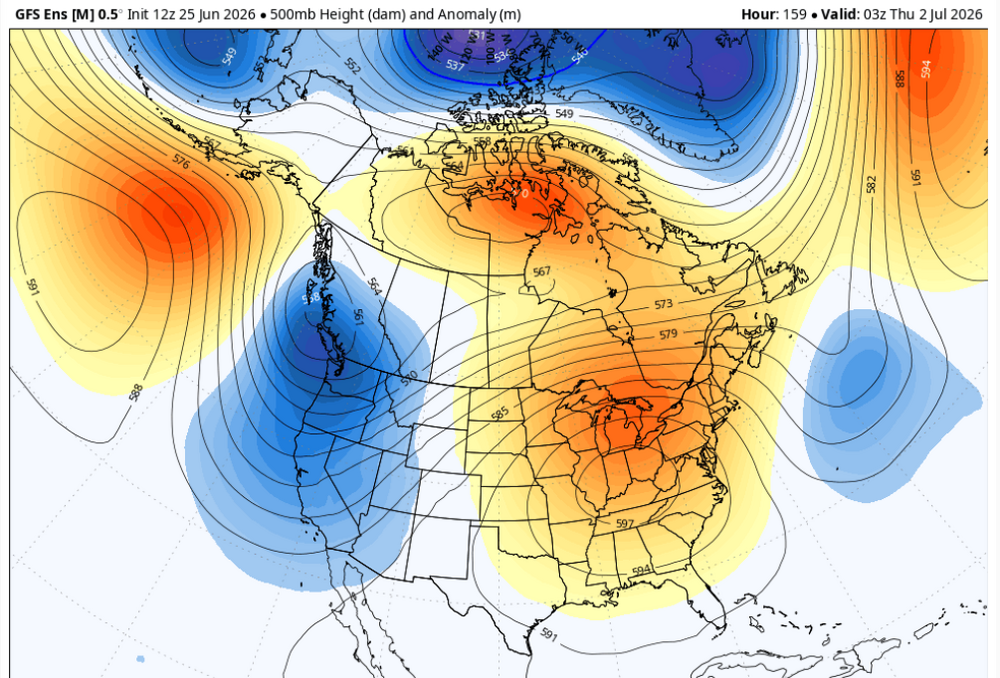
Any nit-picked plausibility that's been used to try and abase what is a clear, apodictic implication, notwithstanding ... that 00z operational Euro run fully committed to a heat wave later next week .. LOL At least at 500 mb... This is not "too far west". For heat enthusiasts that was a legit concern, but per this run, you'd be safe for bigger anomalies. And it's 3 days of it, too. D7
-
Like I said, a very small movement in the total mass structure of these featured layout cleans things up quite a bit. We're on the edge ... this, below, doesn't suggest heat can't get in here. But yeah, it's also close enough that some form or another of a SW calving ( which does happen as part of our climo - ) S out over top would present challenges to getting warm here. And agree on the MCS stuff given this config Too early to call either way. The continuity of the models isn't good enough at this range for having small room for adjusting.
-
It's been awhile since we've seen one of those nocturnal strobers running through southern VT/NH into NE Mass. 1990s had a few. Then...rather mysteriously, they went away. or the frequency just dropped dramatically
-
It's good analysis here but I would also caution for the other readers that this ridge's morphology has been somewhat unstable in the operational guidance - their respective ensemble means have at times actually implicated a warmer/less perturbed scenario which is interesting. I'm also noticing the end game has been correcting toward a warm numerical telecon values, so there may be some question about the rapidity in which the pattern breaks down - tbd. But as is... right. GFS has a stationary boundary dangling through the region heat never gets in here. Wouldn't take much of a bump and this cleans up considerable.
-
mm... it was like this in it's 00z run, too. Maybe not quite as extreme, but it's an east outlier with the 500 mb total placement of key construct when comparing pretty much everything else. "Some" would probably be wise to bear that in mind ... that, and that fact that this model - as far as we can tell - is actually an ICON of shitty forecasting technology
-
mmm one gets the distinct impression that model's attempting to limit or abolish heavy rain in the foreground, then, limiting any heat E of the Hudson ... leaving only the iffy hit or miss convection signal - which will be cleverly biased on the latter side of that chance.
-
For heat enthusiasts ...this is your problem for next week
-
heh 12z GFS is no where near the NAM's idea. Having seen that...I gotta lean on the NAM being the NAM N-W bias at 60 hours. If this were circa November 20th and we were in the midst of a cool snap anyway whether there's anything on the charts or not ... Ineedelectroshock posters of the forum would be presently representing their razor sharp objective restraint by going hee-haw hee-haw galloot galloot galloot over this NAM's 6-10" warning snow event, having fully considered and judiciously constrained their emotions over the matter .... Maybe the Euro or some other model supports.
-
I have an irrational fascination with floods. Not sure why...as it's morally ambiguous to gawk. But they're an amazingly powerful force - too much so perhaps to resist. A truly, truly awesome specter to behold, when even a small brook swells to a 1:500 year return rate raging Amazonian rival... to the point where a Town Hall's annexed church's steeple has a cat clinging to it for life. When a orbital survey of the land clearly suggests it was always some sort of alluvial plain - like the Mississippi Valley, 1993 say... Gee, let's construct a civility there! weee When the Louisiana Purchase took place ... the parting gift to the purchasers ( in this case, the U.S. Gubberment ... why - ) was a bit of advice by the retreating French: "Attempt no city there". But "Americaaa FUCK YEAH!" thought otherwise I suppose.
-
watch us get a 5-7" un-forecasted rain bomb out of nowhere by training 55 dbz rain cores in along a linear band of 40
-
New NAM bringing overrunning big rain potential suddenly for Saturday. We'll see what the other soon -arriving guidance updates show. could just be a typical NAM too far N-W at 60 hours deal.
-
Occasional Thoughts on Climate Change
Typhoon Tip replied to donsutherland1's topic in Climate Change
One aspect that intrigues me about that final/ending statement, "While our findings provide many avenues for interesting and relevant new research, the authors stress that the best way to reduce both uncertainty in and exposure to climate impacts is a rapid transition of relevant societal sectors away from fossil fuels to stabilize global temperature rise", is that the climate response has actually lagged behind the anthropomorphic contributed forcing. Or in other words, the latter has outpaced the former. I keep reading statements - no fault to the author as it's not specific to their study - like this, where it "seems" or intimates a 1::1 causality in time. As though if the ideal reality could ever be achieved, where there were a sudden and abrupt cessation of fossil fuel use, there would thus begin an immediately response and stabilizing climate. That is unfortunately not the case. In any such idealized state of affairs, the Earth would like keep warming until it satisfies the total thermal regulation/balance. Another way to look at it is, there is room for the present atmospheric chemistry to store yet more thermal energy that it is. Another possibility ( intuitive speculation) is that the modulating aspect of the global oceanic quasi coupling to this mess we are in, might also continue to absorb the lion's share of the warming human activity should otherwise have realized. 90% of which has sunk into the oceans (btw) since the Industrial Revolution. So in simpler terms, it's possible that a sudden stoppage of fossil fuel combustion might register more slowing of the warming due to this factor. -
2026-2027 Super El Nino
Typhoon Tip replied to Stormchaserchuck1's topic in Weather Forecasting and Discussion
I'm not sure if this is objectively true but this does seem "intuitively" to be quite fast for an onset differential - coarse kind of resolution/presentation as it may be... What's the average modality timing with these things...etc
-
has anyone else been receiving occasional report backs with Gate way lag/failures. It's saying it is at this end, btw. American's problem if the report is to be believed.
-
haha... Brain... no, Brian
-
I'd actually say 50/50 shot that the westward sudden retrograde idea around the 4th to 7th of July is too aggressive. As I said to Brain, the purer derived numerical teleconnectors, from all sources, are graphically not really propagating the rising PNA curve closer in time. Repositioning them toward the right on the graphs means any retrograde is been pushed back. I think what is more telling about that isn't a pattern flip, it's more a pattern uncertainty. It's like the modeling tech et al loses the linear more detectable physical forcing in the nearer terms, then that immediately exposes the vestigial perennial non-linearity of the N/A continent favoring higher heights over the Rockies.
-
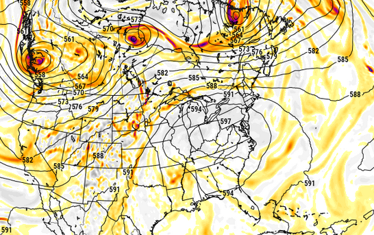
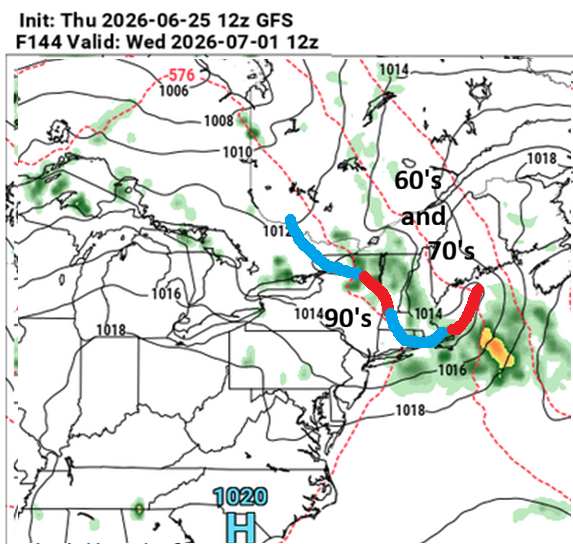
The GFS actually hangs the warm front right over us for 2 and half days from what I see. A time in which IL/IN/OH/MI enjoy 582 to 584 dm hydrostats containing 25+C at 850 mb plasma layer, over 102 F surface blister. It's related to that stuff we talked about yesterday ..it's stacking the ridge heights uber tall, but keeping the wave lengths pretty short - does seem a little suss but who knows. I see what you are saying but the GFS is trying really hard to keep the wave ( holistically...) lengths so curved and steep that it collapses the ridge's giz pulses more S than SE. E NY/PA and NE ends up more just humid and thundery and probably MCS traffic cops. It's a form of summer weather for sure... But just my take looking at the 00 and 06z blended GFS operational runs. Having said that... what's interesting is that the GEFs/GEPs means are actually cleaner looking than the operational versions of either cluster. That in and of itself is likely just smoothing from the member tussle/averaging.. .but, it shows also that this is precarious, because those smoother inclinations actually would send an over top heat crest in a couple of 18 hour separated maxes... (too detailed to make that call, but I have long years of experience at this point). Interesting. I'd say the ens means look more more "successful" in the over top method. Of course, still D7... The blend of all looks high confidence for the southern GL region to suffer a short duration very intense heat wave. No comment on historical this-that comparisons for now. Regarding that, those 2-m Ts do not look correct given the holistic, synoptic- parametric constituency that is objectively modeled. Not unusual though - not sure why 2-m products really exist. It is clear they either stop the adiabats at something higher than the surface sigmas (thus can't be 2 meter anything...) or just suck too bad to even look at them. So .. short duration? I only say that because even though the ensemble spatial synoptic means can't seem to wait to toggle the entire structure dubiously quickly back W...like within 2 days flipping the PNAP on it's ass, I'd caution, the numeral teleconnector ( math provided numbers) are having difficulty getting that nearer in time. They are collapsing the wave function ... think can kicking, which means it could be rushed.
-
It's flawless imho today.
-
Yeah I've had a sentence floating around the internal monologue lately that sums up ... "we seem to just be geologically incapable". I've been following heat waves since before the "synergistic heat wave" was identified ( recently decades) as a real track-able phenomenon, and since they have ... we've gotten our "heat waves" but ... I dunno - it really doesn't seem like we can do the synergy thing here. The wave spacing miss-alignment with the continental girth during seasonal contraction of the r-wave lengths idea seems to be the best fit that I've seen, too. Same. I was thinking that very same thing, we just need some very rare/long return rate timing perhaps. Maybe it's 1::300 year deal here. Or, it can't. At this point it's been 23 years since France and we've seen 610 dm high ridge nodes recurring everywhere it seems except here. Hell, Japan's had one or two.
-
Occasional Thoughts on Climate Change
Typhoon Tip replied to donsutherland1's topic in Climate Change
sort of a secondary statistical remarkable nature here in that since these records in some cases are back-to-back consecutive days warmer than the prior record means that the aggregate exposure of this is unique. It'll make the integrated heat wave energy probably a GOAT -
Western Europe is now five of these nuclear synergistic heat bombs since 2003, compared to our zero spanning the same years That being the case when there is a codified positive correlation tele connector between eastern North America western Europe This is somewhat odd
-
https://www.instagram.com/reel/DZ-BVyWRCWR/?igsh=MWdyeHVhZ3BjczRueg== LOL