Typhoon Tip
-
Posts
44,523 -
Joined
-
Last visited
Content Type
Profiles
Blogs
Forums
American Weather
Media Demo
Store
Gallery
Everything posted by Typhoon Tip
-
Two days from now that will be back the other way ...
-
- random thought ... Maybe since 2015 ended ... we are in the 1980s - I mean, not as systemic analog, necessarily ...but in the synergistic sore-butt propensity and pure bad lucktitudeness
-
Yeah ... all that, and .. what are y’all really grousing for ? is it because the winter May be uninspired, or is it because there isn’t an idealized imaginative hyperbolic pattern in the models like right now.
-
It's part of it ... meh I don't think it's really about 'snow' as much ... not anymore. It's about the rush and possibility. Seriously have noticed that in-storm tenor change .as though the run up and the modeling was what folks wanted to savor in - once it's snowing ...the fervor seems reduce. Folks want and perhaps per deprivation ...need, a kind of 'giddy' mood surge, breaking toward joy happiness ... and when they set the coffee or water down in the morning and see a thread blown up by 12 pages over night, and big wound bomb on the charts ... they don't abuse their children that afternoon and evening... Kidding, but it's more about 'excitement' in general? There's even a kind of dependence on it...
-
Actually the 12z Euro (oper.) is within the margins on that ...
-
Lol...omg - it's true though... We see this so often ... gotta get the mood so low as to challenge the very endurance of man ...and then and only then, viola... We're a p.h. from glory right on cue -
-
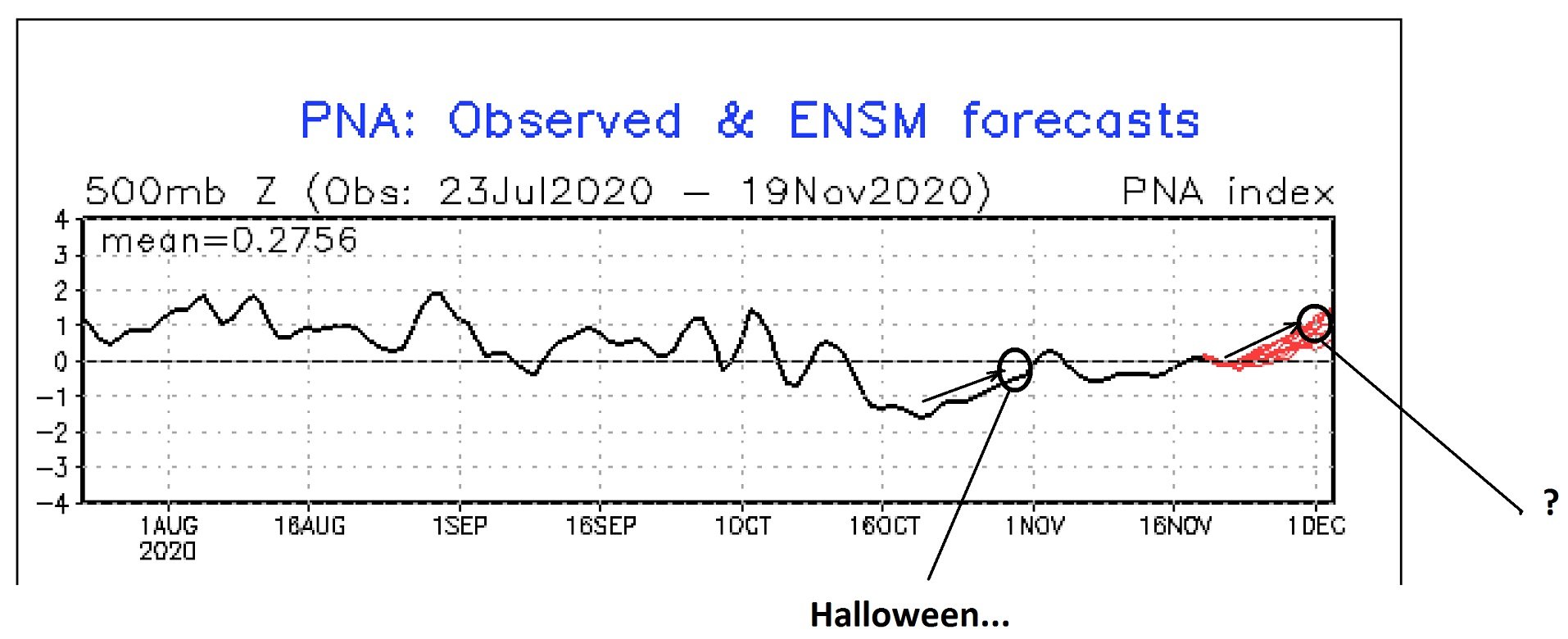
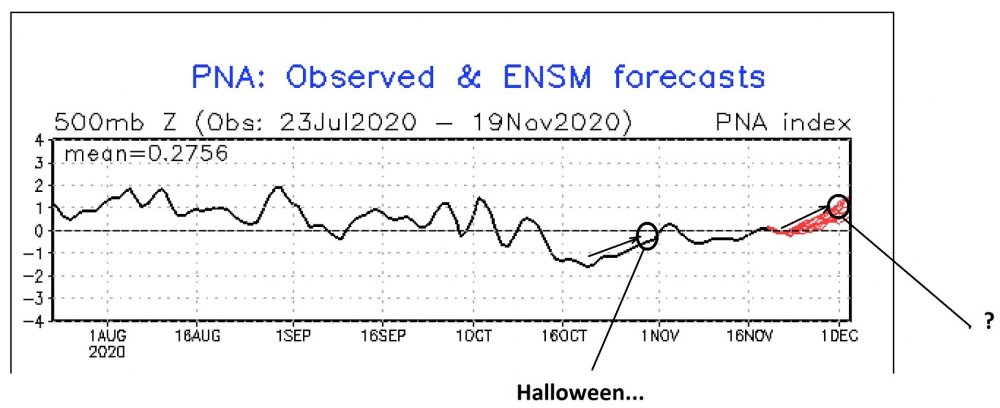
well...I'm not sure it really can if the PNA is doing that ... but it is just the GEFs... ha but anyway, I forgot about the weird events around Halloween with that ordeal ...may not be a corrective event but, the cold loading into midriff Canada and ultimately servicing the cold for that snow event was delivered by a PNA mode change as I just suggestively annotated ...and it seems this next modality is well agreed upon in said GEFs ensemble members/mean ... It's interesting -
-
-
You know ... as an afterthought on the PNA - definitely want to see the EPS take on the mode/modality of the PNA because if looking back along that curve... smoothing out bumps and do-dads ...the 5-week trend, all the way back to mid October, is up. It may be doing so too gradually to 'ignite' a larger -scaled correction event ... or, just not enough to 'trigger' one ( yet )... like when the it 'spikes' and so forth. But, that's interesting long term trend line there...
-
Couple of aspects I like about this guy ( the D7.5 thru D9 time range) ... The limiting factors is ...as I noted briefly an hour ago...the the fast progressive nature of the flow. The western ridge/eastern trough, doesn't have time to reach full wave amplitude before the larger hemispheric scaled momentum has pushed the whole thing along ...That's why the GFS ends up with a open bag of 'almostitude' ... Not worrying about that though at a D8 ... let's get some sort of dependable table setting first ... Which related to that ... I don't wanna fall for this shit again but ... ...that rising PNA is yet even more concerted and demonstrated out there around temporal seam of weeks 1 and 2 ...which is right about on this western ridge amplitude ( requirement...)...thus, some correction toward taller heights over western N/A isn't terrible as a 'correction vector' ( if you will...).. If so, the flow probably slows concomitantly down and gives the surface/cyclogenesis time to coalesce and come into form for a strike..... The GGEM is encouraging ...not for details ...but I am a big fan of cross guidance support - EPS derived PNA = ? .... The operational Euro is noted but the EPS seemed to be more prodigiously interested ...hinting/grudgingly more western heights post that trough ejecta so ... you know, we're not around inside that Euro D4.5 wheel house...and the EPS could portend a future correction.

-
It's a blown open ravioli .... it's a result of the flow outpacing the cyclone kinematics - I mean it takes time the physical interplay to evolve the storm, but if the whole construct is ripping along... particularly at this sort of range in the guidance, it starts pulling/tearing at it...
-
I wasn't honestly paying attention but that 00z Euro's D6 solution up there is a humdinger ... that's bordering on excessive bombing rates going from a 1004 mb low over PWM to 967 mb over the NF region.. Like Will just said ... roll the die on timing for NNE I suppose. That's prooobably light snow in the air moving sideways at commercial airline take off velocities for Caribou Maine, with one helluva dense arc of blizzard rad just NE of there on that 00z Wednesday chart. So... maybe we should qualify our uninspired 'putrid' look to be in deference to our region specifically. Having said all that ... I don't see this as very likely buuuut, D6 is far enough out in time that a southwest correction could ... oh, hell- sometimes the jig is up and god can't get away with his/her bullshit anymore
-
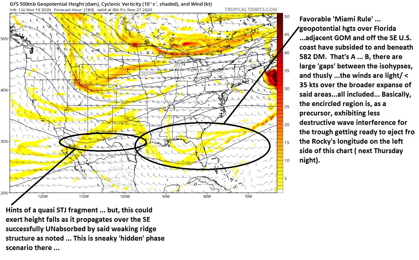
I looked at the Euro ... and it really is banal for everyone who seeks excitement through this kind of cinema. It's really just uneventful. With a quasi-zonal flow transiting waves that don't host more than fropas. You really could engage in something else and not miss anything. I'm noticing the heights from Brownsville TX, to Miami FL to off the SE U.S. coast are unaware of these waves as they ripple over top. The GGEM ... it has a suggestive look there at 96 hours but then the trough structure succumbs to the southern height wall... as the trough gets absorbed. The northern aspect rolls up into Ontario ..and the vestigial southern aspect slopes positively backward about to extinguish altogether. Bit of Miami height rule working its destructive wave interfering magic there -
-
Amazing diurnal might be underway. Probably the temperature rises right thru midnight (12am) and we bootleg the high late. Could be 55 F at that time. I wonder if we'll even decouple much tonight in this Euro synopsis. Quickening WSW gradient flow through mid troposphere may battle the long night. Interesting micro-study chance there. In any case, this is the 3rd time we've seen .. or will, a 48 hour complete abandonment of winter profile in lieu of early autumn. I almost wonder if this may typify the winter ... big profile roll-in and roll-outs. But today is a fair-weather version of that Jan 94' thing Will and I've mused about .. The day dawns blue-tinted light, the region bathed in sting cold, ...the kind where you don't dare slip bare-handed while lifting the car door handles or your knuckles will never forgive you. It was 9 F at the time. It was 60/57 F, with 52 mph gusts from the S as the last observation for that day, just before flipping over to the next ( 11:59 pm) ... while the winds ripped steam apparitions off corpse of the snow packs and street-side piles ... murdered by winter's abandon. Anywho we managed 16 here ... Interestingly, it was 25 at sun up and is 31 now.. The 850 mb must have begun warming enough to begin radiating some warmth into the column via conduction? - kind of interesting. Low was registered at 3am with still four hours of darkest before the dawn though, under naked, starred firmament. We should have have made 9
-
It could also be the enhancing gradient/baseline sped up jet/westerlies too tho. I mentioned this to Will earlier but it’s the same process ... not just over the PAC but in the total hemisphere… The increase wind velocities cause the heights to fall on the polar side of the flow it might be causing the arctic oscillation to bias positive and that would cause heights and temperatures to lower within the Vortx the strengthening the PV
-
It's interesting .. that screaming Pacific jet/compressed isohypsometric layout out there is the culprit - 'mean, ...not that you asked, just sayn' But that flow being exotically quick from mid Basin to the west coast would concomitantly lower heights on the polarward side ( Navier Sto ftl ...) ..and that lowering impells the PV to slip off it's kilter and reposition there. I don't know/think that could be stable that way ... but...I'm not sure frankly. 1982 had that Atmospheric River - but that year was definitely a Nino year, air and sea... This year is some sort of anachronous nightmare of doing the physical impossible now, when it's suppose to be otherwise apparently -
-
so what are we dancing around the notion of here... what's the elephant in the room, 'cancel thanksgiving' ? like, any house with more than a couple cars parked out in front gets a run on by the local pd like a noise complaint at a frat party - ... just getting ready to cut the bird and its, 'bang bang bang' at the door?? heh. anyway - I heard there's three ( now ) sources for a vaccines, including Pfifer .. I don't know what these other two are or if this statement's even true so don't quote or assume or start a fake news meme or nothin' just askin' - is it true. The way this was said, the other two are not as logistically difficult/fragile with their version - and together... all three estimate 26, 000,000 doses available to the upper 1% of the global population by Jan 1 2021 ... j/k...but it was espoused that they'll have that many doses -
-
The following doesn't mean anything .. nor is intended to imply anything substantive, but I think it is interestingly ironic - just the symbolic nature of what's gone on in society over the last 3 or 4 years. What happened ... ~ 18 months prior to the outbreak of SAR CoV 2 ( C-19) ? It was the "Okay, Boomer ..", meme. I think it was some Congressional hearing ( with less certainty ), where some Millennial-gen demoed a bit of ... insolence ( though that may be too strong a word for it ) to some elderly statements. It was over the Climate and environmental crisis... Anyway ..it resonated through society like an aria star at a fine stemwares gallery ...shattering the supremacy of that elder generation's illusion that they were still holding onto control of the great puppeteer's strings for this marionette show we call culture. Comedic circuits .... media in all forms, had sooo much fun with that... So next on the historical destiny comes along this pathogen that attacks the old disproportionately harshly in case loading and morbidity. Now, ...that may seem refutable now by raw numbers ... But, problem with statistics is that without 'qualitative' analysis, the 'quantitative' means less. For example, there are more people alive in their 30s and 40s and 50s than there are in their 60s and 70s and 80s... purely by total factorization of human life span/risks and normal mortality rates. So, you now have more 42 year olds with C-19 than 72 year olds...but, there are less 72 year olds to get it ( this is just making up an example to make the point). We don't hear this kind of critical statistical, interpretative discussion - we just get bathed by CNN and Fox New's manipulating electromagnetic dark energy like Senator Palpatine's blue lightning... But, somewhere in there ... prooobably still proves that older folk, i.e.... the "Boomers," are still at greater risk? The irony is... all of society is now crippled if not stymied to some extent, to promote and extend the Boomer life and supremacy - ... like I said, this is symbolic ... they get their revenge! By the way, that climate shit still that looms over all humanity and countless other species - the latter of which is already suffering the initial onset/throws of a Mass Extinction ( Biologically/empirically demonstrated .. eh hm...). You know ... we take on 'crisis' ' one monster at a time - -nothing wrong with that. And as climate change has no "directly" palpable or corporeal observable appeal to humanity at the day-to-day ... week-to-week ... but only vaguely so even at year-to-year scales, it is quite concomitantly not really registered as one such monster... But it is - Sad truth of the matter is...all this with the Pandemic...and everything else in reality for that matter ? Meaningless, because the specter of the Carbon footprint issue is interestingly the biggest monster of them all, while being totally ironically invisible. So add that... Maybe this is just the Age Of Ironies.
-
in all seriousness though ...this period of time ( d8/9 ..) has shown up in the ensemble individual members ...more so than not. We'll see - probably have to go through 4 days of complete loss and non-existence in the guidance ... lives turned to other concerns, then have it show up at 84 hours lead coming back from Thanksgiving weekend...
-
wow... day 8/9 GFS oh so close to a big gnarly cold either snowy, or, going over to blue bonkers Nor'easter there... in fact, so close - and I've seen that before in extended GFS ...almost like an artifact of it's "stretching"/pulling bias ? - it creates kind of an abandoned CCB .. In this paradigm ...the associated cyclone ripped seaward because it sabotaged the relationship. Problem is, it has deeply unresolvable daddy-complex ... because he died when said cyclone was just 24 years of age ... when already suffering a 'princess complex' due to his being too bonded and affectionating ( not perverse...). So the CCB is this poor bloke that really loves her and is raging on in his storming passion, while she's running away Interesting -
-
not first ... and when I said that to her the " ... too" was not sincere - but whatever ...that's the path chosen for me for whatever reason.
-
I've had my heart ripped out twelve times in my life and have never heard a woman say 'I love you' to me ... so, meh ...I think you guys can endure a hernia operations if you got a compatriarch walking and talking among you without that particular organ -
-
I'm not buying it this time ( 00z nuanced optimism..) In the dailies we've been in this betrayal mode ... for years now. Ha... 48-hour sort of oscillatory .. clad favorable appeals seem to eerily know when it is time to swing back, thus optimized street cred reduction cycles ... Lol. Anyway, I'm not riding along with that. Put up or shut up mode is in effect! The Euro's ensemble mean - based EPO was NOT encouraging for cold loading just yesterday, so case in point, what does the operational Euro do? turns around at 00z and offers hope for lovelorn winter -SAD types.. - Nope. Put up or shut up... Sides, the GFS - ugh I have to admit ... - looks like a better fit for the history of the world and climate over the last decade plus of maelstrom rage. The GGEM is trying to conserve way too much curvature in the mid-stream jet latitudes as it ejects that D4.5 fantasy east, and over the top of 585 Atlanta Georgia heights... Florida, adjacent Gulf... Bermuda...the whole region is under a ridge that isn't merely ephemeral in the sense of synoptic transience. It is in part a construction of Ray's sweaty balls HC love-making session ... and with so much heated passion, the GGEM's sell gets compressed into thin streak of accelerated cirro-stratus.. Not curved into a neggie tilted blue bomb. The Euro is sort of doing too much/suspiciously looking conserved curvature too ...and ends up with a hard to believe SW flow set up out there D9... It's a bad year when your D9er Euro fantasies are Lakes cutters... You're not triggering a La Nina because the forcing latitudes are buried - I realize your incredulity is ribbing ...? cool. Keep in mind, I'm also just supplying hypothesis to explain these failing ENSO atmospheres ... That's all... ..but the SST distribution and easterly wind anomalies are because the HC is stronger than it was from 1901 to 1990, and that is mimicking La Nina ? Whatever it is... I still aver that the oceanic ENSO-atmospheric physics are not really coupled. If La Nina was in fact hemispherically integrable - meaning "REAL" ...we wouldn't be fielding NINO looks. You know, frankly ...I'm not even sure that's what that is...It almost just looks like crazy piece of shit modeling incapability to deal with anthropomorphic planetary destruction -
-
Ray I admire your courage and perseverance ...if not desperation to at last see rationality emerge, but doing so in a din of withdraw-addled weather-model codependent addicted products of modern psychotropic e-zombie-ism ... mmm probably doesn't end in a success paradigm -
-
Nice!!! sweet, thanks my 'gender neutral internet hyper PC convention ' No seriously ... are these one times as in now out of mercy, or is there a public access/url ?? Thanks man -