Kevin Reilly
-
Posts
3,401 -
Joined
-
Last visited
Content Type
Profiles
Blogs
Forums
American Weather
Media Demo
Store
Gallery
Everything posted by Kevin Reilly
-
All about wind flow off the warm Atlantic or Gulf death to snow chances around here. near 60 degrees at Cape Hatteras and still in the mid and some places upper 70's in the Gulf. The oceans Pacific, Gulf, and Atlantic right now are wrecking our snow chances and the wind flow off of those warm bodies of water. We need a plunge of arctic air to create the monster storm I suppose.
-
Yep, what we have been battling for a bit a progressive pattern understatement really. Nothing can lock in whether it is the cold precipitation holding on and waiting for the cold to crash in.
-
So, a 33% Chance. So, you are telling me we have a chance!!
-
I would think that warmer SST's in the oceans would cause a warmer air mass overall and also a much more progressive pattern not locking in cold to produce your "normal" wintertime snowfall.
-

E PA/NJ/DE Winter 2022-2023 OBS Thread
Kevin Reilly replied to Ralph Wiggum's topic in Philadelphia Region
Here are some pictures from Niagra Falls NY. The first picture was exactly 7 days ago. The second is from today.

-
Here are some pictures from Niagra Falls NY. The first picture was exactly 7 days ago. The second is from today.

-
Your best shot is most likely Niagra Falls / Buffalo area all you need is a good wind flow over a warm lake and presto you have 70+" an event November to December just bring a good survival kit.
-
Yep February 11th, 1983, that was a fun storm 22" 40-50 mph winds 5–8-foot snow drifts and thunder and lightning! I think the very next day the big melt off began though.
-
E PA/NJ/DE Winter 2022-2023 OBS Thread
Kevin Reilly replied to Ralph Wiggum's topic in Philadelphia Region
Go to urgent care if you can they test for everything. These things are rampant right now: RSV Strep Throat various variants of Covid 19 Flu You most likely have one or possibly two of these things. I have been seeing it for weeks as a teacher and can only imagine it is worse now during and after the holidays. Hope you feel better in the coming days and hopefully an Eagles win tomorrow can boost your spirits! -
E PA/NJ/DE Winter 2022-2023 OBS Thread
Kevin Reilly replied to Ralph Wiggum's topic in Philadelphia Region
Yea the only problem is it's one run here and there. Our luck it most likely will find a way to fail. -
E PA/NJ/DE Winter 2022-2023 OBS Thread
Kevin Reilly replied to Ralph Wiggum's topic in Philadelphia Region
As modeled and not the final outcome most likely but that would likely produce a sloppy inch or two in Media Delaware County rain to snow. -
E PA/NJ/DE Winter 2022-2023 OBS Thread
Kevin Reilly replied to Ralph Wiggum's topic in Philadelphia Region
Jerusalem and Egypt is next -
E PA/NJ/DE Winter 2022-2023 OBS Thread
Kevin Reilly replied to Ralph Wiggum's topic in Philadelphia Region
This rule of warm followed by snow is very true in February and March. I'd like to call it the Baroclinic Zone Rule. Keep on shoving the Baroclinic Zone east and southeast you are bound to hit kind of like playing the lottery. Oh, yes and I will take my chances. -
Maybe it seeing thick fog over water bodies northern Chesapeake Bay Susquehanna Havre De Grace northwestern Delaware Bay and up the Delaware River SE pa as very warm air rushes north just above the surface over relative cold.
-
Well, someone did say the Pattern would produce!! At least we got something. Back to the drawing board.
-
Media Clouds thining a bit winds gusting past 40 mph temp back down to 12 what the hell did another trough / front come through??
-
Umm yea power has been out last 10 hours they have a fireplace and generator.
-
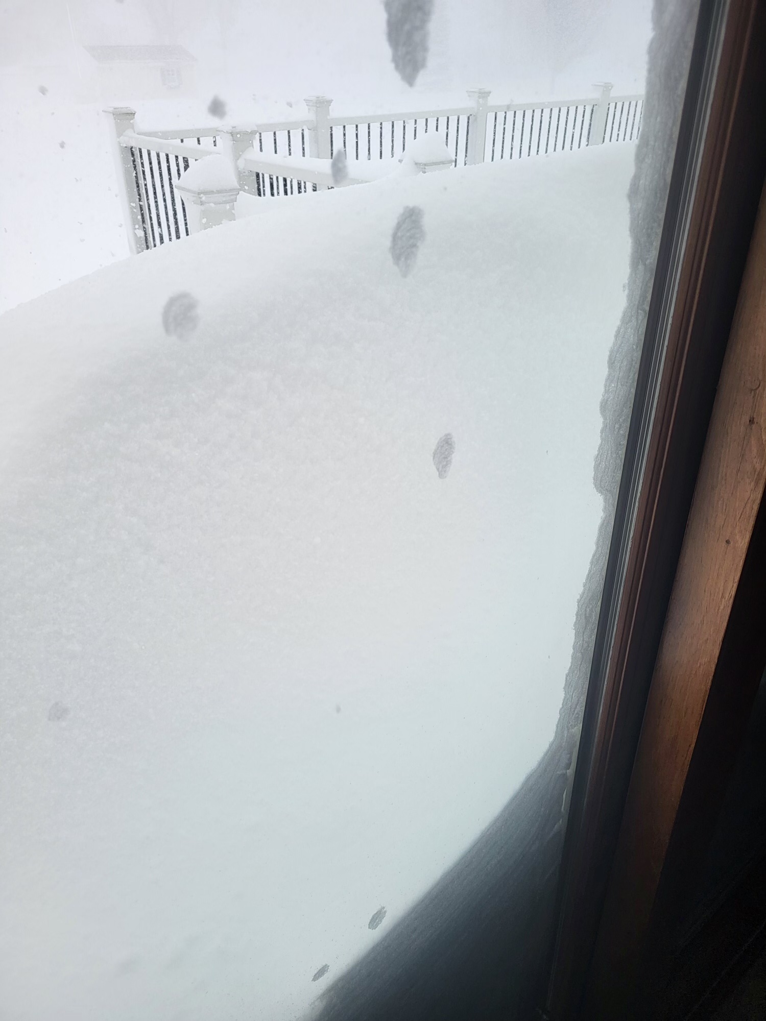
Media Delaware County low this morning was 4f lowest dewpoint I saw here was -10. It is currently just 6 degrees still windy gusting to 27 so windchill safely below zero still. The reports from family members out of Niagra falls in Buffalo just mind boggling. well over 3 feet of snow there as of this morning where they live winds past 24 hours 30-70 mph temps below zero with windchills well below zero. Right now, it is currently much warmer at 5f still wind-chill at -17. They are expecting another 25" today into tomorrow. Snow drifts where they are over 10 feet.
-
Media Delaware County 12f dewpoint -1 winds gusting to 40 mph.
-
0.07" in Media doubling the season totals here 16 degrees dew point 3 all snow either blew away or evaporated to to saw dust and blew away in the 30-40 mph winds.
-
Media 24 Sunny dewpoint 18 I did see a dead tree fall through wires causing a big blue power flash then fall onto a driving car below shattering the windshield on Baltimore Pike and Ridley Creek Road.
-
Media Delaware County light rain fog 43/41 pressure 29.01 falling. Winds SW 15-30 power went out here off and on 5 times in the last 10 minutes.
-
December 22-23, 2022: Warm Rain to Arctic Chill
Kevin Reilly replied to WxUSAF's topic in Mid Atlantic
I suppose most of the wind action must be above ground level elevated. -
December 22-23, 2022: Warm Rain to Arctic Chill
Kevin Reilly replied to WxUSAF's topic in Mid Atlantic
While it is true that is a squall line it probably has mangled snowflakes sleet or graupel causing more reflectivity. Probably some very gusty winds with that past 50 mph.