Kevin Reilly
-
Posts
3,401 -
Joined
-
Last visited
Content Type
Profiles
Blogs
Forums
American Weather
Media Demo
Store
Gallery
Everything posted by Kevin Reilly
-
 Well, Doug's ideas of what this winter are going to be like are spot on basically to date. Doug was up here in Philadelphia I liked him, and he is way better than anyone we have up here on NBC now. Now Doug's numbers in regard to snow may be off but at least his outlook up in my neck of the woods in southern PA indicates 4-10" of snow thus far we have a trace, so I guess there is hope not to shit the blinds still. So far up here in southern PA we are 10.3 degrees above normal in January and right to this date the Winter of 2022-2023 is ranked the 2nd warmest on record with an average temperature of 44.6 degrees right behind the warmest winter on record in 1932 of 46.4 degrees. I am guessing that if we did not get that cold snap around Christmas, we would be looking at the warmest winter on record but as Doug said February and March could be very warm, so we aren't done yet.
 -
E PA/NJ/DE Winter 2022-2023 OBS Thread
Kevin Reilly replied to Ralph Wiggum's topic in Philadelphia Region
Media Delaware County 36 dewpoint 26 Cloudy with sprinkles and light drizzle. I got giddy and saw the radar had a little stripe of white on it over my area. I go outside and it's just sprinkles and drizzle we can't even do this right!! -
E PA/NJ/DE Winter 2022-2023 OBS Thread
Kevin Reilly replied to Ralph Wiggum's topic in Philadelphia Region
Media Delaware County 42f Heavy Rain and Thunderstorms have ended skies have turned partly to mostly cloudy a few stars and some lightning in the sky to the east-northeast total rainfall today: exactly 1.00" -
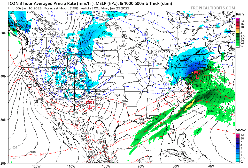
Noting the progressive nature of the flow with not much blocking and a somewhat flattened SER I would think this is further east like the last storm that developed to our east that looked like a tropical system but not that Far East
-
What year is that from? LOL Lock it in!! It's Happening!
-
We can get huge events early march March 1993 yes you can especially if deep arctic air rushes south to meet up with increasingly unstable humid warm Gulf of Mexico or Southwest Atlantic BOOM GOES THE DYNAMITE!!
-
E PA/NJ/DE Winter 2022-2023 OBS Thread
Kevin Reilly replied to Ralph Wiggum's topic in Philadelphia Region
12z Gfs just a dumpster fire
-
That’s the typical way we get snow in best climo heading late January to February.
-
E PA/NJ/DE Winter 2022-2023 OBS Thread
Kevin Reilly replied to Ralph Wiggum's topic in Philadelphia Region
getting closer
-
pretty good STJ input on that map!
-
Looks like a prime set up for a zonal overrunning events just so long as the cold air can set up and press down from the north I think we would be in business from January 27th to about February 8th or so.
-
E PA/NJ/DE Winter 2022-2023 OBS Thread
Kevin Reilly replied to Ralph Wiggum's topic in Philadelphia Region
Right on with my thinking. -
February 2003 Presidents Day
-
That my friend is happening looks right to me. Hmm That would yield a pretty significant severe weather event Tennessee Valley to Mid-Atlantic looks similar to February 2017 set up.
-
E PA/NJ/DE Winter 2022-2023 OBS Thread
Kevin Reilly replied to Ralph Wiggum's topic in Philadelphia Region
I love this can't stop watching. Guess this is where we need to go; at least for this year anways. Downtown Truckee | Tahoetopia -
E PA/NJ/DE Winter 2022-2023 OBS Thread
Kevin Reilly replied to Ralph Wiggum's topic in Philadelphia Region
I totally agree with this and the sea surface temperatures in the Pacific entire basin, Atlantic, and Gulf of Mexico say Ridge ON!!! Our weather pattern in the United States is tied to the Above normal sea surface temperatures near Japan north central Pacific... and Europe's lack of snow is tied to the above normal sea surface temperatures up and down the East coast of the United States right on out into the Atlantic. I have noticed anyone east, east-northeast, or northeast of these warm bodies of water have experienced above normal temperatures and below normal snowfall. It makes sense to me for sure. -
Hmm that supports my theory of warmer waters offshore affecting downstream not Japan. However, with that said they are experiencing 2009-2010 types of winter season that we did LOL.
-
Warm atlantic is always a poor excuse of non snow...if the track is good and we have strong hp...it will snow Not the case for those upstream from the Atlantic in Europe. I was watching from the mountains of Switzerland there was like zero snow the ski lifts were closed and they were getting ready to cut grass.
-
I checked Japan temps are at or below normal. Also, why would Japan be torching from warm waters to the east of Japan that torching effect would be all points east downstream. I will say that the warm SSTs off of Japan is most likely fueling the crazy weather pattern crashing into California and then the pattern redeveloping further east to cause tornadoes in the Southeastern States and the lack of snow in the Middle Atlantic States. We really need to stop thinking locally and start looking globally as to what is going on with sea surface temperatures. Any localities that are east or northeast of a warm body of water such as the Pacific or the Atlantic is experiencing above normal temperatures and below normal snowfall. In closing the state of the SST's are in large part in control of where the moisture and warm air transport is taking place around the northern hemisphere, this is locking the cold air well north over north America. In addition, the strong onshore flow off the Pacific is eroding the cold air in western Canada basically putting up a wall to not allow any southward progression of cold air hence no Alberta Clippers and so forth. Looking at posts above seems it is a problem all along the northern hemisphere with the warm SST's geeze worse than I thought. The only way then the pattern changes is by cooling the SST's down.
-
E PA/NJ/DE Winter 2022-2023 OBS Thread
Kevin Reilly replied to Ralph Wiggum's topic in Philadelphia Region
Media 28 Cloudy windy winds gusting to 40 mph? Getting 40 mph winds today was that forecasted? Also that storm offshore didn’t miss by much. -
+3??? at this rate we will be +5-6 if you factor the nighttime lows and daytime highs.
-
Could be an elongated trough but I am sure there would still be ways for storms to cut especially early on in the period.
-
No because the warm ocean wind flow from West to East across the Pacific has shut the door for Alberta Clippers. Albert Clippers ride along a temperature gradient there are none because the air is flowing right in off the Pacific throwing up the wall not allowing for the clippers.
-
Don't forget about the warm Pacific and Gulf of Mexico Waters Too all of this warmth is still trapped there from last summer and it is overwhelming the entire winter pattern. There is a lag land gets colder than water and water takes longer to cool off but as you said sometimes we need this warmth to set up a dynamic gradient but no way are we getting that without an arctic push.
-
E PA/NJ/DE Winter 2022-2023 OBS Thread
Kevin Reilly replied to Ralph Wiggum's topic in Philadelphia Region
dynamics breeds more dynamics.... I cannot disagree that we may see wild stuff between now and March. Something is going to give as the sun angle increases and causes more in the way of temperature gradients soon.