GaWx
-
Posts
19,030 -
Joined
Content Type
Profiles
Blogs
Forums
American Weather
Media Demo
Store
Gallery
Everything posted by GaWx
-
E PA/NJ/DE Summer 2026 Obs/Discussion
GaWx replied to PhiEaglesfan712's topic in Philadelphia Region
As of 10AM, Philly is 4F warmer than 24 hours ago (94 vs 90)! -
2026-2027 Super El Nino
GaWx replied to Stormchaserchuck1's topic in Weather Forecasting and Discussion
As of July 2nd per the DMI data, the mean Arctic temperature based on 80N+ has still not quite reached freezing although it was only barely below it yesterday. Going back to 1958, the latest day it first hit freezing before 2026 was way back on June 20th (2013)! Daily Mean Arctic temp. in degrees Kelvin: freezing is at 273.15 (July 2nd was 0.1C below freezing): 0260618 169 272.561676 20260619 170 272.634399 20260620 171 272.647522 20260621 172 272.469360 20260622 173 272.153870 20260623 174 271.679565 20260624 175 271.918213 20260625 176 272.421326 20260626 177 272.655334 20260627 178 272.803802 20260628 179 272.680786 20260629 180 272.732056 20260630 181 272.903717 20260701 182 272.963715 20260702 183 273.045624 https://download.dmi.dk/pub/plus80N_temperatureindex/meanT2026_running.txt -
Per this, the lowest at NYC as of 8AM today was 84: https://forecast.weather.gov/data/obhistory/KNYC.html
-
At C Park, the lowest so far today is 84. IF that were to hold up through 11:59PM, it would tie the all time highest low there on record!
-
Indeed! I’m not at all trying to minimize the heatwave in the NYC area. There has been some talk about Central Park running a couple of degrees cooler for highs than in the past due to increased foliage (showing the cooling power of foliage). Even so, 100F with increased foliage is obviously still very intense. Also, C Park had a low of only a ridiculous 82 yesterday! At C Park, the lowest so far today is 84. IF that were to hold up through 11:59PM, it would tie the all time highest low there, which goes way back to 1869!
-
Whereas La Guardia did hit 104 and Newark hit 105, the official Central Park high actually was “only” 100.
-
Once again the GFS (6Z) is way too hot in the extended. Even if H5 reaches the near record high upper 590s as it has, highs on July 14-15th will not reach anywhere near as hot as this shows even with the drought:6Z GFS July 14th highs: for example 112 at SAV is loltastic as that’s compared to the 105 all-time hottest on record there back 155 years! 6Z GFS July 15th highs: also not going to happen
-
2026-2027 Super El Nino
GaWx replied to Stormchaserchuck1's topic in Weather Forecasting and Discussion
This jibes with my response 3 posts above yours to Jeff B.’s implied false connection of the current developing super-Nino to increased very intense heat in the E US based on his Tweet. Only the summer of 1991 was hot overall in the E US as I said, which is essentially agreed with by your lists. I’m referring to Poughkeepsie’s 102 on 7/19/1991. None of the other developing super-Ninos prior to 2026-7 are on any of your 4 lists. -
2026-2027 Super El Nino
GaWx replied to Stormchaserchuck1's topic in Weather Forecasting and Discussion
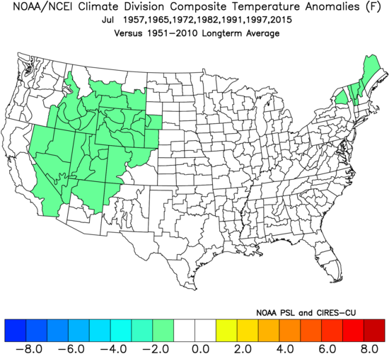
I don’t agree at all with Jeff B. implying a connection of super-Nino and the current E US heatwave. The mean temp in July (and also in summer as a whole) comes out close to normal rather than hot in the E US when averaging RONI based super strong El Niños. Hardly any were hot. 1957, 65, 72, and 97 were slightly cool. 1982 and 2015 were NN. Only 1991 was hot. That’s just 1 of the 7! That’s enough for me to say that the upcoming super-El Nino in combo with GW is not the direct cause for the current E US heatwave as Jeff said. GW, by itself, obviously favors hotter heatwaves than when the Earth was cooler. But the supposed super-El Nino piece of this, itself, correlating to E US summer heat does not compute to me at all. I also don’t at all agree with Jeff calling this one of the most expansive U.S. heatwaves. That’s simply not true. Intense in the VA to Boston corridor? Yes. But not one of the most expansive U.S. heatwaves. -
Thank you, but I don’t think I’m going to do July. I’m currently too busy to take enough time to analyze the data (forecast and historic) well.
-
Thanks, Don. I’ll reiterate that I was referring to only E US rather than all of the U.S. mean temps (especially in July) and that I didn’t even consider 2023 because it was only borderline moderate/strong on a RONI basis with a peak of only +1.49. So, 2015, with its heatwave in the Pacific NW (nowhere close to the E US) and 2023 not being nearly strong enough to count as super-Nino per the now official (per NOAA) RONI basis don’t even count for me against super El Niño E US heat. And even if 2023 were counted, its heat was most concentrated in the SW/SC rather than E US.
-
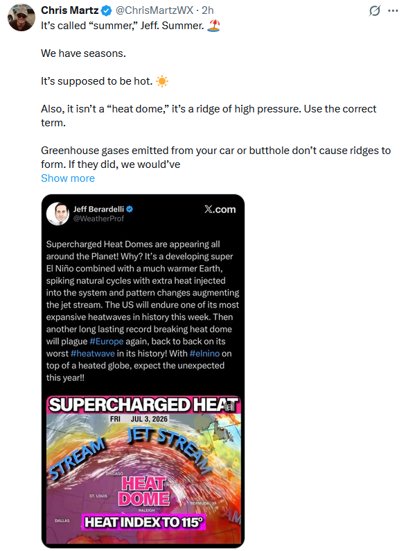
I’ll reiterate that I thought Chris Martz looked really bad due to saying “it’s called summer” and for saying “heat dome” wasn’t the correct term. However, I also said Jeff B. was wrong for calling the current/upcoming US heatwave one of the most expansive in history. Here again is Chris’ post responding to Jeff: But I forgot to earlier mention this: The mean temp in July (and also in summer as a whole) comes out close to normal rather than hot in the E US when averaging RONI based super strong El Niños. See image below. Hardly any were hot. 1957, 65, 72, and 97 were slightly cool. 1982 and 2015 were NN. Only 1991 was hot. That’s just 1 of the 7! That’s enough for me to say that the upcoming super-El Nino in combo with GW is not the direct cause for the current E US heatwave as Jeff said. GW, by itself, obviously favors hotter heatwaves than when the Earth was cooler. But the supposed super-El Nino piece of this, itself, correlating to E US heat does not compute to me at all. Thus whereas I thought Chris’ post was terrible, I also think Jeff’s was pretty bad, itself. @donsutherland1
-
As bad as it will be in much of the SE, consider that the NYC forecasted low for July 4th is a very oppressive 81 F!
-
Thanks. Looking forward to your update. Per the following source (AMSR2), the current Arctic ice area is now getting pretty low with it a bit lower than 2020 and 2016, ~0.5 million sq km lower than 2024, and ~0.4 million sq km lower than the 2013-24 mean. Do you know anything about the reliability of this source?
-
2026-2027 Super El Nino
GaWx replied to Stormchaserchuck1's topic in Weather Forecasting and Discussion
The CFS AAM forecast at the site I follow just updated for the first time in 6 days: Prior run there is 0Z of 6/25: strongest multi week mean I’ve ever seen/saved with it way up at a mean of +2.8 to +3.3 July 8th to end of run, which is July 29th: Brand new run (0Z of 7/1): still a very strong +AAM but not surprisingly no longer to the near record breaking levels of the 0Z 6/25 run as mean is ~+2.5 on July 8th instead of +2.8, mean then has a near term peak of ~+2.65 on July 12th-13th, and then it’s mainly low to mid +2s July 14-29th instead of +2.8 to +3.3: -
2026-2027 Super El Nino
GaWx replied to Stormchaserchuck1's topic in Weather Forecasting and Discussion
Thanks, Chris. I believe that would make the most up to date relative ENSO anomalies ~0.6C cooler than 1981-2010 anomalies in June. Is that incorrect? -
Please post July ‘26 obs from your area as well as current wx events/obs in July for other areas. It’s going to be quite hot with some records possibly being threatened especially in NC during the first part of the month. @buckeyefan1please pin this. Thank you.
-
2026-2027 Super El Nino
GaWx replied to Stormchaserchuck1's topic in Weather Forecasting and Discussion
Relative ENSO region anomalies are currently ~0.5 C cooler than 1991-2020 anomalies and likely ~0.6 to 0.7C cooler than 1981-2010 anomalies. -
2026-2027 Super El Nino
GaWx replied to Stormchaserchuck1's topic in Weather Forecasting and Discussion
Note that this is based on very outdated 1981-2010 climo. If instead it were using relative climo, that skinny La Niña tongue wouldn’t be as skinny since it would be compared to much more up to date warmer climo taking into account avg. warming of global tropical waters from GW. For the same reason, the surrounding tropical waters’ anomalies there wouldn’t be as warm. -
My total rainfall in June was ~5.35”.
-
2026-2027 Super El Nino
GaWx replied to Stormchaserchuck1's topic in Weather Forecasting and Discussion
It’s official. The DMI daily mean Arctic temp N of 80N, with the help of a +AO, never made it up to freezing in June! The previous latest to first get to freezing was June 20th, set in 2013. The June 30th # was -0.25C. Let’s see whether it gets above 0C on July 1st: @Stormchaserchuck1 -
2026-2027 Super El Nino
GaWx replied to Stormchaserchuck1's topic in Weather Forecasting and Discussion
If we stick to just high end moderate/strong/super Nino fall/winter peak with +QBO Dec, Dec was warm in all 5: 1957, 1982, 87, 94, 2015. Therefore, I think warm Dec is notably climo favored as of now. 1997 is neutral QBO, not +QBO. So, it doesn’t need to be considered. -
2026-2027 Super El Nino
GaWx replied to Stormchaserchuck1's topic in Weather Forecasting and Discussion
+QBO Nino Decembers: 1982 (warm temps), 1987 (warm), 1994 (warm), 2006 (warm), 2015 (warm), and 2018 (normal). I count 1997’s 0.78 as neutral QBO 2004’s +2.45 and falling is pretty neutral So, I agree on 6 Nino Dec +QBOs since 1980. And all but one were warm. 2018 was NN. Favors warmth in Dec for sure! And 1997/2004 (neutral QBO) weren’t warm. Edit: Dec of 1957 also had +QBO and was warm! But Dec of 1963 (moderate Nino) and Dec of 1969 (weak Nino) were cold despite +QBO. **Edit 2: If we stick to just high end moderate/strong/super Nino fall/winter peak with +QBO Dec, Dec was warm in all 5: 1957, 1982, 87, 94, 2015. Therefore, I think warm Dec is notably climo favored as of now. @PhiEaglesfan712 -
This is likely at least partially tied to the hot biased GFS not being as hot as it was (never was believable in the first place due to bias). But still the Carolinas and Virginia are facing a dangerous heatwave and potential records.
-
2026-2027 Super El Nino
GaWx replied to Stormchaserchuck1's topic in Weather Forecasting and Discussion
Thanks, Adam. Please explain to me how Marc is calling me a liar. I‘m not saying I don’t agree or disagree. I just want to know what you’re referring to. TIA.