

Windspeed
-
Posts
4,734 -
Joined
-
Last visited
Content Type
Profiles
Blogs
Forums
American Weather
Media Demo
Store
Gallery
Everything posted by Windspeed
-
TAFB/NHC has issued a code yellow for a weak disturbance near the North Carolina coastline that is forecast to move ENE in the coming days with 20/30 probs. It does have weak mid-level vorticity and could take on more tropical characteristics in the coming days as the system moves out into the open Atlantic. ZCZC MIATWOAT ALL TTAA00 KNHC DDHHMM Tropical Weather Outlook NWS National Hurricane Center Miami FL 200 PM EDT Thu Aug 13 2020 For the North Atlantic...Caribbean Sea and the Gulf of Mexico: The National Hurricane Center is issuing advisories on recently upgraded Tropical Storm Josephine, located over the tropical Atlantic Ocean several hundred miles east of the Lesser Antilles. 1. A low pressure area over eastern North Carolina is expected to move east-northeastward across the north Atlantic well to the south of New England and the Canadian Maritime provinces for the next several days. This system could acquire some subtropical or tropical characteristics during the next two to three days while it moves over warm sea surface temperatures. * Formation chance through 48 hours...low...20 percent. * Formation chance through 5 days...low...30 percent. Forecaster Beven
-
Has anyone said it was? Seems like most, including myself in recent posts, have gone to great lengths to cite the differences. Yet, ACE is still more than double climatological average for this date. It's also just Aug. 12th and we've had two hurricane landfalls in 2020 in addition to an ongoing TCG during an unfavorable period. You keep harping a specific operational model, in this case the GFS in the long-range, over and over again. I am uncertain why you are trying to climb upon this hill which to die. It's premature to do so a month prior to climatological peak. Counter arguments already established in this thread that we are in a less active period. It is too early to be locking down on a 240+ long-range operational output to make heads or tales of what will or will not occur versus just utilizing climatological modeling tools that such scenarios are better intended and better suited, such as ensemble precipitation guidance, long-range pattern and oscillation modeling, which do suggest a ramp up of activity across the Atlantic Basin in a few weeks.
-
Strong mid-level flow that has been tilting and displacing Josephine's mid-level vort from the low-level is forecasted to weaken this evening. There is already evident banding within the eastern MCS cloud canopy that is extending slightly more east of the vortex. Therefore, this strong flow may be beginning to back down now. A period of light shear should ensue the next 24 hours, some of that perhaps favorable to allow for some intensification before southwesterly shear increases over the system. Whether that buys enough time for more significant strengthening remains to be seen. Josephine does have a shot a Cat 1 intensity if it can establish a well-developed core over night. But it may not hold on to hurricane strength very long. Still, a nice little MDR TC to track until its inevitable demise in a few days.
-
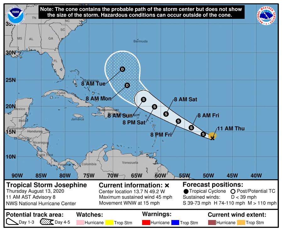
000 WTNT41 KNHC 131453 TCDAT1 Tropical Storm Josephine Discussion Number 8 NWS National Hurricane Center Miami FL AL112020 1100 AM AST Thu Aug 13 2020 A just-received ASCAT overpass showed an area of 35-40 kt winds about 70 n mi north of the center of Tropical Depression Eleven, and based on this the cyclone is being upgraded to Tropical Storm Josephine with an initial intensity of 40 kt. Satellite imagery shows that the convective pattern associated with Josephine has become a little better organized since the last advisory, with a ragged central convective feature and a weak band in the northern semicircle. The initial motion is now west-northwestward or 295/13 kt. Josephine should continue this motion for the next several days as it moves toward a weakness in the western portion of the Atlantic subtropical ridge. The global models forecast the western end of the ridge to weaken even more after 72-96 h, which should cause the cyclone, or what is left of it by that time, to turn northwestward. The track guidance is tightly clustered, and the new forecast track lies a little to the right of the previous track and a little to the left of the consensus models. Some additional strengthening appears likely during the next 24- 36 h as Josephine moves through an environment of light vertical wind shear. After that, the cyclone is expected to encounter moderate to strong southwesterly shear as it approaches an upper-level trough over the southwestern Atlantic, which should cause at least some weakening. The new intensity forecast is adjusted upward for the first 72 h based on the current intensity. After 72 h, it shows weakening similar to the previous forecast, but not as drastic as the global models that show the storm degenerating to a tropical wave before 120 h. Josephine is the earliest tenth tropical storm of record in the Atlantic, with the next earliest tenth storm being Tropical Storm Jose on August 22, 2005. FORECAST POSITIONS AND MAX WINDS INIT 13/1500Z 13.7N 49.2W 40 KT 45 MPH 12H 14/0000Z 14.5N 51.1W 45 KT 50 MPH 24H 14/1200Z 15.8N 53.6W 50 KT 60 MPH 36H 15/0000Z 17.1N 56.3W 50 KT 60 MPH 48H 15/1200Z 18.5N 58.9W 50 KT 60 MPH 60H 16/0000Z 19.9N 61.3W 45 KT 50 MPH 72H 16/1200Z 21.3N 63.6W 40 KT 45 MPH 96H 17/1200Z 24.0N 67.0W 30 KT 35 MPH 120H 18/1200Z 27.0N 68.0W 25 KT 30 MPH $$ Forecaster Beven
-
Last night's ECMWF ensembles were picking up on a AEW in the 7-10 day range and developing it near the Northern Leeward Islands. To be honest, the operationals have not been the greatest this year on TCGs. The GFS op even ghosted a CA monsoonal gyre last week and went so far to produce a fantasy GOM hurricane over many consecutive runs. Odd fantasy TCGs aren't unusual, but entire monsoonal gyres are. They also have not handled positioning of upper 200 hPa vorticity well for convection. So the GFS may've just had that too far displaced east over the Caribbean. WPAC TCG has been off as well in the operationals. At any rate, complaining aside, I'm not sure if it's a lack of global flight data or just bad luck. We're still in the long range for improving pattern and environmental factors in the 10+ day range, however. You want to focus more on ensembles in the long-range and ops for short-term TCG. But even in the short-term, the ops haven't been great.
-
Isaias was a fast mover and the depth of the 26° isotherm is very anomalous off the SE CONUS this year. It's been a very hot Summer with limited cloud cover and few stalled boundaries, especially over the past 30-40 days. Everything on the shelf is above 26°C now based on AOML; and since the shallow layer for SSTs is only 25-30 meters at depth, it essentially is anomalously warm right up to the shoreline. Though keep in mind, the isotherm map isn't on the same scale, as the shallow shelf is only 50 meters deep at interaction with the Gulf Stream, where, at that point, it drops well below 100 meters on a much higher gradient extending ESE. This may also be throwing off the TCHP map as depth of 26ºC isotherm is one of the data sets along with immediate surface layer temperature profiles. In past years, the shallow shelf was hardly represented by the 26º isotherm. Perhaps in recent years this was changed in the way data was displayed; however, if the entire shelf is above that isotherm, it should still be represented in the immediate surface layer at ~30 meter estimate. Though Isaias' low level circulation was amplified by a tropical low level southerly jet on its eastern semicircle due to trough interaction, it was really moving too fast and had too small an RMW to do anything but perhaps upwell and push ~28°C water from 50+ meters depth down the shelf near the Gulf Stream. The immediate landfall area did cool a few degrees, but that appears to be rebounding fast due to hot days + clear skies. Also recall that Isaias only managed to regain hurricane intensity very near the South Carolina shoreline. Additionally, it remained rather devoid of convection on its southern semicircle and struggled to mix down higher winds until interaction with the coast. Its windfield only expand near landfall with influence of the low level jet and baroclinic enhancement up the Mid-Atlantic coast. In comparison, Hanna was a slow mover with a much broader low level circulation as it traversed the Central GOM and had a large region of persistent intense multi-convective systems that did a number on the shallow layer heat content, not to mention some extended upwelling. But that's been several weeks ago and, unsurprisingly, the Central and WGOM immediate shallow layer is running ~29-31°C again.
-
In a meteorological sense, it's called oceanic lag time. The ocean heat content always lags behind atmospheric mean temperature gain. It also takes time, even in the most favorable large scale patterns, for hurricane season to reach fruition.
-
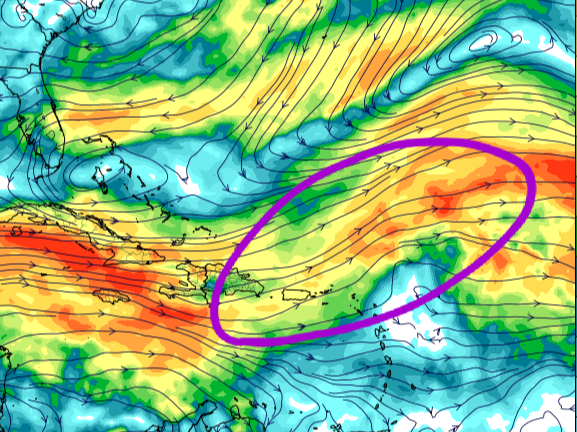
If I read you right, you're calling for 2 hurricanes and 1 major hurricane the remainder of the season? I mean that's fine but you realize it's August 12th? Climatological favorability across the basin doesn't normally kick in until around August 20th-26th even in active years. I think a lot of folks fail to realize how quickly an unfavorable synoptic and environmental pattern can transition to favorable. Shear issues appear to be short-term. The hostile westerly upper level flow across the Caribbean is due to the current convective outbreak in the Eastern Pacific. However, more favorable upper 200 hPa vorticity will shift to over the Atlantic Basin by August 20th. Westerly windshear will decrease as the EPAC swings into a more suppressed regime. Likewise the strong easterly 700 hPa windbursts that have driven SAL will back down as Azores SPHP shifts into a more SER/WAR extended pattern (as is typical does this time of year). As such, the MDR will moisten for the September run. Sub-800 hPa to sea level pressures have already been running lower than climatological mean. All these factors within consideration, I think some folks are going to be taken surprise during the peak regardless of the active to hyperactive forecasts.
-
I am not making any adjustments. Signals still scream a crazy active peak that is prolonged through October with -ENSO and +AMO signals. Now how NAO evolves could influence deep Caribbean tracks versus more interaction with the Eastern Seaboard. WAR/SER should be in place through October though. There will still be westerly shortwaves and intermittent weaknesses for recurves. But several TCs will time under waxing extensional Azores-Bermuda ridging versus waning as troughs lift over New Foundland and Greenland maritimes with robust SERs rebuilding in place; therefore, I do not think we're staring down another 2010/2011 type active season where everything is central Atlantic based. I should specify peak MDR/CV stretch of season, as this season up to this point is entirely dissimilar. Perhaps something akin to 2004 and 2008 with enough blocking in place to drive some W. Caribbean and GOM systems like Ike, Gustav, Ivan, Felix, Frances, etc. Again, I want to avoid 2005 in comparison because, if you recall, after July we really did not have many MDR/CV long-tracking hurricanes that reached the far WATL. Katrina developed out of TD10 remnants in the Bahamas. Rita was home grown as well. Wilma was pure WCARIB post frontal and tropical wave interaction. All those other numbers were among a swarm of TCs that developed out in the middle of the central Atlantic. Again, with the pattern evolving, I will be surprised if we don't have at least a few hurricanes that eat up some longitude and become Antilles, Central America or SE Conus threats. Not saying it will be 2017 again, but can you imagine a 2017-like year in the MDR but with significantly greater longitudinal tracks?
-

2020 East & Central Pacific Hurricane Season
Windspeed replied to jgf's topic in Tropical Headquarters
-
July of 2005 was so anomalous, I'm not sure it's even reasonable to compare ACE numbers to it. When you have two long-tracking major hurricanes that reached Category 4 and 5 prior to peak weeks, it remains a freak outlier in terms of ACE compared to even other hyperactive years. 2017, 2010, 2008, 2004, 2003, 1999, 1998, 1995 and so forth are much more in line climatologically speaking. This year so far has been more about numbers of named storms, though I do expect ACE to be skyrocketing in September this year regardless of hyperactive or just normally active.
-
The would-be Josephine does have a good shot at hurricane intensity and could overperform during a 24 hour window. Easterlies back down and prior to TUTT development, upper divergent flow may create an environment for RI if only for a 12-hr period, but that could be enough. Still don't think I'd be bold enough to call for a Category 3 until we see a well-developed core. Stable 700 hPa Theta-E can break hearts. Regardless of intensity swings, Josephine will have a rough go beyond 72 hours when those westerlies start cranking. Here is Stewart's 5AM: The aforementioned unfavorable conditions of dry air entrainment and southeasterly shear are expected to give way to more conducive environmental conditions by 24 h when the cyclone will begin to move underneath the center of a synoptic-scale upper-level anticyclone. This will result in the shear decreasing to near zero, along with a pronounced improvement in the upper-level outflow pattern. The much lower shear conditions should also reduce the amount of dry air entrainment, while allowing for some moistening of the surrounding environment to occur. These more favorable conditions are expected to persist through at least the 60-h period, and thus slow but steady strengthening is forecast during that time. By 72 h and beyond, the global models and regional models show the system moving out from underneath the positive influence of the upper-level anticyclone, encountering moderate southerly to southwesterly vertical wind shear, which is expected to induce gradual weakening. It should be noted that during the 48-60 h period when the shear will be the lowest and sea-surface temperatures will be near 28.5C, there is a narrow window of opportunity where the intensity could peak higher than what is currently indicated. The new NHC intensity forecast is very similar to the previous advisory, and is slightly higher than the consensus intensity consensus models IVCN and HCCA due to anticipation of the very favorable low-shear conditions. I do think Josephine becomes a hurricane for a day, but it won't last long with that 30+ kts of shear blocking its path:
-
You mean the season so far or just the hype? The season so far is not really indicative of the potential that exists in a few weeks. If we're hearing crickets by the second week of September, then I'd start considering a bust. Still, we have had two hurricanes already, albeit not a lot of ACE withstanding. Yet, more than double climatological mean for this date. At any rate, a busy four-to-five week stretch can produce a lot of hurricanes. Too many examples of that to even mention. You can look up most active years and see when they really took off. I would also add that as far as seasonal forecasts, a very real bust is certainly possible, though I think it is rather unlikely that we miss out on an active season. A bust for hyperactive forecasts is obviously still very much in play simply due to their rarity. That we had so many forecasts favoring hyperactivity is due to many favorable factors coming into play for the height of the season, which, we are not there yet. We're still waiting for all of those ingredients to produce. Also, bust or no bust, yes, we could have a nightmare hurricane landfall and if we do not reach sufficient ACE and numbers, it would still be a bust. I know most of you, if not all, realize this. But therein lies the rub, even if we do have a bust, those factors likely do produce some majors that track into the Caribbean. We don't have the same setup as 2010 and 2011. We're going to see some strong long-tracking hurricane impacts in 2020. Edit: Err.. 2011, not 2013. lol... That an entirely different scenario. Just, no. Also, I keep adding on and on to this post, sorry, however, I also want to point out that[mention=1541]Scorpion[/mention] never said anything about a bust. They were referring to hyperactive seasons with no major hurricane impacts. I just brought up the bust discussion because it seems to be floating around already in this thread and I was already rambling besides.
-
Felt it as well. Felt very subtle. Could hear the bedroom doors rattling, some creeking of the house and I could make out / hear a low amplitude rumble. Honestly thought it might have been a low flying jet at first. But immediately considered it might be a nearby quake because I am a geoscience dork. Then I got the quake notification from the USGS. No doubt being in the Valley and located on sedimentary basement sequences carried those shallow waves through the region. In comparison, I recall feeling the motion of the 5.8 quake in the Piedmont of Eastern Virginia more than this latest 5+ tremor. Though the epicenter was further away, the strength of August 2011 quake must have carried through the region more. Actually witnessed a floor lamp swaying during that 2011 one.
- 186 replies
-
- 3
-

-
- tennessee river valley
- wind
- (and 4 more)
-
If Josephine forms in the next few days out of 95L, it's probably not going to survive much beyond the Lesser Antilles, regardless of short-term intensity changes. The outbreak of tropical activity and convection in the EPAC is going to really ramp up westerly upper level flow across the Caribbean and WATL as TUTTs form and retrograde. In fact, whatever might develop in the Atlantic over the next 10-12 days may struggle with shear. However, that being said, the MJO phases favorably over the basin the last week of August while coinciding with a sharp decrease in shear as the EPAC goes quiet. Perhaps a little sooner. But for now we seem to have some ammo against long-trackers over the next week. We still have to watch though in case some poor struggling sheared disturbance happens to find itself NE of the Antilles and an upper ridge builds.
-
-
-
Good thread on the lack of support. Right now it is in a moist bubble, but in a few days NW flow into a circulation could be quite a hindrance to continued intensification:
-
-
Yes, I meant 95L but typed 94L. [emoji849]
-
95L has been designated by TAFB. NHC has coded yellow and a 20% chance of development in 5 days. However, the environment is not necessarily unfavorable for development in the waves current location. It looks healthy, has a defined circulation, good convection and mid level vorticity, albeit still weak. I'd give this a better chance at TCG the next few days. It does not have the greatest model support atm, but the ECMWF ensembles do have it. Edit: 95L, not 94L.
-
You simply want to avoid sinking from height. This is counterintuitive to steeper lapse rates and CAPE needed to sustain convection for significant period of time to support TCG. However, it does not mean you cannot have a TC do well for itself if already developed. We have seen strong canes in an MJO suppressed phase, but typical when the TC had already gone through genesis. Strong upper vorticity helps TCG. But it is kind if meh as being proven to maintain intense hurricanes, which will have already superceded an atmospheric environment and SSTs, upper outflow pattern, wind shear and poleward velocities become of greater importance than MJO phase.
-
Great discussion going on here... My take away, probably going to be plenty of lift across the basin regardless of the +IOD to make things go crazy from Aug. 20th into October.
-
Potential and modeling of all these variables are stacking up for it to really ramp up. I suppose you never know what will occur IRL until it happens, but it certainly looks concerning. Probably one of the biggest flashing exclamation points is the southerly prognosis of deep Caribbean runners with low shear. That has been modeled with consistency for several months. The large scale pattern supports that. Some of those could be big impacts for central America. But certainly having southerly tracking storms at that trajectory puts Florida and the GOM into play with any digging trough through the plains. Going to get interesting fo'sho.

