

Windspeed
-
Posts
4,734 -
Joined
-
Last visited
Content Type
Profiles
Blogs
Forums
American Weather
Media Demo
Store
Gallery
Everything posted by Windspeed
-
July of 2005 was so anomalous, I'm not sure it's even reasonable to compare ACE numbers to it. When you have two long-tracking major hurricanes that reached Category 4 and 5 prior to peak weeks, it remains a freak outlier in terms of ACE compared to even other hyperactive years. 2017, 2010, 2008, 2004, 2003, 1999, 1998, 1995 and so forth are much more in line climatologically speaking. This year so far has been more about numbers of named storms, though I do expect ACE to be skyrocketing in September this year regardless of hyperactive or just normally active.
-
The would-be Josephine does have a good shot at hurricane intensity and could overperform during a 24 hour window. Easterlies back down and prior to TUTT development, upper divergent flow may create an environment for RI if only for a 12-hr period, but that could be enough. Still don't think I'd be bold enough to call for a Category 3 until we see a well-developed core. Stable 700 hPa Theta-E can break hearts. Regardless of intensity swings, Josephine will have a rough go beyond 72 hours when those westerlies start cranking. Here is Stewart's 5AM: The aforementioned unfavorable conditions of dry air entrainment and southeasterly shear are expected to give way to more conducive environmental conditions by 24 h when the cyclone will begin to move underneath the center of a synoptic-scale upper-level anticyclone. This will result in the shear decreasing to near zero, along with a pronounced improvement in the upper-level outflow pattern. The much lower shear conditions should also reduce the amount of dry air entrainment, while allowing for some moistening of the surrounding environment to occur. These more favorable conditions are expected to persist through at least the 60-h period, and thus slow but steady strengthening is forecast during that time. By 72 h and beyond, the global models and regional models show the system moving out from underneath the positive influence of the upper-level anticyclone, encountering moderate southerly to southwesterly vertical wind shear, which is expected to induce gradual weakening. It should be noted that during the 48-60 h period when the shear will be the lowest and sea-surface temperatures will be near 28.5C, there is a narrow window of opportunity where the intensity could peak higher than what is currently indicated. The new NHC intensity forecast is very similar to the previous advisory, and is slightly higher than the consensus intensity consensus models IVCN and HCCA due to anticipation of the very favorable low-shear conditions. I do think Josephine becomes a hurricane for a day, but it won't last long with that 30+ kts of shear blocking its path:
-
You mean the season so far or just the hype? The season so far is not really indicative of the potential that exists in a few weeks. If we're hearing crickets by the second week of September, then I'd start considering a bust. Still, we have had two hurricanes already, albeit not a lot of ACE withstanding. Yet, more than double climatological mean for this date. At any rate, a busy four-to-five week stretch can produce a lot of hurricanes. Too many examples of that to even mention. You can look up most active years and see when they really took off. I would also add that as far as seasonal forecasts, a very real bust is certainly possible, though I think it is rather unlikely that we miss out on an active season. A bust for hyperactive forecasts is obviously still very much in play simply due to their rarity. That we had so many forecasts favoring hyperactivity is due to many favorable factors coming into play for the height of the season, which, we are not there yet. We're still waiting for all of those ingredients to produce. Also, bust or no bust, yes, we could have a nightmare hurricane landfall and if we do not reach sufficient ACE and numbers, it would still be a bust. I know most of you, if not all, realize this. But therein lies the rub, even if we do have a bust, those factors likely do produce some majors that track into the Caribbean. We don't have the same setup as 2010 and 2011. We're going to see some strong long-tracking hurricane impacts in 2020. Edit: Err.. 2011, not 2013. lol... That an entirely different scenario. Just, no. Also, I keep adding on and on to this post, sorry, however, I also want to point out that[mention=1541]Scorpion[/mention] never said anything about a bust. They were referring to hyperactive seasons with no major hurricane impacts. I just brought up the bust discussion because it seems to be floating around already in this thread and I was already rambling besides.
-
If Josephine forms in the next few days out of 95L, it's probably not going to survive much beyond the Lesser Antilles, regardless of short-term intensity changes. The outbreak of tropical activity and convection in the EPAC is going to really ramp up westerly upper level flow across the Caribbean and WATL as TUTTs form and retrograde. In fact, whatever might develop in the Atlantic over the next 10-12 days may struggle with shear. However, that being said, the MJO phases favorably over the basin the last week of August while coinciding with a sharp decrease in shear as the EPAC goes quiet. Perhaps a little sooner. But for now we seem to have some ammo against long-trackers over the next week. We still have to watch though in case some poor struggling sheared disturbance happens to find itself NE of the Antilles and an upper ridge builds.
-
-
-
Good thread on the lack of support. Right now it is in a moist bubble, but in a few days NW flow into a circulation could be quite a hindrance to continued intensification:
-
-
Yes, I meant 95L but typed 94L. [emoji849]
-
95L has been designated by TAFB. NHC has coded yellow and a 20% chance of development in 5 days. However, the environment is not necessarily unfavorable for development in the waves current location. It looks healthy, has a defined circulation, good convection and mid level vorticity, albeit still weak. I'd give this a better chance at TCG the next few days. It does not have the greatest model support atm, but the ECMWF ensembles do have it. Edit: 95L, not 94L.
-
You simply want to avoid sinking from height. This is counterintuitive to steeper lapse rates and CAPE needed to sustain convection for significant period of time to support TCG. However, it does not mean you cannot have a TC do well for itself if already developed. We have seen strong canes in an MJO suppressed phase, but typical when the TC had already gone through genesis. Strong upper vorticity helps TCG. But it is kind if meh as being proven to maintain intense hurricanes, which will have already superceded an atmospheric environment and SSTs, upper outflow pattern, wind shear and poleward velocities become of greater importance than MJO phase.
-
Great discussion going on here... My take away, probably going to be plenty of lift across the basin regardless of the +IOD to make things go crazy from Aug. 20th into October.
-
Potential and modeling of all these variables are stacking up for it to really ramp up. I suppose you never know what will occur IRL until it happens, but it certainly looks concerning. Probably one of the biggest flashing exclamation points is the southerly prognosis of deep Caribbean runners with low shear. That has been modeled with consistency for several months. The large scale pattern supports that. Some of those could be big impacts for central America. But certainly having southerly tracking storms at that trajectory puts Florida and the GOM into play with any digging trough through the plains. Going to get interesting fo'sho.
-
 Researchers find link between Atlantic hurricanes and weather system in East Asia https://phys.org/news/2020-08-link-atlantic-hurricanes-weather-east.html
 -
Somewhat normal. June into early August tends to have SAL outbreaks due to strong sub 700 hPa level easterly wind bursts off of NW African continent. Azores SPHP and intensity of 500 dm heights in the Eastern Atlantic are generally at their strongest. Interestingly there is also correlation to SAL, the West African Monsoonal flow (WAM) and increased numbers of AEWs. In some respects, SAL is just a byproduct between WAM and EATL ridging; and although SAL helps to keep many AEWs in check through the MDR, it doesn't always persist into September and October. Generally by mid-to-late July, the orientation of Azores influenced ridging has shifted into stronger western Atlantic ridging (WAR) pattern, especially with a negative ENSO, and a positive AMO and NAO. Sometimes earlier in late July, sometimes later into late August. An overall suppressed regime of the Atlantic sub tropics to ITCZ should be shifting in the next week or two to one much more favorable for TCGs. I should add that despite the strong SAL outbursts back in July, we still had AEWs go on to develop. Even if Gonzalo eventually succumbed to a hostile environment, Isaias did not. All this pretty much leads to the idea that when atmospheric favoribility does increase through the MDR, it's likely to get very active.
-
The 0z ECMWF ensembles are very temporary with any development out of the new lemon. All tracks of the weak area of low pressure get squashed. However, deeper into the forecast period they do want to develop an AEW that has yet to exit the African continent. This would be in the 7-10 day range coinciding with an increasing favoribility in the MDR and leading into better upper 200 hPa vorticity across the western MDR.
-
We have a new lemon in the MDR, west-southwest of the Verdes. Not the best environment that becomes less conducive in a few days. But who knows... ZCZC MIATWOAT ALL TTAA00 KNHC DDHHMM Tropical Weather Outlook NWS National Hurricane Center Miami FL 800 AM EDT Fri Aug 7 2020 For the North Atlantic...Caribbean Sea and the Gulf of Mexico: 1. A tropical wave is located several hundred miles west-southwest of the Cabo Verde Islands. Slow development of this system is possible during the next couple of days as it moves slowly westward. After that time, environmental conditions are expected to become less conducive for development. * Formation chance through 48 hours...low...10 percent. * Formation chance through 5 days...low...10 percent. Forecaster Beven
-
Uh oh...
-
The fantasy Yucatan system is the same disturbance the GFS has consistently resolved in the 240+ hr range. Again, too far out to take seriously, but at least notable in the OPs consistency to keep an eye on that general monsoonal trough + wave interaction, and favorable upper 200 hPa vorticity for potentially something of interest around the mid-to-late month in the WATL. Interestingly, the fantasy EPAC system could interfere as a powerful hurricane could create less favorable downstream upper flow over Mexico into GOM. At any rate, far enough out that literally nothing might develop IRL in both basins.
-
So far 2020 has been gangbusters. We're low on ACE considering number of named storms due to no majors or long-tracking storms with persistent hurricane intensity, but that is likely to change in a couple of weeks regardless of short-term development. We are still way ahead on ACE as well versus climatological mean.
-
Well if we're going to play the ~300 hr fantasy land game, why hello there upper divergent atmospheric crack on steroids...
-
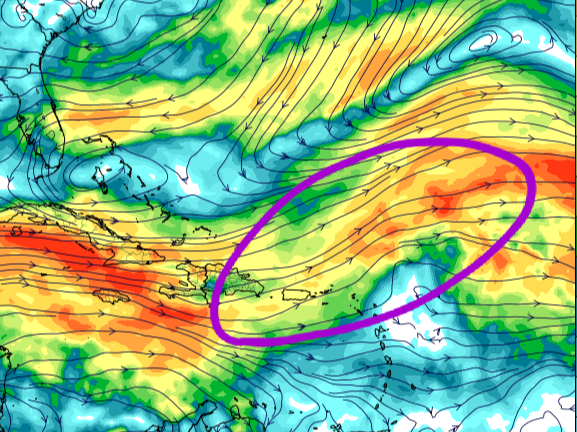
This is somewhat ominous. Wind shear has been anomalously low. Sure, there has still been shear, hence Isaias' struggles and being kept in check through the Bahamas and east of Florida. Still, wasn't enough to kill it as we have seen in past seasons with early TCs. Climatological shear tends to reach its lowest point throughout the MDR and WATL by September. How anomalous lower shear heading into this period affects TCG and long-trackers remains to be seen, but it's enough to raise an eyebrow.


