-
Posts
4,734 -
Joined
-
Last visited
Content Type
Profiles
Blogs
Forums
American Weather
Media Demo
Store
Gallery
Everything posted by Windspeed
-
2020 East & Central Pacific Hurricane Season
Windspeed replied to jgf's topic in Tropical Headquarters
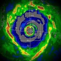
Genevieve is now a major hurricane. Still forecast to peak as a Category 4 and still intensifying; perhaps not as rapidly as some of the guidance suggested, though still plenty swift to be in upper RI range. The system was classified just 44 hours ago. The chaotic nature of an eyewall core vortex evolving. It still has plenty of time to make a run at Category 5 as favorable conditions will persist 12-24 hrs and MPI could be reached by this evening. By Wednesday evening conditions will not be as supportive. Regardless of peak intensity, looking for Genevieve to ramp up deeper internal convection today. -

2020 East & Central Pacific Hurricane Season
Windspeed replied to jgf's topic in Tropical Headquarters
Genevieve is trying to clearing out a persistent eye. Really well-developed hurricane now with impressive structure. -
The GFS-Para is the experimental GFSv16 versus the current operational GFS model (GFSv15) that has been in operation since 2019. GFSv16 would potentially be the new operational GFS next year barring any upgrade setbacks. At any rate, this morning's run had a very interesting throwback track to Charley. Again, this is an experimental product and even if operational, would be out in the medium range if 97L were to develop. Still interesting nonetheless...
-
2PM EDT Outlook with respect to 97L: A tropical wave approaching the Windward Islands is producing a large area of disorganized shower and thunderstorm activity. This disturbance is moving westward at about 20 mph, and is expected to continue to move quickly westward over the eastern and central Caribbean Sea during the next couple of days, which is likely to limit significant development. After that time, however, the system is expected to move more slowly westward across the western Caribbean, where upper-level winds could become more conducive for the development of a tropical depression during the latter part of this week. Regardless of development, locally heavy rainfall and gusty winds are expected over portions of the Windward and southern Leeward Islands through Tuesday morning. * Formation chance through 48 hours...low...20 percent. * Formation chance through 5 days...medium...50 percent.
-
2PM EDT Outlook: ZCZC MIATWOAT ALL TTAA00 KNHC DDHHMM Tropical Weather Outlook NWS National Hurricane Center Miami FL 200 PM EDT Mon Aug 17 2020 For the North Atlantic...Caribbean Sea and the Gulf of Mexico: 1. A tropical wave approaching the Windward Islands is producing a large area of disorganized shower and thunderstorm activity. This disturbance is moving westward at about 20 mph, and is expected to continue to move quickly westward over the eastern and central Caribbean Sea during the next couple of days, which is likely to limit significant development. After that time, however, the system is expected to move more slowly westward across the western Caribbean, where upper-level winds could become more conducive for the development of a tropical depression during the latter part of this week. Regardless of development, locally heavy rainfall and gusty winds are expected over portions of the Windward and southern Leeward Islands through Tuesday morning. * Formation chance through 48 hours...low...20 percent. * Formation chance through 5 days...medium...50 percent. 2. A tropical wave over the eastern tropical Atlantic is forecast to interact with another disturbance located several hundred miles southwest of the Cabo Verde Islands within the next day or two. This interaction is expected to lead to the formation of a broad area of low pressure, and conditions are forecast to be conducive for the development of a tropical depression during the middle-to-latter part of this week while the system moves westward to west- northwestward at 15 to 20 mph across the central and western portions of the tropical Atlantic. * Formation chance through 48 hours...low...30 percent. * Formation chance through 5 days...high...70 percent. Forecaster Brown
-
You're going to come off as quite bipolar in your postings if you start hanging on each GFS operational run for long-range track and immediately making a declaration of death in your "outlook" of the upcoming period every time that track doesn't pan out. The very next run could have an entirely different TCG location and resulting stronger track intensity ~120 hrs out. Best to just realize we have potential development to follow. The ensembles are still more valuable in the long range as has already been stated multiple times, repeatedly. When we actually do have a TC to track, we then may start focusing more on operational track placement and pattern, though you still must be cautious beyond 144+ hrs for the downstream pattern, as that can easily flip. At any rate, your persistent declarations about the peak season being this or that based on single operational model outputs every six hours is not particularly contributive to the discussion. That's not to say we should not point out a pattern that swings more unfavorable. But that is entirely not what is being suggested by modeling here in the mid-to-long range.
-
Thought that was already deemed 98L. Sometimes they'll discuss them as ALxx. Former NHC Specialist Kimberlain referred to the disturbance as AL98 earlier. At any rate, unsurprisingly the GFS weaker in the mid-to-long range with the potential TC due to tracking through the Greater Antilles and timing/position being not as aligned with strong upper ridging. That upper ridging is a beast though and is probably more the takeaway; i.e., IF a TC gets positioned under that, things could escalate quickly.
-

2020 East & Central Pacific Hurricane Season
Windspeed replied to jgf's topic in Tropical Headquarters
425 WTPZ42 KNHC 171451 TCDEP2 Hurricane Genevieve Discussion Number 5 NWS National Hurricane Center Miami FL EP122020 1000 AM CDT Mon Aug 17 2020 Data from a recent SSMIS microwave overpass reveals that an eye is trying to form underneath the deep convection of Genevieve, but there is some dry air near the center that may be disrupting the formation of a solid eyewall. Despite that dry air, large bands continue to the southwest and northwest of the center, and the deep convection over the center is expanding in size. The latest Dvorak satellite intensity estimates from both TAFB and SAB support raising the initial intensity to 65 kt, making Genevieve the third hurricane of the 2020 Eastern Pacific hurricane season. Genevieve jogged a little northwest over the past few hours, but the longer term motion has been west-northwest at 16 kt. The main steering mechanism for the cyclone is a strong mid-level ridge which extends from the southwestern United States southeastward into Mexico. The model guidance varies slightly on the strength and orientation of this ridge over the next few days, which could play a role in how close Genevieve gets to the southern portion of the Baja California Peninsula. The GFS is the farthest east, but still keeps the center well offshore, while The UKMET is the westernmost solution. Overall, the guidance has changed little since early this morning, and the official forecast is very near the previous track, which lies near the TVCX/TVCE consensus. The small amount of dry air near the center should get worked out of the circulation shortly, and there is high confidence that the rapid intensification of Genevieve will continue for the next 24-36 h. The SHIPS Rapid Intensification Index (RII) shows a greater than 95 percent chance of a 30 kt increase in strength in the next 24 h, and nearly an 80 percent chance of a 45 kt increase in the next 36 h. The global, regional, and consensus intensity aids all agree that rapid intensification will occur in one form or another during this time frame as well. The official intensity forecast is a blend of the HFIP corrected consensus and the IVCN consensus, and is very close to the previous forecast. Large swells generated by Genevieve are expected to begin affecting portions of the coast of southern Mexico today and will spread northward along the coast of Mexico to the Baja California peninsula by Wednesday. FORECAST POSITIONS AND MAX WINDS INIT 17/1500Z 14.3N 103.0W 65 KT 75 MPH 12H 18/0000Z 15.4N 105.0W 85 KT 100 MPH 24H 18/1200Z 17.0N 107.3W 105 KT 120 MPH 36H 19/0000Z 18.4N 109.0W 120 KT 140 MPH 48H 19/1200Z 19.7N 110.2W 120 KT 140 MPH 60H 20/0000Z 21.0N 111.1W 110 KT 125 MPH 72H 20/1200Z 22.2N 112.4W 95 KT 110 MPH 96H 21/1200Z 24.3N 115.2W 65 KT 75 MPH 120H 22/1200Z 26.4N 118.7W 45 KT 50 MPH $$ Forecaster Latto -
NW periphery of 97L's wave axis is now moving through the Windward Islands of the Lesser Antilles. Nothing immediately eye-opening yet. Convective showers and storms embedded in strong easterly flow around the wave. If something within the axis begins to fold, it's likely to be a tick east and not coming into range of radar until later this evening.
-
Nice post by Todd Kimberlain. My takeaway here would be AL98 staying relatively weak regardless of TCG until it begins to approach the Lesser Antilles. Lower steering flow will begin to align more with upper steering flow, which would likely allow the system to stack better vertically. The GFS has been a little wonky with convective feedback over the EPAC in the long-range, given some of the oddball convective spin-ups after Genevieve considering the shift of upper 200 hPa vorticity eastward; yet it continues to show a mighty large upper ridge / anticyclone developing over the Caribbean and GOM late in the period, which could spell trouble if a hypothetical TC is moving through the region. There is also a strong STJ that splits flow and ejects eastward over the Southern CONUS. That would seemingly decrease upper level westerlies over the NW Caribbean and GOM downstream. Again, this all means squat if there is no TC there to take advantage. I am still apprehensive of the GFS right now. So take the strong fantasy Caribbean runner with a grain of salt until we actually have a TC to track.
-

2020 East & Central Pacific Hurricane Season
Windspeed replied to jgf's topic in Tropical Headquarters
Actually I take that back. There is never an easier Category 5 call with a TC at TS intensity even with SHIPS values this ridiculous. The evolution of the vortex will still have most sway on how rapid it can accelerate spin. This is most dependent on convective structure; therefore, if the cyclone is faster at forming a very organized eyewall band versus prolonged competing convective cells, it might reach Cat 5. The issue is Genevieve only having roughly 60 hrs before atmospheric conditions decrease its MPI. So even though intensity modeling is very rapid with intensification, Genevieve may still not have time to iron out the internal structure of its vortex to fulfill an MPI above Category 4 before shear increases. I.e., atmospheric conditons may be near perfect out ~60 hrs, but Genevieve's structural evolution might still not be fast enough. At any rate, Cat 5s are never easier to forecast unless you already have a well-developed hurricane, adequate time and rapid intensification is already underway. -

2020 East & Central Pacific Hurricane Season
Windspeed replied to jgf's topic in Tropical Headquarters
That output is just ridiculous. Don't ever recall seeing 100% values for such large gains in a 48 hr period. Shear does increase in the late forecast period ~72 hrs; however, MPI is so high this may be one of those easier calls for a Cat 5. Hopefully it stays away from the southern Baja. -
In the short-term, the wave just east of the Lesser Antilles does have weak vorticity and increasing convection, especially on its SW axis. Some of last night's EPS showed potential development of this disturbance, though today's 12z ECMWF operational keeps this open into central America. The 12z UKMET and GEM operationals are much more forgiving and do want to produce a TC as it traverses the deep Caribbean. No need to mention the 12z GFS since @Idub23 has that covered into September. [emoji6]
-
12z ECMWF now runs a TC, presumably the AEW that just exited Africa, just north of the Antilles through the Florida Straits and deep into the Gulf. Extends WAR and builds heights. Obviously this is way out in fantasy long range, but we now have a major operational model coming into line with its ensembles. Was only a matter of time. Now we'll just have to be patient and see how TCG occurs and where. Additionally how the upper pattern will unfold as any potential systems reach the WATL. We are too far out to know if any particular potential TC will aligned under a favorable or unfavorable setup. A lot of variables and a lot depends on downstream TUTT evolution, split and where those upper heights build specifically. Overall takeaways should just be increased potential for a long-tracking TC out of the MDR and notable WAR extension.
-
Josephine's low-level center has finally succumbed to strong southwesterly shear and convection is now decoupled.
-
Long range European ensemble continues up...
-
Andy commenting on the EPS and Caribbean potential in the ~200 hr range. Note the powerful upper ridge being modeled over the Caribbean. Granted, the operationals do not have a TC under this feature yet. They may of course never. However, the EPS ensembles do and also have that upper ridge. Depending on TC placement, of course, that would support a powerful TC from the S. Bahamas to the NW Caribbean barring land interaction. Obviously this doesn't mean Jack Squat if there's no TC. But that's why you watch the ensemble packages for potential vorticity. At any rate, with MJO coming aboard in that range, this is all we've got until the ops do eventually start getting into closer range to better resolve something and we can see how those runs will start panning out.
-
You don't really focus on strength, you focus on signatures. That there are numerous possible tropical lows means potential increases for something to be somewhere favorable or unfavorable. At ~200 hrs all your looking for are potential low placements. Then you go back and analyze the possible upper environments for those areas. At some point an operational will start picking up on any one sig. At that range it is still a crapshoot, however. You're just looking for more potential area of interest and then analyze the pattern to keep looking for something to rear its ugly head in the ops.
-
Speaking of ensembles... [emoji102]
-
Then you would be failing to see or underselling the favorable atmospheric conditions that were developing over Hanna and over the western GOM. It just ran out of time to see that potential through.
-
Southwesterly flow is too strong in a few days. Josephine likely gets decoupled and dissipates. So I'd say those chances are slim to zilch.
-
That already occurred the last week of July and first week of August. We had a two week stretch that had two hurricane landfalls. Were conditions perfect for a major? No, but Hanna would have been a major given 6 to 12 more hours over the western GOM. It was a very well-developed hurricane intensifying right up to landfall with a symmetrical eyewall. Would that being a major hurricane at landfall really change the conversation about this quieter stretch? Not really in my opinion. We'd still have some struggling systems until conditions flip to more favorable in the coming weeks. Again, it's August 13th.
-
Are you seriously asking that question? Do you even read this thread? lol... Hell.... Kill me...

