-
Posts
4,613 -
Joined
-
Last visited
Content Type
Profiles
Blogs
Forums
American Weather
Media Demo
Store
Gallery
Everything posted by Windspeed
-
Dora has generated up to 31 points of ACE already.
-
Yikes! Yes, I've been spreading the word to everyone. Regardless of the slight tornado risk, it looks like a legitimate threat of wind damage as these storms move through.
-
2023 Atlantic Hurricane season
Windspeed replied to Stormchaserchuck1's topic in Tropical Headquarters
Look at the setup for mid-month/Aug. 15th-16th on both recent runs of the ECMWF and the GFS. That look is not a favorable one for anything approaching the Caribbean. There are poorly positioned TUTTs and strong upper-level westerlies across Caribbean. It looks to me that something would need to get lucky positioning-wise north of the Greater Antilles. But any disturbance is going to have to overcome shear and subsidence in the MDR first. Generally, upper levels are calming down in around this time regardless of lingering subsidence in the central basin. You'll see signs in modeling from 500 to 200 hpa. I don't see those signs yet. -

2023 Atlantic Hurricane season
Windspeed replied to Stormchaserchuck1's topic in Tropical Headquarters
I don't see any window of above normal activity now. We're getting into the midrange and I just don't see it. Looks like +ENSO is going to beat down +AMO to me. Any hyperactive stretch is going to be a surprise for me. Perhaps there is a pocket of favoribility in late August before El Niño takes over. -
Potential severe in the eastern Valley tomorrow. Slight tornado potential prior to MCS formation. https://www.spc.noaa.gov/products/outlook/day2otlk.html Excerpt:
-
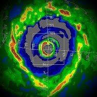
SSTs are marginal 26.5-27°C for what you would expect to support a Category 4. But given the donut annular structure and relative fast motion of 18kts, the eyewall appears to have just enough OHC to maintain intensity. Will be interesting to see how long Dora can keep this up. The TC has generated 20 ACE points so far. SSTs remain around 27°C on a due west heading. However, there does appear to be some increasing easterly trades in a few days south of Hawaii which may impart some mid-level shear, or possibly force surrounding dry air into the circulation.
-

2023 Atlantic Hurricane season
Windspeed replied to Stormchaserchuck1's topic in Tropical Headquarters
I'm wondering if that's going to be a theme of the season. Yes, it's just the beginning of August, but there are bad placements of southern heat ridges and TUTTs to contend with that may very well not go away due to ENSO and strong upper evacuation out of the EPAC, regardless of the +AMO. Beating a dead horse here, but perhaps it bears repeating. That August window of activity I was counting on looks to be getting smaller and smaller. Of course, even if a window of favorable upper pattern evolves over the MDR within the next few weeks as hinted by modeling, we've still got that pesky dry air and subsidence to deal with, which isn't abnormal in early-to-mid August. -
This evening through Tuesday will have better conditions and a moister environment to support development. 95L really fell apart yesterday, though, and with only weak vorticity right now, I'm not sure it will be able to take advantage. Might be dead to rights unless it can reignite some persistent convection along its axis that has separated from the ITCZ. The caveat here is that even if 95L were to grt its act together and develop into a TC during the next few days, it looks like it will ultimately be doomed to hostile conditions in the central Caribbean.
-
No surprise to see Don looking heathier as the core is now riding over an area of ≥26°C SSTs.
-
Not too shabby....
-
Regardless of eventual outcome, there is enough organization here that this likely does close off at the surface and get classification. It is maintaining persistent convection, though displaced west of the nascent LLC. Short-term confidence is high. Long-term confidence is low.
-
There is a very favorable 400-200mb setup north of the Antilles that will evolve if it tracks there despite any SAL. It's the only real intense pattern I can imagine 95L having. Otherwise, it's stiff displacement at 400mb across the central Caribbean, which I just do not see it surviving.
-
It's doing enough to be interesting, so here we go. I honestly don't feel too confident in its future synoptic setup. It needs to gain latitude. There are multiple scenarios north of the Greater Antilles that make this a significant cyclone, but a more southerly track looks like a sheared mess. Too much trade vs. westerlies predominant within the deep Caribbean. If this system is able to close off and stack sooner than later, then perhaps we have a serious TC. Otherwise, it likely gets shredded.
-

2023 Atlantic Hurricane season
Windspeed replied to Stormchaserchuck1's topic in Tropical Headquarters
Cold upper tropospheric temps over Don allowing it to overachieve in sub 26° SSTs. Cooler SSTs due to its own upwelling and development out of a surface trough and sub-tropical cold pool airmass. Still, just enough thermal driven instability now at the surface layer to sustain its core. Don't know if it will reach hurricane intensity, but it does have an eyewall right now. -

2023 Atlantic Hurricane season
Windspeed replied to Stormchaserchuck1's topic in Tropical Headquarters
The Caribbean looks too sheared if the MDR disturbance is driven that far west. It needs to develop and gain some latitude prior to the islands otherwise. A track through or just north of the northern Leewards gives it a better shot. I'm just not expecting much here. Probably another week or two until conditions can temporarily improve for something more serious. -

2023 Atlantic Hurricane season
Windspeed replied to Stormchaserchuck1's topic in Tropical Headquarters
Got a lemon. The disturbance isn't expected to develop until within the central MDR or on approach to the islands if it can hold together. -

2023 Atlantic Hurricane season
Windspeed replied to Stormchaserchuck1's topic in Tropical Headquarters
What will be the state of those vortices though? Will they have upper level support to become hurricanes, or will they be sheared weak systems? It's quite possible we get a number of TCs form in the MDR due to the OHC thermal support, but the WATL and Caribbean may still have unfavorable mid-to-upper level Westerlies. Of course, it only takes one to get into the right synoptic setup that just happens to be favorable for an intense landfall somewhere. Can the record +AMO overcome a strong +ENSO? This is going to be what everyone is focused on for meat of ASO. Big uncertainties on how this plays out with little to no analogs to compare. -

2023 Atlantic Hurricane season
Windspeed replied to Stormchaserchuck1's topic in Tropical Headquarters
Here's a little blurp about the current -PDO state. Obviously the +AMO is still cranking. It really is a blessing that we're staring down the barrel of a a moderate to strong +ENSO. If it were neutral, the 2023 ASO would have been a huge ACE producing behemoth. We may very well still see a few intense hurricanes, as reiterated previously, if something can sneak west into a temporarily favorable upper pattern and low-level easterly steering. -

2023 Atlantic Hurricane season
Windspeed replied to Stormchaserchuck1's topic in Tropical Headquarters
If something does sneak through west and happens to find some good upper support in a westward trajectory, holy cow is the OHC cooking around the Bahamas, Florida and the EGOM. -

2023 Atlantic Hurricane season
Windspeed replied to Stormchaserchuck1's topic in Tropical Headquarters
Garbage post. Keep your BS politics out of it. Phil does not deserve this crap input. He has proven himself to be among the best tropical climatological forecasters alive, and he would easily school you and your lack of knowledge off a cliff. You do not know squat with your ignorance of how this all works. So just stop. -

2023 Atlantic Hurricane season
Windspeed replied to Stormchaserchuck1's topic in Tropical Headquarters
I read the report thoroughly. Phil and his mates are banking on the strong +AMO and record MDR and EATL SSTs, and lower background pressures across the Atlantic Basin to counter a moderate to strong El Niño. He does note: ..and I really enjoy Phil's work, and he is among the best, but be cautious. This seasonal forecast has a higher bust potential than previous seasons. We're in somewhat unknown territory here with anomolous Atlantic basin warmth and favorable AMO versus moderate to strong El Niño. He is banking on Atlantic instability + lower low-level background pressures + weaker trades countering or offsetting an EPAC-induced zonal upper level flow versus diffluence across the Caribbean and WATL basin. That is presently not the case right now. He expects this transition into August, and that may very well be our window and burst of activity this year while the El Niño state is not yet at full strength. However, I would still be cautious. We do not fully know if the 400 to 200 hPa zonal flow will cooperate besides. CSU essentially forecasts that if both basins are warm, that flow should be more favorable than if AMO were negative and Atlantic anomolous warmth was absent. That's not bad reasoning, but it's a bit of a gamble, hence the higher uncertainty. I'll just be blunt. If El Niño becomes strong by September, the Atlantic better have raged out and spit out some numbers and an intense hurricane or two prior to peak. Otherwise, the number of storms won't matter if they're a sheared mess. I think we'll have a much better idea of the statistical and dynamical suites' handle on this battle of zonal flow versus diffluence in a few more weeks. Therefore, CSU's August 3rd update is going to be a lot more important than this one. I still think the Atlantic will struggle during ASO overall. A window of activity will be there in August, but El Niño shuts that down by September. I also look for CSU's forecast numbers to come back down in a future update. -

2023 Atlantic Hurricane season
Windspeed replied to Stormchaserchuck1's topic in Tropical Headquarters
Those storms developed due to favorable WAM and SST anomolies in the eastern MDR. The wave train can persist, and some disturbances may continue to develop in the MDR, but unless mid-to-upper flow cooperates, they are going to be shredded in this pattern just like our previous two tropical storms. Again, not saying something gets in the right place at the right time, and certainly AMO is favorable, but tropical depressions and storms do not high value ACE generate. Flow off of the EPAC and GOM ridge placement is driving a frequently reoccurring pattern of TUTTs and strong westerlies from the Caribbean out over the western MDR and subtropical Atlantic. That is unfriendly for long-tracking hurricanes. Again, we'll see where things stand in a few weeks and see how modeling begins to evolve for August. But a hostile pattern may very well prevail into ASO. A window of activity, if opened, may slam shut fast. -

2023 Atlantic Hurricane season
Windspeed replied to Stormchaserchuck1's topic in Tropical Headquarters
The pattern right now just isn't condusive for Atlantic activity. Way too much mid-to-upper westerlies across the basin. We'll see where things stand in a couple of weeks and leading into August if a window of favoribility can emerge. But that window likely won't persist for too long. Yes, we're only in early July here. But the idea of an active period was banking on development prior to September, as a strong El Niño most likely shuts down the ASO by September anyway. Despite the favorable AMO, the lesson here is cyclical positive SST/OHC anomolies are not going to lead to an active year. You need a favorable atmospheric pattern in place. I'm not saying we don't get a big bad major landfall during an El Niño. Andrew comes to mind. Just takes a lot more luck with placement of TC and a temporary pattern. That being said, I have no confidence in 2023 being active or even reaching normal ACE values. -
LLC has dissipated.
-
- 295 replies
-
- 2
-

-
- severe weather
- frosts
-
(and 5 more)
Tagged with:


