

mitchnick
-
Posts
28,570 -
Joined
Content Type
Profiles
Blogs
Forums
American Weather
Media Demo
Store
Gallery
Everything posted by mitchnick
-
I like that the trough is centered further west than the Lakes because it "should" open up the Gulf and Atlantic for overrunning while remaining cold enough for many for snow/frozen chances. If the trough was over the Lakes, it's cold/dry city outside that LES beneficiaries.
-
Wxmodels DJF 500mb looks better than the free graphics from the Euro site.
-
Euro seasonal for December from MA forum.
-
February Niñas are notoriously warm and dry with few exceptions unfortunately. We'll definitely need to hope late November thru January work out or we're outta luck (short of 1 of those few exceptions.)
-
Yeah. I suspect the new forecast came in cooler thanks to what is showing up in the extended forecasts for December. Unless we get lucky with the strat as you said, the Niña totally collapses into something like a weak Niño, or just plain luck, I'm already brushing up on my 4-letter word vocabulary for February.
-
Comparison to this year's 500mb anomaly forecast for DJF and last year (bottom)
-
Here's a link to all the seasonal Euro if interested. https://charts.ecmwf.int/?facets={"Product type"%3A["Experimental%3A AIFS"]%2C"Parameters"%3A[]%2C"Type"%3A[]%2C"Range"%3A["Seasonal"]}
-
Updated Euro seasonal out today. DJF cooler than last run fwiw.
-
Updated Euro seasonal out. DJF cooler than last run fwiw.
-
I know CAPE is seeing #09 and thinking to himself..."it's in the bag weenies."
-
You do realize that Dr. Sacoransky is an intern radiologist and not a met? Not that one needs to be a met to post about weather as we all know, but you post him often as gospel it seems.
-
I hope the Blue Jays win the WS.
-
New Cansips for November. Scroll forward for rest of the forecast. December looking like many other recent forecasts too. https://www.tropicaltidbits.com/analysis/models/?model=cansips®ion=us&pkg=T2ma&runtime=2025110100&fh=0
-
Cansip gives us our well deserved Modoki Niño for next year too! https://www.tropicaltidbits.com/analysis/models/?model=cansips®ion=global&pkg=ssta_noice&runtime=2025110100&fh=11
- 827 replies
-
- 10
-

-

-

-
New Cansips starts Dec temps with this link below. You can scroll forward from there and switch to H5.. https://www.tropicaltidbits.com/analysis/models/?model=cansips®ion=namer&pkg=T2ma&runtime=2025110100&fh=1 Dry for December, but around normal precip Jan and Feb. Close up for easter US: https://www.tropicaltidbits.com/analysis/models/?model=cansips®ion=eus&pkg=T2ma&runtime=2025110100&fh=1 Fairly typical Nina with February the warmest of the 3.
-
You posted the 15 day change map. The anomaly map looks quite a bit different for better or for worse.
-
Notwithstanding what the Control shows, yesterday's Eps weeklies are not really warm over that same period if you scroll through the link below. https://charts.ecmwf.int/products/extended-anomaly-2t?base_time=202510260000&projection=opencharts_north_america&valid_time=202511030000
-
Just as last year, they keep getting colder as we approach the forecast period. I'll take that as a positive at this point.
-
Um, I would "guess" that the Eps sees what you're seeing too, so...
-
Lots of cooling near Japen of late.
-
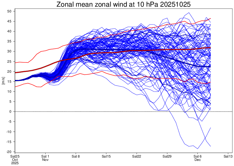
Idk. Over the next 40 day forecast period, the Eps weeklies has winds below normal around 2/3's of the time just eyeballin' it.
-
Oh the Euro Control...if only it could control itself with snowfall forecasts.
-
0z Gfs. Getting ready to switch over in the Metros. How many times on the Gfs would the 390hrs panel, if it existed, be money?
-
With actual SSTA's looking like this, probably safe to say that's unlikely this winter.


