

mitchnick
-
Posts
28,636 -
Joined
Content Type
Profiles
Blogs
Forums
American Weather
Media Demo
Store
Gallery
Everything posted by mitchnick
-
I feel like a new man knowing the Srefs are getting on-board. Giddy up!
-
I like the Eps better. Decently below freezing 850's and a swath of snow seemingly headed right for us.
-
Surface looks mundane...
-
Hey, I'm nearly right smack in the middle of the lighter square in south central PA/MD border to the SW of #46. I'll take it.
-
Canadian ensembles
-
Central PA Fall Discussions and Obs
mitchnick replied to ChescoWx's topic in Upstate New York/Pennsylvania
Hanover -
Entire Eps run droolworthy.
- 750 replies
-
- 11
-

-

-

-
It's been bullish for Tuesday almost from the start. We'll know in a few days if it should be belived in the future.
-
Yep, pigs get slaughtered.
-
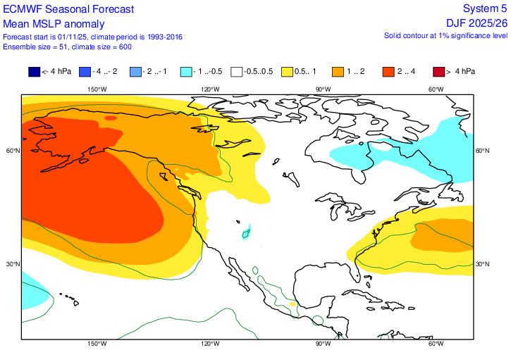
I knew I had seen the surface maps showing surface Highs moving off the coast to our east and NE. I found it. Looks like we may hve to get used to it for the winter if the Euro seasonal is correct. The link below is for the period of Dec-Feb. If you scroll forward to J-M, it's even stronger. As long as we get better cold into the area, we should still have our shots at snow. Next week's problem is only being 3-4 degrees too warm, which is more a function of the early season. https://charts.ecmwf.int/products/seasonal_system5_standard_mslp?area=NAME&base_time=202511010000&stats=ensm&valid_time=202512020000
-
I'm interested is seeing whether the Euro's snowy start to the run will continue to the end as it often seems to do.
-
Pivotal Kuchera
-
Filet-of-sole...and heel!
-
Your head should be in good shape then!
-
Yesterday's PV forecast has it impotent thru early January again.
-
Central PA Fall Discussions and Obs
mitchnick replied to ChescoWx's topic in Upstate New York/Pennsylvania
I'm having some serious doubts for mby. I need a cooling trend to start if not today, definitely by tomorrow. -
Seems a wee bit aggressive for so early in the season in light of the se'ly flow.
-
I mistakenly loaded the Euro AI totals for the 360hr run, so I deleted it. Here are the 0z and 6z for just Tuesday.
-
6z Euro and Eps
-
Just gunna' post this! Certainly, best case.
-
Central PA Fall Discussions and Obs
mitchnick replied to ChescoWx's topic in Upstate New York/Pennsylvania
Climo is always a viable option forecast at 4-5 days. It may be right, but it may be wrong. It's too early on this one. I will say that I'd love to see this a hit along the lines of the Euro 12z because I'm a firm believer that the first threat event gives a strong hint at the winter's seasonal pattern. -
Typical for 4 days out.
-
18z Euro went weak pos, but further south a touch.
-
Looks like my days posting in this forum will be over if that comes close to verifying.
-
Kuchera for better or worse.


