

mitchnick
-
Posts
28,636 -
Joined
Content Type
Profiles
Blogs
Forums
American Weather
Media Demo
Store
Gallery
Everything posted by mitchnick
-
I hope the Blue Jays win the WS.
-
New Cansips for November. Scroll forward for rest of the forecast. December looking like many other recent forecasts too. https://www.tropicaltidbits.com/analysis/models/?model=cansips®ion=us&pkg=T2ma&runtime=2025110100&fh=0
-
Cansip gives us our well deserved Modoki Niño for next year too! https://www.tropicaltidbits.com/analysis/models/?model=cansips®ion=global&pkg=ssta_noice&runtime=2025110100&fh=11
- 827 replies
-
- 10
-

-

-

-
New Cansips starts Dec temps with this link below. You can scroll forward from there and switch to H5.. https://www.tropicaltidbits.com/analysis/models/?model=cansips®ion=namer&pkg=T2ma&runtime=2025110100&fh=1 Dry for December, but around normal precip Jan and Feb. Close up for easter US: https://www.tropicaltidbits.com/analysis/models/?model=cansips®ion=eus&pkg=T2ma&runtime=2025110100&fh=1 Fairly typical Nina with February the warmest of the 3.
-
You posted the 15 day change map. The anomaly map looks quite a bit different for better or for worse.
-
Notwithstanding what the Control shows, yesterday's Eps weeklies are not really warm over that same period if you scroll through the link below. https://charts.ecmwf.int/products/extended-anomaly-2t?base_time=202510260000&projection=opencharts_north_america&valid_time=202511030000
-
Just as last year, they keep getting colder as we approach the forecast period. I'll take that as a positive at this point.
-
Um, I would "guess" that the Eps sees what you're seeing too, so...
-
Lots of cooling near Japen of late.
-
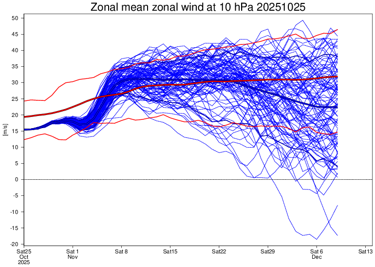
Idk. Over the next 40 day forecast period, the Eps weeklies has winds below normal around 2/3's of the time just eyeballin' it.
-
Oh the Euro Control...if only it could control itself with snowfall forecasts.
-
0z Gfs. Getting ready to switch over in the Metros. How many times on the Gfs would the 390hrs panel, if it existed, be money?
-
With actual SSTA's looking like this, probably safe to say that's unlikely this winter.
-
PDO dropping makes sense in light of 15 day SSTA change.
-
Positive movements here.
-
And that's a positive for most in here.
-
Trough over or near Japan this winter is key imho. It was showing up last year a lot leading to colder temps, step 1 in snow chances. Then we roll the dice on storm tracks.
-
Big difference in the AO region last year to this year.
-
When it comes to money, those guys have itchy fingers for clicking on buy contracts. Frankly, I thought it was too early in the season for big nat gas usage even with BN temps. Guess I was wrong.
-
Nat gas up +11% (with oil down a little) as of this posting. Have there been any updated cold winter forecasts from any of the respected forecasters to anyone's knowledge?
-
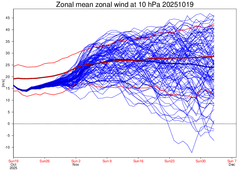
Eps forecast on that tweet was from 10/18. The 10/19 forecast loses most of the above normal mean winds and keeps winds below normal 25+ days over the 40 day forecast. Of course, it'll change again today.
-
If you look at the last 6 weeks of SSTA's at the link below, Enso 3.4 this year has averaged -.3C while last year's same 6 weeks come out to -.416C. It's a little cooler this year, sure. But I'd be a little more cautious about attributing anything to that difference at this point imho. Other portions of the equatorial Pacific over the period are similar in their differences for the most part too. https://www.cpc.ncep.noaa.gov/data/indices/wksst9120.for
-
Thing is, and who knows how much, if any, it matters, but we are likely not going to see an official Niña (5 consecutive tri-monthlies Enso 3.4 average temps at or below -.5C) this winter if consensus modeling is correct. Not that the RONI won't be in Niña territory as well as Chuck's favorite subsurface readings, but it is something that "might" make a difference. In fact, Enso 3.4 temps are struggling to even maintain a -.5C reading over the past month+. https://www.cpc.ncep.noaa.gov/data/indices/wksst9120.for I'll repeat...who knows.
-
Chuck's research shows a bias toward a +NAO during winter when October is negative. I'd like to know where DT gets his idea of the opposite. Don't get me wrong, I'm pulling for DT's opinion to be right. Just wondering the basis of his opinion.


