

Carvers Gap
-
Posts
17,402 -
Joined
-
Last visited
Content Type
Profiles
Blogs
Forums
American Weather
Media Demo
Store
Gallery
Everything posted by Carvers Gap
-
LOL. That is an awesome run. TPV gets trapped and the dam breaks.
-
Impressive, impressive run of the 18z GFS. I also didn't think the Euro Weeklies looked half bad. Its control looks strikingly similar to the current GFS.
-
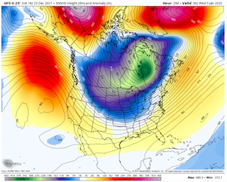
294 on the GFS is how this gets done...just an example and not the gospel. This is the second straight run with something similar.
-
The 18z GEFS is how winter gets unleashed for a time. Impressive trough.
-
Interestingly, the 18z GFS is sort of doubling down on the same deal. It is hammering the Aleutian high(edit).
-
12z GFS... Much different run. Cold has come earlier. EPO ridge is in place after the 1st and AN heights into the GOA. Good trends overall.
-
12z GFS coming in is a bit cooler around December 30th. We will see how that affects the rest of the run. Might be interesting.
-
Three straight days of BN temps at TRI. Will today be a fourth? Modeling pretty much nailed the pattern just prior to Christmas as it did the days prior to the 20th. It likely will nail the pattern after Christmas as well from the 25th to the 31st. We are now watching the pattern just after New Year's. See John's post above. Welcome to the world of extremes. Base warm pattern with interludes of cold(maybe severe cold at times). What we need, to grab a quote from another thread, is an active STJ. Dry conditions are our main nemesis, not just the longer interludes warm wx. Looks like we get another amplification of the eastern trough around Jan 3rd. That looks like a window with some potential. Modeling has been fairly adamant that we will see a trough roll through then. So, it is progressing along. What happens after that potential cold shot is open for much debate. January is one of those months that doesn't require strong BN temps for snow. Even slightly AN temps will get the job done.
-

Fall/Winter Banter - Football, Basketball, Snowball?
Carvers Gap replied to John1122's topic in Tennessee Valley
Vols with a big win over Arizona. BIG! -
Been out finishing up some Christmas shopping. Modeling still looking good.
-
And that would make some since given what we are seeing in the LR.
-
Waiting for the MJO to roll right now. We may be looking at a pattern change, but more likely a relaxation of some sorts and full change later in January. However, what is on most modeling this morning is the first hints of the current pattern beginning to break down. WxBell still has the PNA negative on its run, but that is a PNA ridge that pops on the 6z GFS. Oddly, and I thought about this yesterday, but wasn't brave enough to post it. It is like the -NAO(which normally we want very strong) is causing a buckle which locks the cold out West, because it is in conjunction with the Aleutians high. When the NAO gets out of the way, it is like a dam breaking. That said, it does its work by forcing the cold south. Without it, the cold would slide across the northern border states. Not saying that is the gospel, but it did cross my mind. Reading through the MA forum which has a great winter thread going as well, they mention the NAO is more strongly correlated to eastern cold during mid and later winter.
-
The 6z GFS is nearly a pattern reversal to an eastern trough. The Euro control was nearly the same thing. Really good trends in modeling overnight. After reading John’s post, I agree. Looks like a 6 which is now moving to a 7. Have to think the typhoon was causing havoc last week.
-
0z ICON and CMC sneak a cold front through on the 29th. Worth noting, because that is different than what we have been seeing.
-
I think we can deal with the Aleutian ridge. It is actually common during many good La Nina winters. The GFS for the past 2-3 runs has shown it basically working to connect over the top with the NAO. If that occurs the TPV will be forced south into a broad trough between the Rockies and the Apps. I take the 0z GFS as is....that would likely be an overrunning event if real. Great discussion, everyone....
-
It was not as warm here today as I thought. Maybe I have seen all of these warm maps, and just got ahead of myself. Neighbor of mine had his fireplace going all day pretty much.
- 167 replies
-
- 1
-

-
- frost
- cold front
- (and 4 more)
-
Definitely a lot of shoveling going on! LOL.
- 167 replies
-
- 1
-

-
- frost
- cold front
- (and 4 more)
-
We will see if it is right, but the 18z GEFS is an outlier now among modeling...It may be leading the pack. Not sure.
-
Good point. This is the most recent update. What do you make of the third bulleted point in conjunction with Aleutians ridge? MJO indices continue to depict an enhanced West Pacific signal, and upper-level velocity potential anomalies show the enhanced phase crossing the central Pacific. The amplitude of the MJO has decreased, and the RMM-based MJO index depicts little eastward propagation over the past week due to interference from the La Niña base state and Rossby wave activity. The GEFS and ECMWF ensembles depict persistent enhancement over the West Pacific, with little to no eastward propagation. It is possible that this signal may reflect a temporary weakening of the La Niña atmospheric response. There is considerable uncertainty regarding the potential for this MJO event to remain coherent as it crosses the Pacific.
-
Reading reports in the SE forum of steady, frozen precip falling in western NC.
- 167 replies
-
- 2
-
-
- frost
- cold front
- (and 4 more)
-
After 300, the Alaska ridge slides southwest into the GOA. Cold air jettisoned from the Arctic headed due south. Very cold pattern beginning around 282 for most of the Lower 48. Like a dam breaking that run.
-
18z GFS again moves the Aleutian ridge....this time it builds monster heights into Canada. Looks very much like the Canadian ensemble and maybe even the Euro control. Good trend continues.
-
The 18z GFS has the cold intrusion now on Jan 2nd. We will see if that holds during future runs.
-
And the GFS at 18z is back on the cold train. That is quite a cold look around Jan 3rd.
-
I am tempted to post the temp anomaly map for the Euro control at 360...super tempted. The entire US is much below normal. Looks like the Canadian ensemble, and 12z GFS. I lean warm, but barely warm in my thinking. I wouldn't be shocked for the overall high temp in January and low temp in January to have 80 degrees between them. All it is going to take is one strong cutter into the Plains....and it is going to get super cold here.
