jm1220
-
Posts
25,030 -
Joined
-
Last visited
Content Type
Profiles
Blogs
Forums
American Weather
Media Demo
Store
Gallery
Everything posted by jm1220
-
UK is fine for the city and S/E but an outlier. Wouldn't be worried about it.
-
The Dec front end batch was good for a few hours but then went shredded which allowed the warm air to take over when the precip finally did restart, we wasted up to 0.5" as rain. Hopefully this can be a colder version of that storm, if not for that it would have been easily 12"+ in my backyard.
-
If there's a story so far tonight I'd say it's for a crazy fronto band to come through and dump very heavy rates especially from eastern NJ on east, when earlier it seemed like it would be more modest but longer lasting on the easterly mid level jet. NW would pile up a bit less snow but have a CCB feature with good ratios sit overhead while there's a relative dryslot over the immediate metro area.
- 2,426 replies
-
- 1
-

-
- heavy snow
- ice pellets
- (and 3 more)
-
There's a piece of energy that dives down the trough and enhances the coastal low so much that it lurches it north enough to have SE Mass be mostly rain on that run I'd say. GGEM has the low near Marthas Vineyard. The prolonged easterly mid level flow doesn't help and brings warm air in to start. The GFS v16 keeps that area plenty cold and buries them just like us. So like I said, tomorrow will be interesting.
-
Watching closely .. February 1-3rd for moderate to major coastal event
jm1220 replied to Typhoon Tip's topic in New England
Amish Annihilation. -
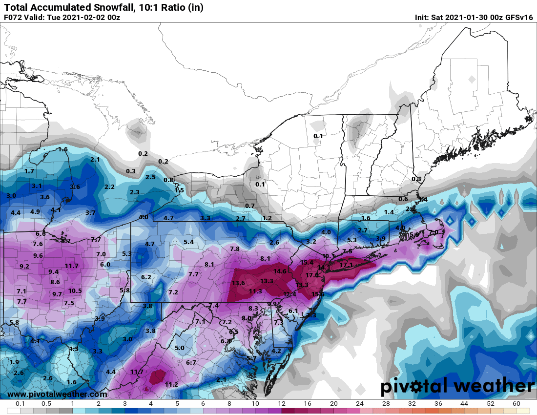
Final for that run (and it wasn't, there was minor additional even after this panel).
-
Story's not close to being written on this yet. I wouldn't count anyone in this subforum at least as really being out. Might be shaping up as down here a crazy 10-12 hour burst of our snow and well NW a lighter 18 hour snow with the CCB feature.
- 2,426 replies
-
- 1
-
-
- heavy snow
- ice pellets
- (and 3 more)
-
Watching closely .. February 1-3rd for moderate to major coastal event
jm1220 replied to Typhoon Tip's topic in New England
The v16 did a lot better on the 12/17 event overall than the retiring GFS, but the retiring GFS had us down here quite a bit colder and busted. Reversed this time with these-old GFS has the crappy thermals and the v16 annihilates us and most of you guys too. . -
Watching closely .. February 1-3rd for moderate to major coastal event
jm1220 replied to Typhoon Tip's topic in New England
Snowgoose FTW? (sorry I had to lol) -
Oh yes, wow and it's still snowing here. I really hope this model has a clue, it did better for the 12/17 event than regular GFS.
- 2,426 replies
-
- 1
-
-
- heavy snow
- ice pellets
- (and 3 more)
-
This isn't really like Jan 2016. That was more miller A and El Nino fueled-you could track the moisture from it right to the tropical Pacific. This is more miller B-coastal transfer from a primary. It won't make it a lousy event but spawned differently.
-
I think in the end you'll be fine (you're in Dutchess County N of I-84? If that far maybe/maybe not). Maybe not the highest amounts but good ratios will help and prolonged duration of lighter snow it looks like. These NW bumps seem to happen every time. I at least don't think you get shut out.
-
Maybe the rain will taste like strawberries like on the commercial.
-
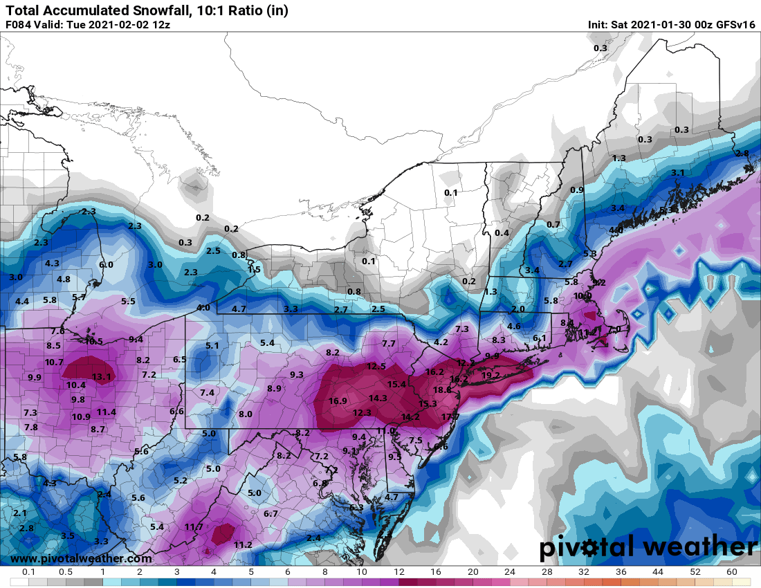
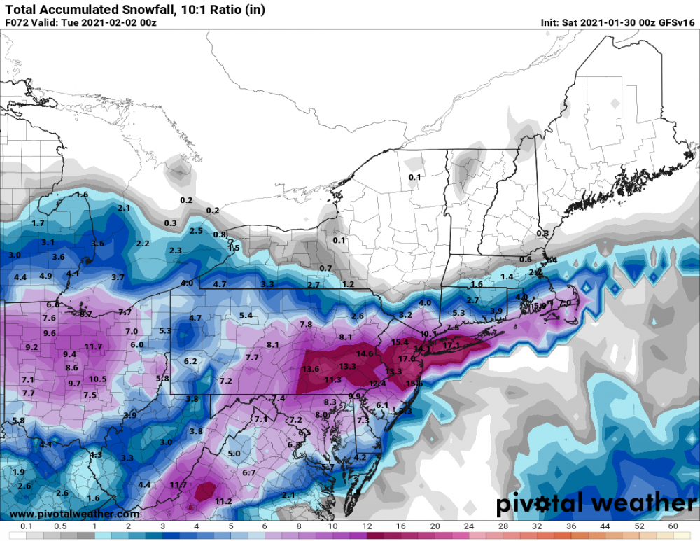
GFS looks quite nice to me for most, best is focused on the coastal area but it trended NW again. Has a crazy Monday afternoon/evening snow burst that comes through on the easterly 850mb jet for coastal areas. It peters out north of the city. We'll see how far north that crusher snow batch can make it on that easterly jet along with max ratios.
-
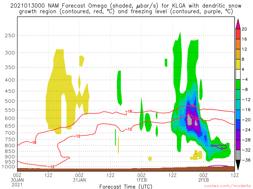
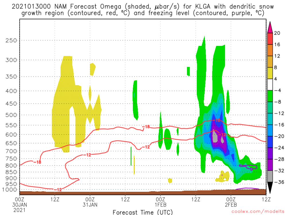
Also note in purple the freezing layers that could show what precip is left after 0z Tue could be sleet or sleet/rain mix (on this NAM run). Notice the small mid level warm layer and surface above freezing. Thankfully the crazy lift and heavy precip comes in before any warm layers arrive and the lift (and real precip) is gone by then.
- 2,426 replies
-
- 1
-
-
- heavy snow
- ice pellets
- (and 3 more)
-
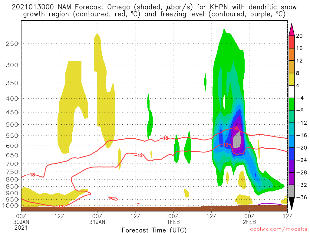
For White Plains-that's perfect for high ratio snow. So for NYC that's as far north as you'd want this to go on this NAM run.

- 2,426 replies
-
- 1
-
-
- heavy snow
- ice pellets
- (and 3 more)
-
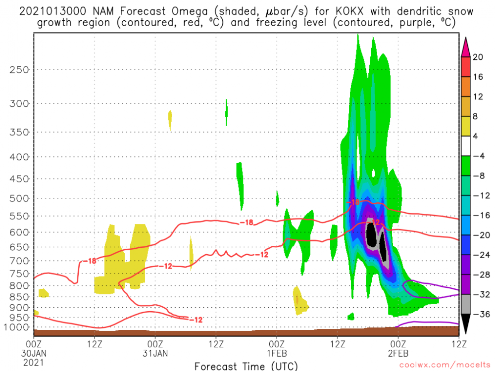
For NYC and LI on the 0z NAM the max lift is just below the -12 to -18C layer so ratios could be decent but not maximized (on this run). For best ratios you want the lift centered between the -12 and -18.
- 2,426 replies
-
- 2
-
-
- heavy snow
- ice pellets
- (and 3 more)
-
I was never worried much about suppression, it was in the back of my mind this morning but it looks like this one's following the trend of 90% of storms. Question now is when the trend stops.
-
Yeah I'll definitely take that lol. And it's still snowing here when the run ends, there's a CCB feature overhead.
-
Yep, that's about picture perfect for NYC for big impact. Now we see how much more NW trend we have left to go in other models.
- 2,426 replies
-
- 1
-
-
- heavy snow
- ice pellets
- (and 3 more)
-
That's about as far north as I want the NAM for my backyard. The mid level low tracks are still good for coastal areas but there's a dryslot and mild 850mb air that makes it to SE areas. Hellacious front end thump though before anything like that which the 12"+ amounts come from.
- 2,426 replies
-
- 2
-
-
- heavy snow
- ice pellets
- (and 3 more)
-
The slow movement means the snow will linger quite a while. The heavy stuff shuts off once the east mid level flow backs down but there should be some semblance of CCB for some additional light amounts.
-
Yeah, that’s about as good as it gets. Far NW is still fringed but that’s a crusher for 90-95% of us.
-
That is one crazy 850mb easterly moist flow coming in on this. This’ll be a very nice event where that can be maximized and the cold air stands firm. It’s not a bombing out low where there’ll be 3-5”/hr bands I think but we can rack up totals well over a foot over the duration it’ll last. I’d pay more attention to where that easterly jet gets than the snow maps necessarily. The Euro that run as is gets the mix line close to the twin forks for a time and seems like it changes SE MA over. Hopefully it doesn’t amp much more.
- 2,426 replies
-
- 2
-
-
- heavy snow
- ice pellets
- (and 3 more)