

jm1220
-
Posts
26,172 -
Joined
-
Last visited
Content Type
Profiles
Blogs
Forums
American Weather
Media Demo
Store
Gallery
Everything posted by jm1220
-
It’s probably overdone but the wind threat only seems to be increasing over time. 70mph gusts would be quite damaging especially since they’re coming from an onshore direction and would pile in water.
-
Geez, 80mph gusts into NYC?
-
I’d hoist high wind watches for LI/NYC for Monday if I was Upton. It’s becoming pretty clear this is a threat. Coastal flood watches as well.
-
For sure. When you see a roaring SE mid level jet like models are showing, a lot of the snow maps on the SE edge are going to be overdone because you know the sleet line is going to explode northward. On the west side of the storm though there definitely will be an axis of heavy snow totals since those winds slow down and cause a region of quickly rising air where the deform axis forms. Unfortunately that’ll be way far west-if you believe the NAM it’ll be from E OH to Buffalo up into Canada. Concerning how much of that jet is shown to mix down near the coast. If it coincides with high tides there could be some serious problems in vulnerable flooding spots since ESE winds will pile in lots of water.
-
NAM can be overdone with the mid level warmth but it’s usually closer to reality than the globals.
-
NAM is so warm in the mid levels that it switches almost the whole state of PA to an ice storm. I have to think that’s a little extreme but goes to show that anyone in our area that starts as snow, it’ll be quite brief.
-
Yikes. 70 mph right up to the coast. There’ll definitely be outages and flooding if that happens. I’ll be in Long Beach this weekend, could be some washovers.
-
We’re not really concerned with the surface low tracks at this point. Pay a lot more attention to the mid level lows which still look to go well inland. They also have plenty of time before getting here to wrap in warm air since the storm is maturing. Models still show a very powerful SE jet at the mid levels which will warm those layers up quickly.
-
It’s not news that NYC is generally a lousy place for snow. Central Park averages 30” annually (boosted considerably by how lucky we’ve been in the last decade) while the Catskills average 70+. Syracuse averages over 120”. I noticed @sferic moved to Cicero near Syracuse. Hate it that much, do what he/she did. We have boom and bust cycles lately where we have a monster 30” Feb 2021 or little/nothing.
-
And this is a big storm even if for most of us it’ll be rain. That SE jet means business and the Euro had gusts over 70 mph near the coast. We might have moderate to major coastal flooding in spots too. That’ll be the main story in this sub forum.
-
From cold to milder within the upcoming pattern. Usually big storms happen when these patterns shift.
-
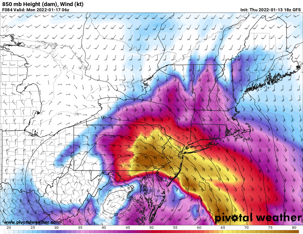
All you need to know about that NAM run. Is it overdone-maybe, but it doesn't matter that the sfc low track went SE. That SE jet at 850 is an inferno of mid level warmth coming in. It actually has a good chunk of the event in central PA as freezing rain verbatim and the good snow is in E OH/NW PA. For most of us it's heavy rain since that'll also transport lots of Atlantic moisture and there could be some very strong wind if the jet can mix down. 925mb winds are also upwards of 75kt.
.thumb.png.69f0781143cc8f7bd81bd1fef613f83d.png)
-
We’re probably beyond the point where it can make much of a difference snow wise near the coast. Maybe the high can hang on a little longer and make it a 1-2 hour period of good snow but we’d need a major change to get it to where it’s a snow event near the city. We’d need a couple hundred mile shift SE with all the major mid level features.
-
Yep. The 700mb low is very wound up by the time it reaches us which means dry air has plenty of time to wrap around it. It'll be a mature cyclone and starting to occlude when we're in the thick of it. There'll definitely be heavy rain/precip for a while though on that 850mb/700mb SE jet off the water.
-
Shadowing=downsloping that would weaken any precip. Basically you wouldn't want to go to the west slopes of a mountain/hill range in this given that the flow is coming out of the east.
-
With this map at 850mb you aren't staying snow for very long in this subforum. It shows 70-80 knot ESE flow at that level. 700mb shows 60-70 knot SE winds. That warms mid levels in a hurry. I don't think it rains well inland, like near I-84 but prepare for a letdown if this happens and you're expecting much snow.
-
I'm more interested with that in the metro area-this possible squall line and any coastal flooding. Multiple models are showing 60+mph with that.
-
Those snow maps are likely showing a lot of sleet as snow until you're well north in New England or west in PA/NY. The mid level low tracks are horrible- winds at mid levels are out of the E/SE and strengthening. And the GFS usually doesn't see the mid level warming soon enough. NAM is better with that which we'll see a few runs from now (if the overall setup doesn't improve). I've gotten burned numerous times with seeing big snow totals on maps with bad mid level low tracks. It'll change over way sooner than it thinks now.
-
NAM actually is very amped. Maybe not as super amped as it can be but it's amped enough to change everyone east of the Allegheny spine in PA to sleet and dry slot, as the deform axis/heavy snow is over OH.
-
St Patrick’s Day 2007? I remember that well. VD 2007 was sleet and freezing rain on the coast. This won’t be a sleetfest on the coast like those. There’s a strong easterly fetch off the ocean and retreating high. You want the high stuck in place and northerly winds for CAD. Those aren’t what we want to keep cold air where we are. Models have us getting into the 40s during the storm.
-
I’d call it a win here to see an hour of snow before rain. Although if it gets washed away anyway I don’t really care. The main story here will be coastal flooding as Rjay mentioned. Some of the back bays and usual spots could get dicey. Inland that can hold onto the cold air will see a couple hours of snow then a ton of sleet. Probably a few inches of mess by the end. You’ll really want to be far west in upstate NY or PA to get much snow.
-
If the winds are coming from off the ocean there won’t be CAD at least where you and I are. Well inland sure. But I think the snow maps showing 6+ for N NJ and S NY are probably overdone. A lot would be sleet.
-
If those mid level lows are still west of me and the high is still getting chased out, I couldn’t care less about minor changes. Might just make the rain a degree or two colder.
-
I’m actually happy for the central PA crowd that should get a significant to major event here. They very rarely have gotten big snow events over the past 15-20 years other than a couple of exceptions like 3/14/17 and last Dec’s storm. And the ski resorts are begging for this.

.png.d16b125e41ef35fa383e5e9beb07b77e.png)

