

NC_hailstorm
-
Posts
2,649 -
Joined
-
Last visited
Content Type
Profiles
Blogs
Forums
American Weather
Media Demo
Store
Gallery
Everything posted by NC_hailstorm
-
33.4 rain/snow mix can't get a complete changeover yet.
-
Snow here,large flakes. 34.1
-
Clouds rolled in fast after a clear morning,mostly cloudy and 39.6 26.4 for a low.
-
Good grief that 18zHRRR is impressive.Still wasn't done at 48 hours.
-
Have been noticing the Euro forecast is ever so slightly trying to pull this MJO into phase 1 over the last 5 or so days.Even better look if that happened so things still on schedule. Carry on.
-
Funny how no model or any forecaster saw any of the impressive blocking so far,NOBODY but the solar signals screamed blocking.It is fighting a healthy La Nina so we do have a battle going on right now. About to exit the latest solar cycle and given the usual 10 day lag(give or take a few days)things should improve with tropical forcing and MJO help.This latest cycle also should finish off the PV for a SSW soon,Euro is trying to push into phase 2 MJO which is usually a cold look for the east around 10-12 days.AO still looks to stay quite negative as does NAO so as long as that blocking shows up you are still in the game. Would like to see that PV enter the troposphere by Jan.25th or so on our side of the continent,another cycle around then would most likely pull it west if it entered later. I'm not throwing in the towel yet I'll wait a while.Just my opinion.
-
20.5 here this morning Some monthly temps for the region,guess who's still above average. GSP -1.3 HKY -0.7 AVL -0.8 RDU -0.2 GSO -0.8 FAY -0.2 CAE -1.3 CLT +0.7
-
Little chilly this morning,14.4 for a low.
-
Front just arrived here,howling winds all of a sudden from the WNW.Good 8 degree drop in about 15 or 20 minutes.
-
Canadian looks similar at that range so Euro is not alone.. Watch that shortwave diving in the 4 corners area around day 7/8.
-
GFS still going for that SSW in the long range,the attack begins today or tomorrow with higher solar input. When and if it occurs you have to watch where that PV sets up .You don't want that getting stuck in central,SW Canada that happened a few years ago and hurt more than helped and I'm talking about down at 100hpa levels. Just my opinion.
-
Ice Time? Dec. 16ish Possible CAD Event
NC_hailstorm replied to Tar Heel Snow's topic in Southeastern States
Lights out for me. -
November’s AMO index saw a sharp decline to 0.125. Good sign for AO/NAO but hasn't been negative since December 2018 and we know what happened then.Also some warmer water showing up around Greenland. Get another attack on the Polar Vortex starting Dec.20th in my opinion.
-
Well the most important thing is....Who's gonna start the thread?
-
Looks right it is forecasted to push to 100mb.Everything I read is you want easterly at 30mb maybe he wants it at 100mb too.
-
Anyways,my two cents on winter.Good and Bad. Good: There's always a 3 to 4 year lag on low solar/sunspots so just coming into that,blocking Ascending phase of the solar cycle,blocking QBO-Bad now could be good soon very deceiving only a small patch of westerlies is at the equator with EQBO forecasted to push down to 30mb.Weakens PV.blocking. BAD ENSO- La Lina Usually southeast ridging .west trough. Gulf Stream-Tick better than last year but still not good.Looking for colder waters from Newfoundland/Nova Scotia/down to NC,Warm around Greenland..NAO is what you look at here. About it .
-
Sure come on up get away from all the terrible Mooresville traffic.
-
Looks like we'll get some fairly potent MCS action over the next 24 hours.The HRRR has the first arriving overnight with two more crossing Saturday afternoon. Damaging winds the big issue most likely,they are really flying moving SE.
-
December 8-10, 2018 Winter Storm
NC_hailstorm replied to Orangeburgwx's topic in Southeastern States
Might wanna save this,850mb at 10 AM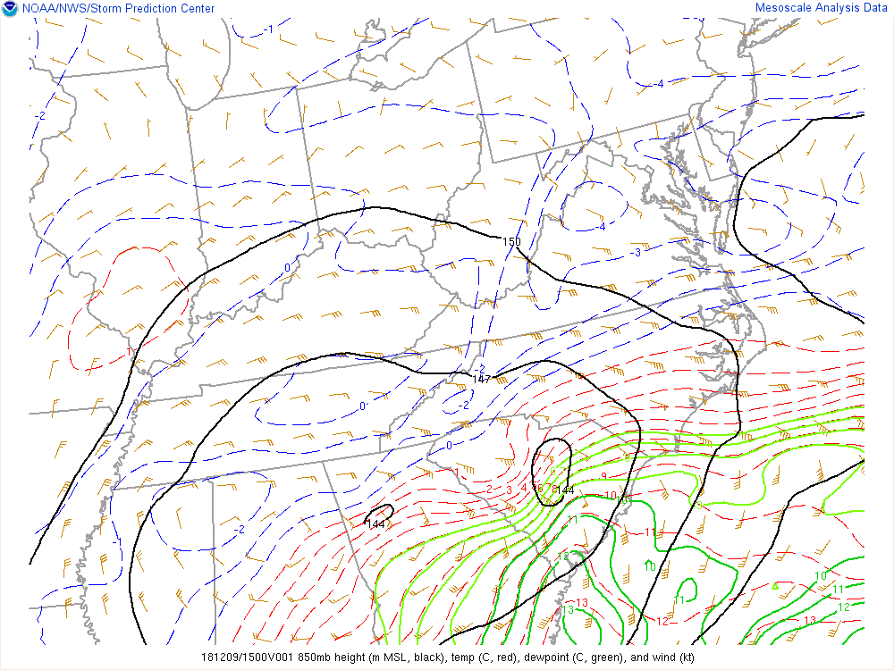
-
December 8-10, 2018 Winter Storm
NC_hailstorm replied to Orangeburgwx's topic in Southeastern States
Right now I'd say the Euro and the FV3 look pretty close with the cutoff line somewhere along highway 73 in the southern piedmont of NC. Sleet will probably mix in everywhere time to time with warm pockets coming through but more south of there. Carry on. -
December 8-10, 2018 Winter Storm
NC_hailstorm replied to Orangeburgwx's topic in Southeastern States
The FV3 has been running pretty well lately by the verification scores so we'll see. -
December 8-10, 2018 Winter Storm
NC_hailstorm replied to Orangeburgwx's topic in Southeastern States
Heights are a little lower on the Ukie with the 570dm deeper into the upstate and south of CLT this run compared to 42. It's only 20-25 miles maybe but every mile counts now. -
December 8-10, 2018 Winter Storm
NC_hailstorm replied to Orangeburgwx's topic in Southeastern States
I might save this one.Day 8 Euro.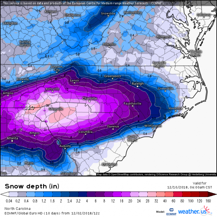
-
Think I was looking at 12km but yeah you're right.
-
The 18z NAM continues to cut these rainfall totals in NW NC,3''-5'' across there on this run with a big cutoff just SE of CLT where 9'' plus are.Might be a bit light but we'll see. Carry on.


