NC_hailstorm
-
Posts
2,650 -
Joined
-
Last visited
Content Type
Profiles
Blogs
Forums
American Weather
Media Demo
Store
Gallery
Everything posted by NC_hailstorm
-
Mid to Long Range Discussion ~ 2024
NC_hailstorm replied to buckeyefan1's topic in Southeastern States
Good grief a 972 low on the Canadian. -
Mid to Long Range Discussion ~ 2024
NC_hailstorm replied to buckeyefan1's topic in Southeastern States
Don't know if it's right but a hit on the Icon tonight....... -
Mid to Long Range Discussion ~ 2024
NC_hailstorm replied to buckeyefan1's topic in Southeastern States
Canadian might be a hit for western NC,foothills,western piedmont. Heck of a storm off the coast. -
Mid to Long Range Discussion ~ 2024
NC_hailstorm replied to buckeyefan1's topic in Southeastern States
Just from what I'm seeing at 144,the UKMET,ICON,and Canadian have more shortwave energy further north in CO,OK.and northern TX. Euro a tick south of there,GFS way way south of there. Oh and the GFS is scoring very poorly lately,way behind the other three. NOAA/NWS Headline Scores: ACC 31 Days -
February 11-12 ULL Winter Storm
NC_hailstorm replied to Upstate Tiger's topic in Southeastern States
Good news I have the S word in the forecast now Sunday Snow before 10am, then rain. High near 39. Breezy. Chance of precipitation is 100%. -
Mid to Long Range Discussion ~ 2023
NC_hailstorm replied to buckeyefan1's topic in Southeastern States
Yep that wacky 0z GFS is dropping that PV into the USA late in the run. -
Mid to Long Range Discussion ~ 2023
NC_hailstorm replied to buckeyefan1's topic in Southeastern States
Think that was the 1st Euro run that dropped the polar vortex into the USA,GFS has already had a few. -
Mid to Long Range Discussion ~ 2023
NC_hailstorm replied to buckeyefan1's topic in Southeastern States
Euro is bringing the hammer at day 7,polar vortex dropping into the upper midwest with strong ridging on the west coast. -
Mid to Long Range Discussion ~ 2023
NC_hailstorm replied to buckeyefan1's topic in Southeastern States
No worries the 18z GFS is going all 1899 again lol. -
Mid to Long Range Discussion ~ 2023
NC_hailstorm replied to buckeyefan1's topic in Southeastern States
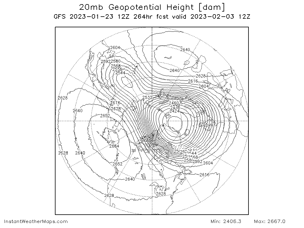
The 12z GFS has a strat split/reversal up at 20mb at day 11.GaWx is right a technical SSW is a reversal at 10mb but anything above 30mb can shake up a pattern from what I've read.Carry on.
-
Mid to Long Range Discussion ~ 2023
NC_hailstorm replied to buckeyefan1's topic in Southeastern States
Hmm,looked like the Canadian today was trying to go all 1899 late in the run.Every now and then you get a run from all models of a wicked cold shot but I'm not sure how far southeast it gets. -
Mid to Long Range Discussion ~ 2023
NC_hailstorm replied to buckeyefan1's topic in Southeastern States
Hmm,I see the GFS went all 1899 on us today.Might wanna save that one. -
Mid to Long Range Discussion ~ 2023
NC_hailstorm replied to buckeyefan1's topic in Southeastern States
The UK has the shortwave at day 6 in west central New Mexico,very close to the Canadian position maybe even a tick southwest of it. -
Mid to Long Range Discussion ~ 2023
NC_hailstorm replied to buckeyefan1's topic in Southeastern States
That's a large hit on the Canadian tonight,looks like the Euro. -
Mid to Long Range Discussion ~ 2023
NC_hailstorm replied to buckeyefan1's topic in Southeastern States
Agree. The fact that the GFS has some sort of low in the ballpark as the Euro/EPS is encouraging.Adjustments/tweaks can be made. -
Mid to Long Range Discussion ~ 2023
NC_hailstorm replied to buckeyefan1's topic in Southeastern States
Euro and EPS look pretty good at day 7- 8,even the GFS is similar with the low placement it's just too warm for frozen at the moment. MJO looks very favorable in about a week,(p8,p1)AO is still negative,and the NAO ticking to neutral.Time to track. -
Mid to Long Range Discussion ~ 2022
NC_hailstorm replied to buckeyefan1's topic in Southeastern States
Ukie looks like it might hit,little quicker than the GFS in regards to timing. -
1'' here,23.9 light snow.
-
January temps updated. AVL 0.0 CLT +2.5 GSP +1.1 HKY +2.1 GSO +1.5 RDU +1.8 FAY +1.6 CAE +1.9
-
Mid to Long Range Discussion ~ 2022
NC_hailstorm replied to buckeyefan1's topic in Southeastern States
0z UKMET looks like a hit day 5,little more east . -
Mid to Long Range Discussion ~ 2022
NC_hailstorm replied to buckeyefan1's topic in Southeastern States
Late phasing,,eastern sections doing a little better but have a storm. -
Mid to Long Range Discussion ~ 2022
NC_hailstorm replied to buckeyefan1's topic in Southeastern States
0z Canadian is a hit,day 5 -
Mid to Long Range Discussion ~ 2022
NC_hailstorm replied to buckeyefan1's topic in Southeastern States
0z GFS is a hit,phased storm at day 5. -
Winter Storm Izzy Obs Thread
NC_hailstorm replied to Prismshine Productions's topic in Southeastern States
Light snow 28.0 Haven't seen any freezing rain all day which is a little surprising. 4.5'' total -
Winter Storm Izzy Obs Thread
NC_hailstorm replied to Prismshine Productions's topic in Southeastern States
A light snow/flizzard,very fine flakes. 27.1 Still around 4''