andyhb
-
Posts
20,419 -
Joined
-
Last visited
Content Type
Profiles
Blogs
Forums
American Weather
Media Demo
Store
Gallery
Everything posted by andyhb
-
Let's take a box average including ORH, PVD, and BOS at 66 hours...
-
Absolute crush job.
-
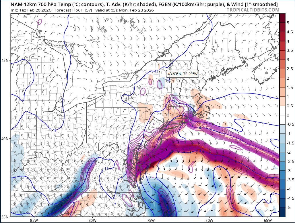
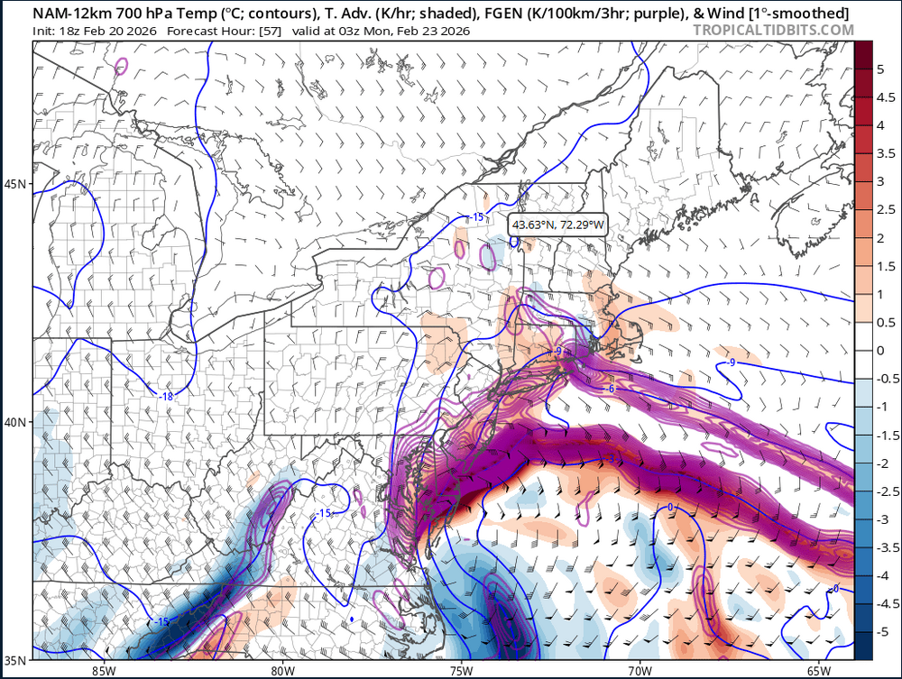
One of the craziest FGEN signals I’ve ever seen off that 18z NAM. Like wtaf.

-
This is one of the dumbest FGEN plots I’ve ever seen on the 18z NAM.
-

January 30th- Feb 1st ULL and coastal storm obs
andyhb replied to JoshM's topic in Southeastern States
MHX office just reported 15” snow depth. With all of the blowing/compaction/etc, that’s probably pushing 18” in total snowfall. -
January 30th- Feb 1st ULL and coastal storm obs
andyhb replied to JoshM's topic in Southeastern States
Those totals seem a bit low to me given New Bern was in the double digits last night. Have these been updated? There’s 15-20” reports coming from the areas near and south of Jacksonville. -
January 30th- Feb 1st ULL and coastal storm obs
andyhb replied to JoshM's topic in Southeastern States
Whopper of a deformation band setting up from Jacksonville to Greenville in E NC right now as the low rapidly deepens with the trough going negatively tilt. Have to think 20"+ or perhaps even two feet is on the table for some. -
January 30th- Feb 1st ULL and coastal storm obs
andyhb replied to JoshM's topic in Southeastern States
This is going to be the 21st Century winter storm of record for many in the Carolinas ultimately, especially with blizzard conditions occurring at the coasts. -
January 30th- Feb 1st ULL and coastal storm obs
andyhb replied to JoshM's topic in Southeastern States
This map is going to look a lot more impressive when it is all said and done. Will be historic for the NC coastal regions as well. -
As an onlooker from outside the area perusing, I think I’m losing my mind reading your posts. Any storm that gives ORH and BOS 22”+ is going to be remembered by many.
-
1/24-1/25 Major Winter Storm - S. IL, IN, and OH
andyhb replied to A-L-E-K's topic in Lakes/Ohio Valley
Queens Park just reported 5.5” in the last hour, unbelievable. -
1/24-1/25 Major Winter Storm - S. IL, IN, and OH
andyhb replied to A-L-E-K's topic in Lakes/Ohio Valley
Im glad they’re also measuring at Queens Park because YYZ’s iffy measurements are notorious. -
1/24-1/25 Major Winter Storm - S. IL, IN, and OH
andyhb replied to A-L-E-K's topic in Lakes/Ohio Valley
What is happening in Toronto/vicinity right now is incredible. 3-4”/hr rates for hours as a heavy LES band is parked across the metro due to easterly flow from the main synoptic storm. Could break the all time record there in fairly short order. -
Hundreds of miles of rippage.
-
1/24-1/25 Major Winter Storm - S. IL, IN, and OH
andyhb replied to A-L-E-K's topic in Lakes/Ohio Valley
That band from S IL through S IN into SW OH between Cincinnati and Dayton is a monster, spreading NE towards Columbus too. -
1/24-1/25 Major Winter Storm - S. IL, IN, and OH
andyhb replied to A-L-E-K's topic in Lakes/Ohio Valley
Looks like Ohio’s biggest storm in quite awhile. Notable banding setting up initially north of Cincinnati right now extending all the way back through S IN and IL. -
Y’all are going to win 2015 style on this one.
-
Good lord…
-
That second GFS storm is an absolute titan, Cat 5 NESIS/RSI type stuff.
-
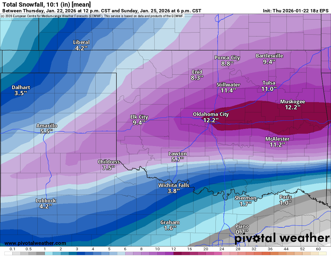
MO/KS/AR/OK 2025-2026 Winter Discussion
andyhb replied to stormdragonwx's topic in Central/Western States
The Euro/EPS really do seem to want to lay the smackdown on Oklahoma. 60-80% chance of a foot or more at 10:1 ratios on the 00z run. Reminder that the greatest snowfall in OKC's history is GHD 2011 with ~14", so we're talking easily in historic territory if most of this stays snow/avoiding dryslots/etc.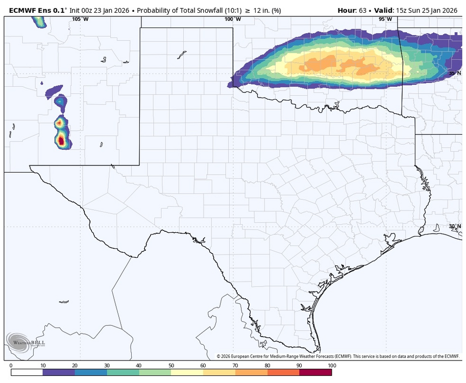
-
MO/KS/AR/OK 2025-2026 Winter Discussion
andyhb replied to stormdragonwx's topic in Central/Western States
Monstrous storm for OK on the 18z Euro, particularly the I-44 corridor. 1.2-1.5" liquid for both metros with temps in the single digits on the backside. 18z EPS is also extremely impressive.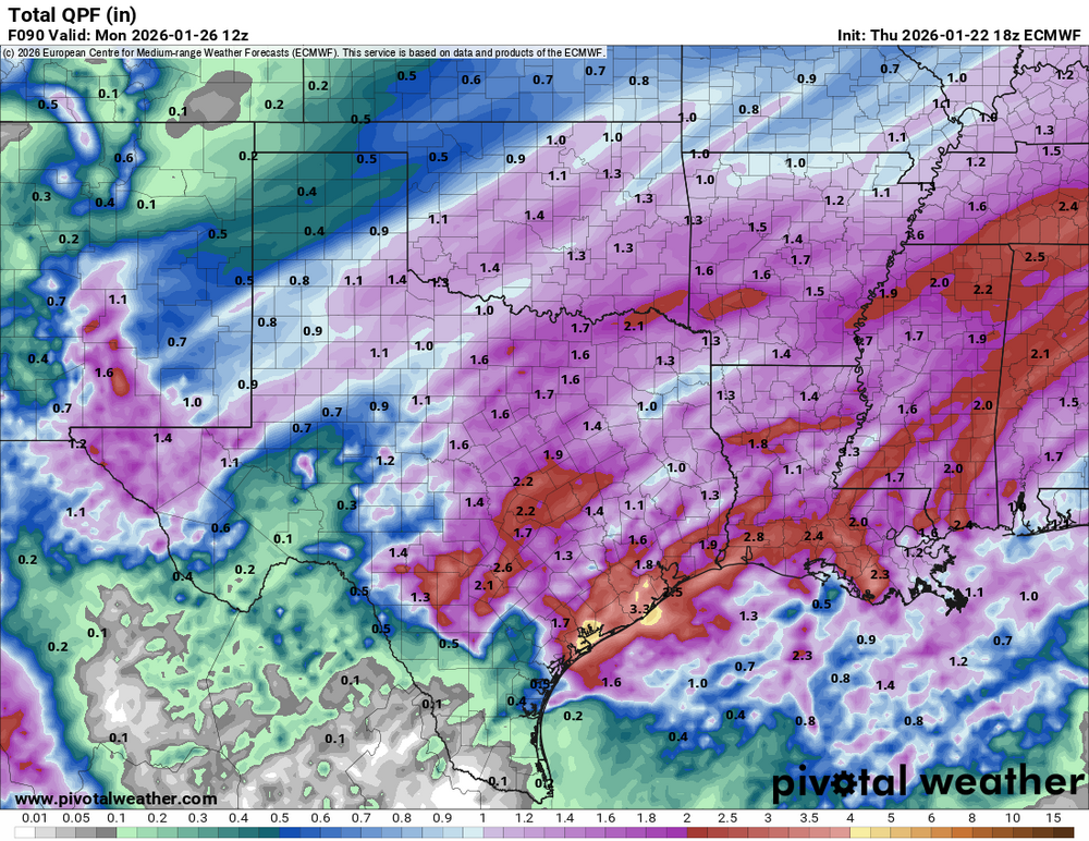

-
12z Euro essentially stalls the coastal as the primary ascent from the jet results in redevelopment closer to the coast, long period of high ratio fluff results and gets the entire region above 1" QPF/15" on Kuchera.
-
Doesn’t get much more favorable than that tbh from a large scale pattern standpoint. That blocking is incredible.
-
1/24-1/25 Major Winter Storm - S. IL, IN, and OH
andyhb replied to A-L-E-K's topic in Lakes/Ohio Valley
Per MA sub-forum lol. The synoptics here don't lie. -
Winter 2025-26 Medium/Long Range Discussion
andyhb replied to michsnowfreak's topic in Lakes/Ohio Valley