andyhb
-
Posts
20,454 -
Joined
-
Last visited
Content Type
Profiles
Blogs
Forums
American Weather
Media Demo
Store
Gallery
Everything posted by andyhb
-
64 dBZ debris ball with that tornado going through suburban neighborhoods near Hillcrest TX.
-
-

Major Lake Effect Snowstorm: Nov 29-Dec 4th
andyhb replied to BuffaloWeather's topic in Upstate New York/Pennsylvania
Yeah the band slipped south of them last night and was too convective yesterday. Major bust for them. -
Major Lake Effect Snowstorm: Nov 29-Dec 4th
andyhb replied to BuffaloWeather's topic in Upstate New York/Pennsylvania
Easily the event with the highest potential since Nov/Dec 2022 here, and especially E of Lake Ontario. Those 2022 events were more Erie-focused. -
Major Lake Effect Snowstorm: Nov 29-Dec 4th
andyhb replied to BuffaloWeather's topic in Upstate New York/Pennsylvania
Tug/Watertown area is going to get some crazy stuff with this one. Excerpt from BUF AFD. -
Plains States Observations and Discussion Thread
andyhb replied to lookingnorth's topic in Central/Western States
65 kt VROT on that cell now, probably a strong tornado. -
Plains States Observations and Discussion Thread
andyhb replied to lookingnorth's topic in Central/Western States
More of this coming in the next 48 hours. -
Plains States Observations and Discussion Thread
andyhb replied to lookingnorth's topic in Central/Western States
Holy shit 70 dBZ debris ball west of Newalla moving towards Harrah in the E OKC suburbs! -
Plains States Observations and Discussion Thread
andyhb replied to lookingnorth's topic in Central/Western States
Strong/violent tornado east of Comanche OK moving NE! Also a tornado moving into Newcastle from Blanchard. -
Plains States Observations and Discussion Thread
andyhb replied to lookingnorth's topic in Central/Western States
Holy jesus, just had a meso go right over top of me that then produced a tornado on the E side of Moore moving up towards Midwest City. That was way too close. -
Plains States Observations and Discussion Thread
andyhb replied to lookingnorth's topic in Central/Western States
Less than ideal considering we have storms going near I-40 in W OK right now. -
Plains States Observations and Discussion Thread
andyhb replied to lookingnorth's topic in Central/Western States
We might have severe weather problems on Halloween around these parts into KS. Trough orientation has become increasingly favorable with time and good moisture available for the time of year (low-mid 60s dewpoints). -
Fatalities reported in a large trailer park in Lakewood Park FL from that large tornado that tracked from near Fort Pierce up to Vero Beach.
-
Massive wedge tornado in Fort Pierce!
-
Wellington tornado is lofting debris over 20k feet. Hitting densely populated subdivisions as well.
-
Big cone tornado in progress near Wellington FL.
-
Not in the Atlantic basin.
-
902 mb with a 39 kt wind, this thing is sub 900 again likely.
-
Dry air and shear.
-
One thing that would be unideal would be Milton impacting the northern coast of the Yucatan from the west, which would be an extremely rare event and would put Merida (the largest city in the state) and several resort towns at high risk.
-
Kind of leaning towards this one underperforming given the magnitude of dry air and shear that begins to influence it as it moves closer to landfall. Environment is going to become very hostile and we should see rapid weakening from whatever the peak is.
-
Yes. Anything south of the bay would mean water gets pulled out to sea from offshore flow on the north side of the eye vs. the bad scenario where it gets piled up by onshore flow in the right front quad.
-
New NHC forecast has the M prior to landfall...
-
Really very not great...
-
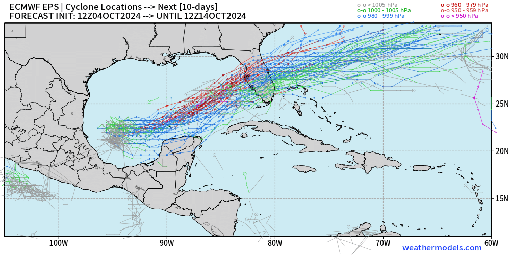
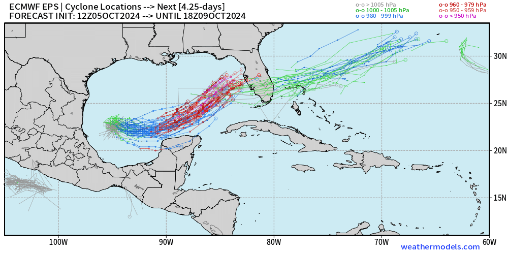
Big signal from the 12z EPS members...