andyhb
-
Posts
20,454 -
Joined
-
Last visited
Content Type
Profiles
Blogs
Forums
American Weather
Media Demo
Store
Gallery
Everything posted by andyhb
-
Yeah the western part is definitely weak and still feeling some of the dry air.
-
Warm waters don't mean much until it gets rid of the dry air.
-
But without any context as to what the picture is showing (and the cutting off of the color bars), how is someone supposed to answer that question?
-
This picture tells me literally nothing.
-
This map may look substantially different in a few days. The projected track of Helene is into an area that's generally devoid of intense hurricane strikes.
-
Would be dependent on it mixing out dry air and completing its inner core by tonight/early tomorrow.
-
Considering the storm makes landfall at sub 920 mb and is moving quite fast, this would be the worst case scenario for GA. Think Michael but larger.
-
New HWRF is, for lack of a better term, a complete disaster. Makes landfall as a very large/high end Cat 4, takes it over Tallahassee, and then remains sub-960 mb into N GA with gusts that would probably exceed 90 mph over a large area (along with the flooding in the Appalachians).
-
Why are you still up to this cringe BS?
-
One of the best places in North America is burning to the ground as we speak (Jasper AB).
-

2024 Short/Medium Range Severe Weather Discussion
andyhb replied to Chicago Storm's topic in Lakes/Ohio Valley
Tornado moving directly into downtown Chicago near 290 right now, jesus christ. -
2024 Short/Medium Range Severe Weather Discussion
andyhb replied to Chicago Storm's topic in Lakes/Ohio Valley
Peoria is going to get hammered. -
2024 Short/Medium Range Severe Weather Discussion
andyhb replied to Chicago Storm's topic in Lakes/Ohio Valley
Outbounds are maxed out for the segment near Kewanee, not dissimilar from the Cedar Rapids MCV in the 8/10 derecho. -
Tomorrow's threat is legit in Upstate NY and Central PA, Beryl has already been a prolific tornado producer.
-
Great catch for a TC chase. The dry air aloft that interfered with Beryl's redevelopment in the Gulf definitely helped these things yesterday and the hodographs were quite favorable for long lived/cyclic supercells.
-
That makes me seasick just watching it, yikes.
-
Nevermind yes, looked like it stayed barely off the coast. Otherwise it probably would've been another Gilbert for them.
-
Extensive, high end wind damage on Carriacou. Many, many structures with roofs torn off and a good number that are completely destroyed, near complete vegetation loss.
-
That's just a straight buzzsaw.
-
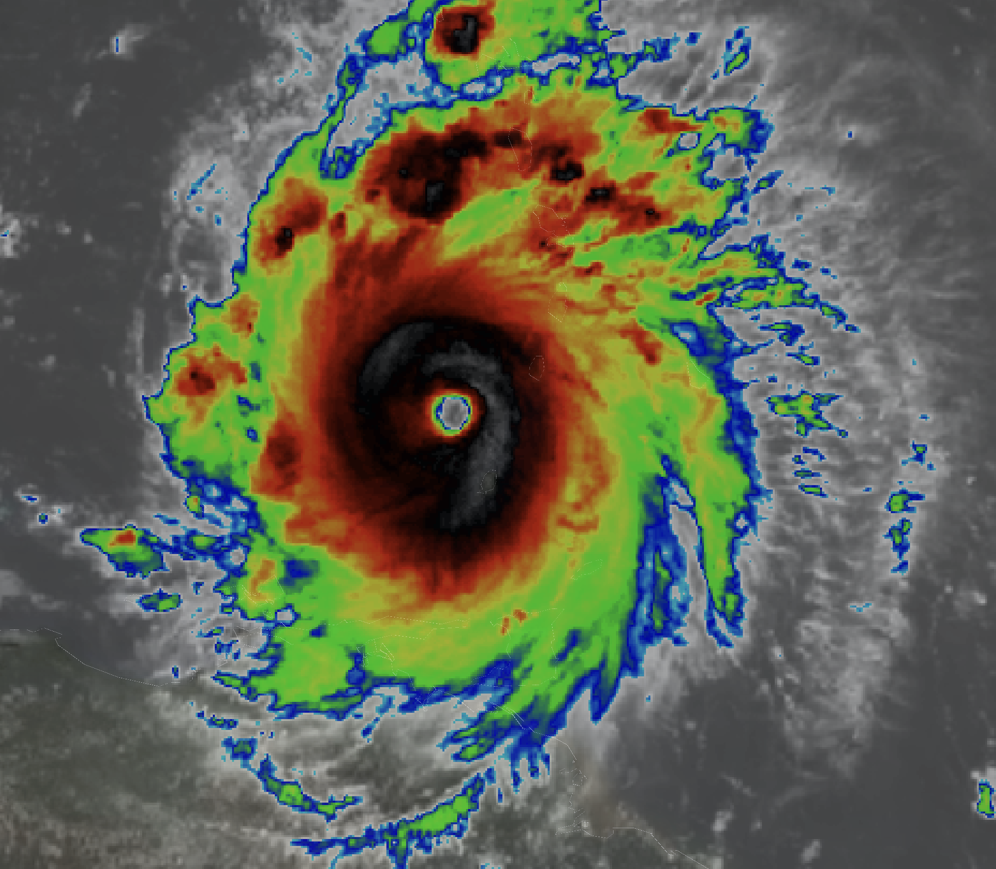
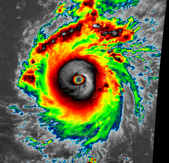
Definitely making a run at a 5 right now.

-
150 mph at landfall, absolutely unreal.
-
Carriacou and Union Island are getting absolutely smashed right now. For reference, this is perhaps the most powerful hurricane to ever affect this portion of the Windward Islands. The catastrophic 1780 hurricane was likely more intense, but it passed further north with a direct hit on Barbados. Only Ivan and (less so) Janet are comparisons in the modern era. Utterly insane for this to be happening on July 1st.
-
That’s a Cat 4, FL winds of 126 kts and a less suspect SFMR of 124 kts. Easily should be enough to push it to 115 kts. Unprecedented.