andyhb
-
Posts
20,454 -
Joined
-
Last visited
Content Type
Profiles
Blogs
Forums
American Weather
Media Demo
Store
Gallery
Everything posted by andyhb
-
Tuesday also looks like a potentially significant severe event over AR and MO primarily depending on what occurs overnight Monday into Tuesday morning. Very strong flow with the ejecting wave and a substantial dryslot aloft to aid in renewed destabilization. Additionally there appears to be a diffuse Pacific front/dryline pushing east.
-
There isn't really much blocking in the northern latitudes right now.

-
Not going to to get much more into specifics on this one right now, but the trough ejection on multiple models here looks favorable for a higher end threat, especially in Oklahoma.
-
Supercell on that boundary in the Austin area could be bad news, especially with rush hour on I-35.
-

4/1-4/2 severe threat (southern portion of subforum)
andyhb replied to largetornado's topic in Lakes/Ohio Valley
Looks like a tornado approaching West Union OH with the same storm. -
4/1-4/2 severe threat (southern portion of subforum)
andyhb replied to largetornado's topic in Lakes/Ohio Valley
Strong tornado in progress in E TN NE of Wartburg right now. Edit: also a tornado in progress NE of Louisville. -
4/1-4/2 severe threat (southern portion of subforum)
andyhb replied to largetornado's topic in Lakes/Ohio Valley
Significant tornado in progress in central WV. Also its 71/64 with a south wind at Covington KY (Cincinnati metro) rn. Anyone calling bust/counting out at least SW OH for later needs to take a step back. -
4/1-4/2 severe threat (southern portion of subforum)
andyhb replied to largetornado's topic in Lakes/Ohio Valley
A lot of convection over OK and MO that is going to need to be worked out before we figure what tomorrow's ceiling is. I will say that this is on the "more inhibitive" side in terms of convective coverage from what I've seen in past events. -
4/1-4/2 severe threat (southern portion of subforum)
andyhb replied to largetornado's topic in Lakes/Ohio Valley
Outbreak potential with intense/long-tracked tornadoes mentioned in that outlook. -
4/1-4/2 severe threat (southern portion of subforum)
andyhb replied to largetornado's topic in Lakes/Ohio Valley
12z HRRR was knocking on the door of a high risk for IN/OH. -
4/1-4/2 severe threat (southern portion of subforum)
andyhb replied to largetornado's topic in Lakes/Ohio Valley
Yeah there's definitely something eerie about a potentially significant severe threat one day before the 50th anniversary of, hands down, the worst tornado outbreak to ever affect the Ohio Valley. -
2024 Short/Medium Range Severe Weather Discussion
andyhb replied to Chicago Storm's topic in Lakes/Ohio Valley
Probably should consider a separate thread for this one soon. The 12z NAM also brought back a significant threat after losing it at 00z. -
2024 Short/Medium Range Severe Weather Discussion
andyhb replied to Chicago Storm's topic in Lakes/Ohio Valley
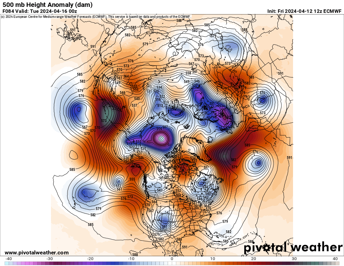
Yes the 18z NAM is absolutely nasty on Tuesday. Granted, that probably won't hold, although its 500 mb setup isn't much different than the other models. The low levels will make or break this along with prior convection from Monday. -
2024 Short/Medium Range Severe Weather Discussion
andyhb replied to Chicago Storm's topic in Lakes/Ohio Valley
Well yeah, you used to live in Florida. -
2024 Short/Medium Range Severe Weather Discussion
andyhb replied to Chicago Storm's topic in Lakes/Ohio Valley
Tuesday looks potentially volatile in the OV on the 12z GFS and Euro. 40-50 kt SW/WSW LLJ with a potent vort ejecting out of the Plains positive tilt trough. Moisture looks like a non-issue, the primary fly in the ointment looks to be the degree of veering in the surface winds, which will also be tied to the timing of the ejecting wave/potential phasing with the northern stream. -
2024 Short/Medium Range Severe Weather Discussion
andyhb replied to Chicago Storm's topic in Lakes/Ohio Valley
7 tornadoes confirmed thus far in the ILN CWA. -
2024 Short/Medium Range Severe Weather Discussion
andyhb replied to Chicago Storm's topic in Lakes/Ohio Valley
Now high end EF3. Have some suspicion that there are a few points that may be consideration for EF4. The Taco Bell and the church that were both completely destroyed in particular. -
2024 Short/Medium Range Severe Weather Discussion
andyhb replied to Chicago Storm's topic in Lakes/Ohio Valley
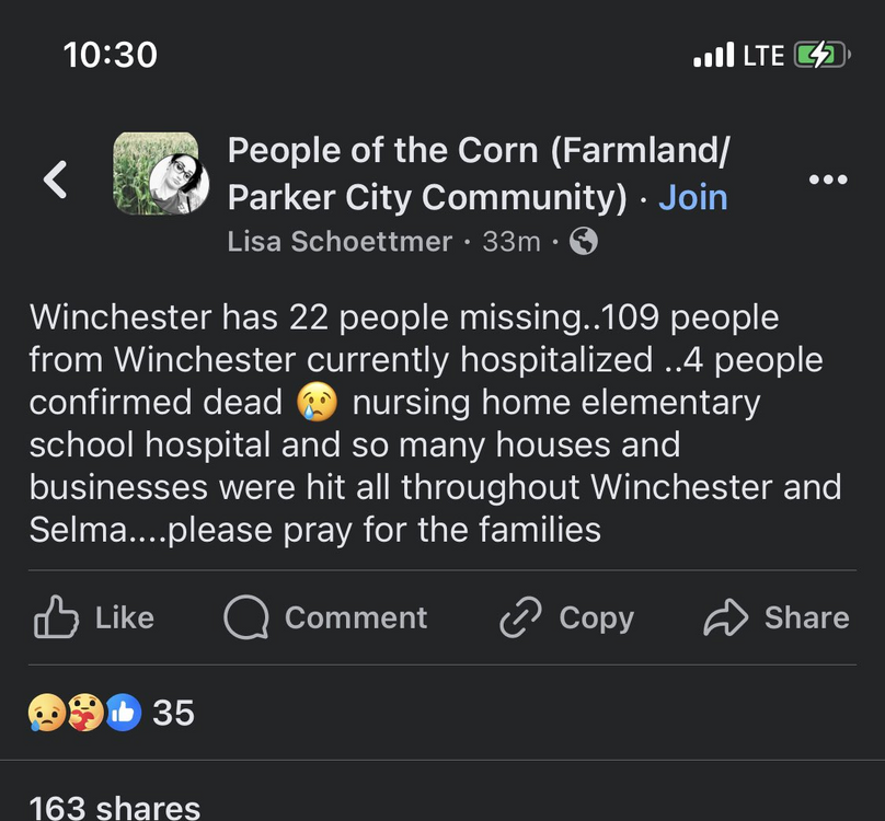
I'm not sure on the number of confirmed dead. The last more official statement I saw was 3 dead with the likelihood to rise. Also I believe the Lakeview tornado has been upgraded to EF3 from the earlier EF2 PNS in Orchard Island. -
2024 Short/Medium Range Severe Weather Discussion
andyhb replied to Chicago Storm's topic in Lakes/Ohio Valley
The fatalities in Winchester were redacted later. I think someone got "casualties" lost in translation or something of the sort. -
2024 Short/Medium Range Severe Weather Discussion
andyhb replied to Chicago Storm's topic in Lakes/Ohio Valley
https://www.whio.com/news/local/injuries-storm-related-damage-reported-mercer-county/ZE7JIPWZNNAFVKOUSCV3VTT5N4/ Fatalities confirmed in Logan Co. OH from the Wapakoneta/Lakeview tornado. -
2024 Short/Medium Range Severe Weather Discussion
andyhb replied to Chicago Storm's topic in Lakes/Ohio Valley
-
2024 Short/Medium Range Severe Weather Discussion
andyhb replied to Chicago Storm's topic in Lakes/Ohio Valley
-
2024 Short/Medium Range Severe Weather Discussion
andyhb replied to Chicago Storm's topic in Lakes/Ohio Valley
Need a separate thread for this. -
2024 Short/Medium Range Severe Weather Discussion
andyhb replied to Chicago Storm's topic in Lakes/Ohio Valley
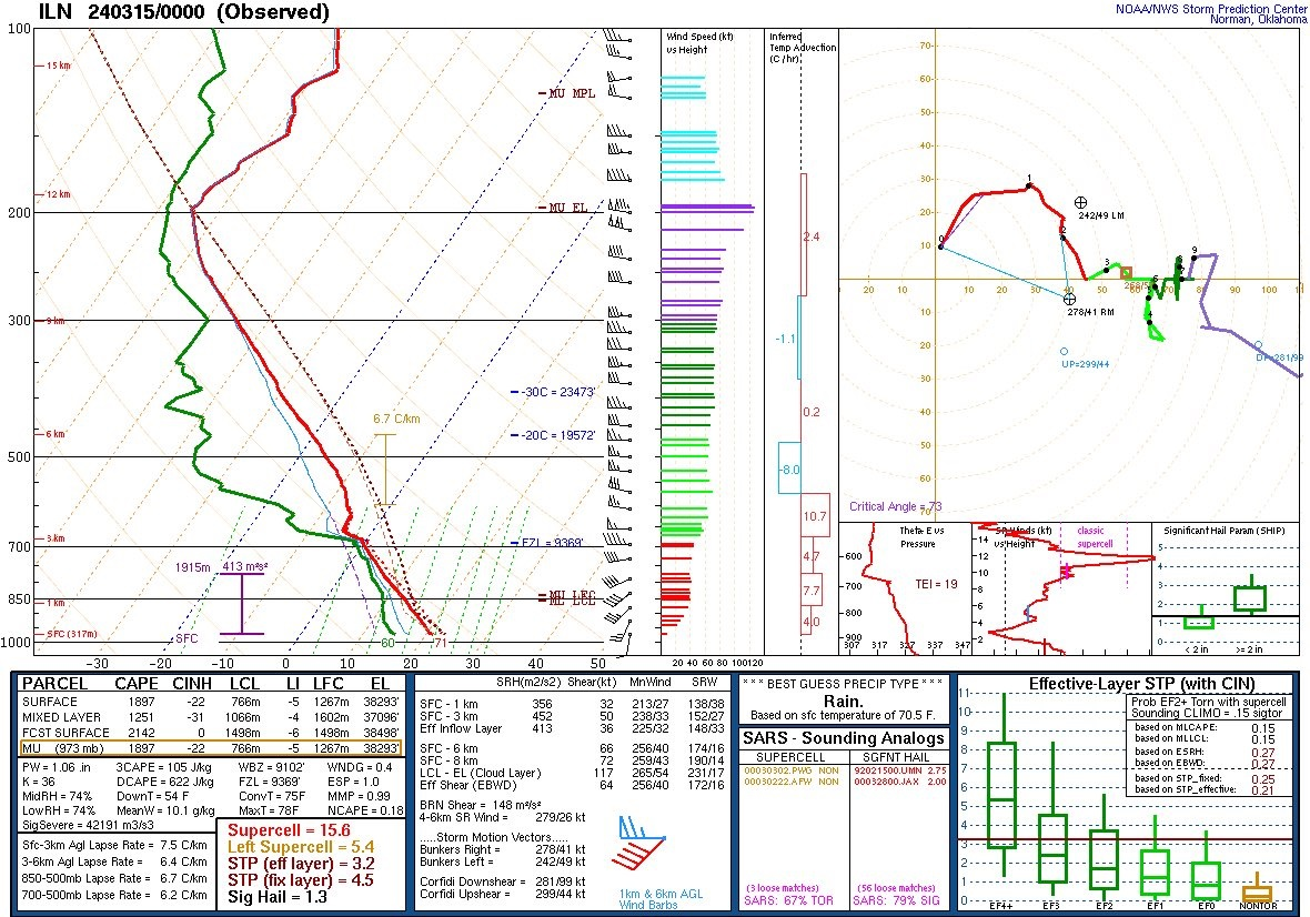
00z ILN sounding is very favorable for strong tornadoes.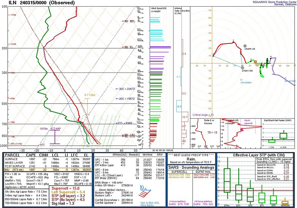
-
2024 Short/Medium Range Severe Weather Discussion
andyhb replied to Chicago Storm's topic in Lakes/Ohio Valley
Tornado in Lakeview OH earlier.