andyhb
-
Posts
20,454 -
Joined
-
Last visited
Content Type
Profiles
Blogs
Forums
American Weather
Media Demo
Store
Gallery
Everything posted by andyhb
-

Winter 2023/24 Medium/Long Range Discussion
andyhb replied to Chicago Storm's topic in Lakes/Ohio Valley
Basically what it comes down to is that 1/11-13 shortwave needs to be the dominant one in the wave train for this potential with this to take off. In other words, it needs to be slower/amplify more in the west prior to ejecting into the Plains. -
Winter 2023/24 Medium/Long Range Discussion
andyhb replied to Chicago Storm's topic in Lakes/Ohio Valley
If we see the ensembles start to emphasize that in-between shortwave more in the next few runs, then we’ll know it might be curtains for the high end. Going to be difficult to get 3 consecutive waves to amplify significantly regardless of your background regime. Edit: EPS mean still looks rather promising.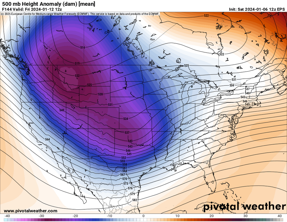
-
Winter 2023/24 Medium/Long Range Discussion
andyhb replied to Chicago Storm's topic in Lakes/Ohio Valley
The wave in between the first system and the one we’ve been tracking is now too deep/amplified as well. There’s no moisture leftover for that one to be the big storm. Storms with so many moving parts like this tend to be very iffy. -
Winter 2023/24 Medium/Long Range Discussion
andyhb replied to Chicago Storm's topic in Lakes/Ohio Valley
12z Euro is a total bust because the shortwave doesn’t amplify and just slides east. Number one concern with this one. -
Winter 2023/24 Medium/Long Range Discussion
andyhb replied to Chicago Storm's topic in Lakes/Ohio Valley
Thanks for saying all of this more eloquently than I can. Yeah the difference in the ensemble means (particularly the GEFS from the GEPS and EPS) in handling the PV interaction makes me think that this main wave needs to amplify in the west initially to avoid a) sliding east/south and turning into a nor’easter and b) getting suppressed to the point of a lesser event. CMC operational showed the former. If the timing is right though, the Euro, GFS, and what would be the UK just beyond range are the types of potential you look for once a decade essentially. -
Yeah that second storm has true high end potential if it evolves anything like the 00z GFS or Euro. Both of those runs are historic storms for large swaths of real estate.
-
Winter 2023/24 Medium/Long Range Discussion
andyhb replied to Chicago Storm's topic in Lakes/Ohio Valley
Pretty similar idea on the 00z GFS and Euro, 6 hours apart. Some truly high end dynamics at play here if this is the general idea we see in a few days, but there are a number of caveats of course. Timing and the amplitude of that main shortwave are the main ones.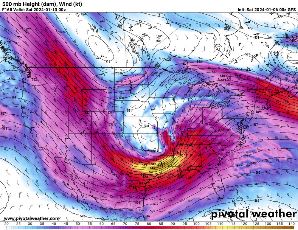

-
Winter 2023/24 Medium/Long Range Discussion
andyhb replied to Chicago Storm's topic in Lakes/Ohio Valley
UK about to uncork a monster as well at the end of the run. If that wave decides to dig a bit in the southwest and gets some help from the northwest via phasing or just as a kicker to help it swing out negatively tilted, the sky is the limit with the cold air waiting. -
Winter 2023/24 Medium/Long Range Discussion
andyhb replied to Chicago Storm's topic in Lakes/Ohio Valley
That would be rivaling the Blizzard of 1978 for the most severe on record in the Midwest. I say that with an entirely straight face. -
Winter 2023/24 Medium/Long Range Discussion
andyhb replied to Chicago Storm's topic in Lakes/Ohio Valley
...are you kidding me? -
Winter 2023/24 Medium/Long Range Discussion
andyhb replied to Chicago Storm's topic in Lakes/Ohio Valley
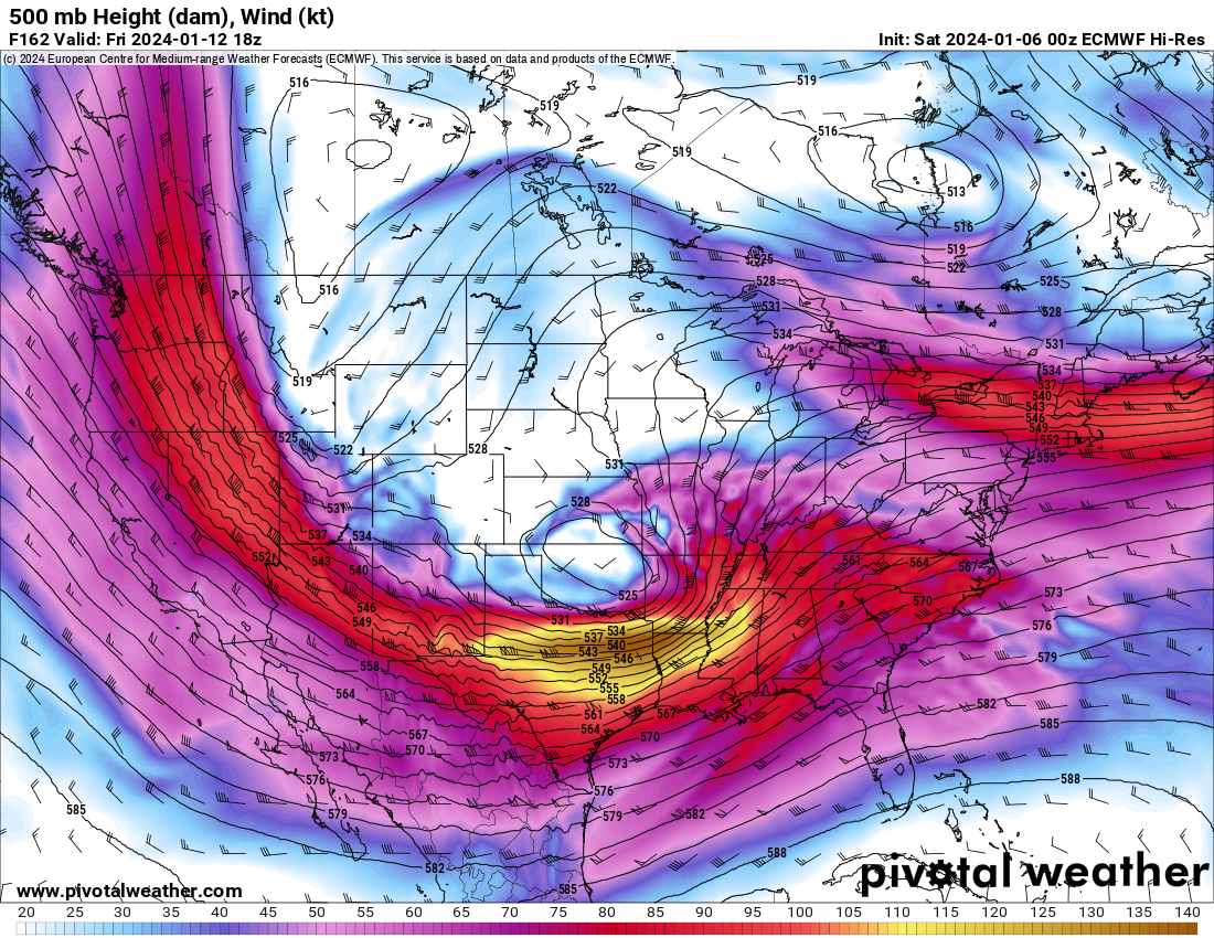
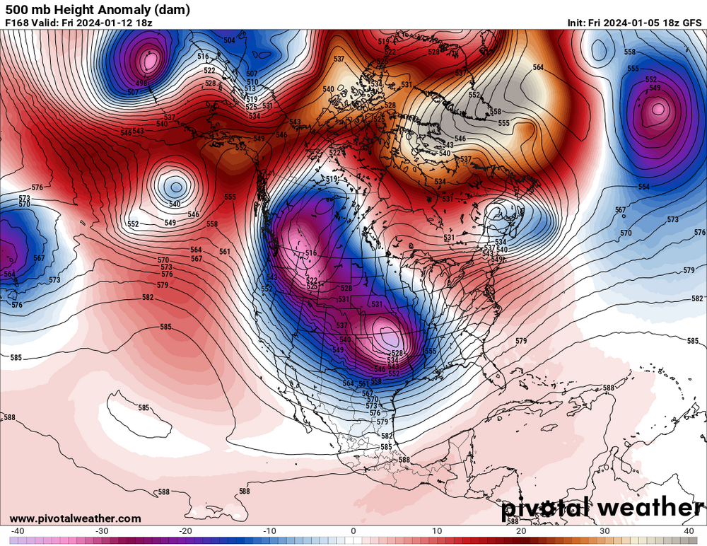
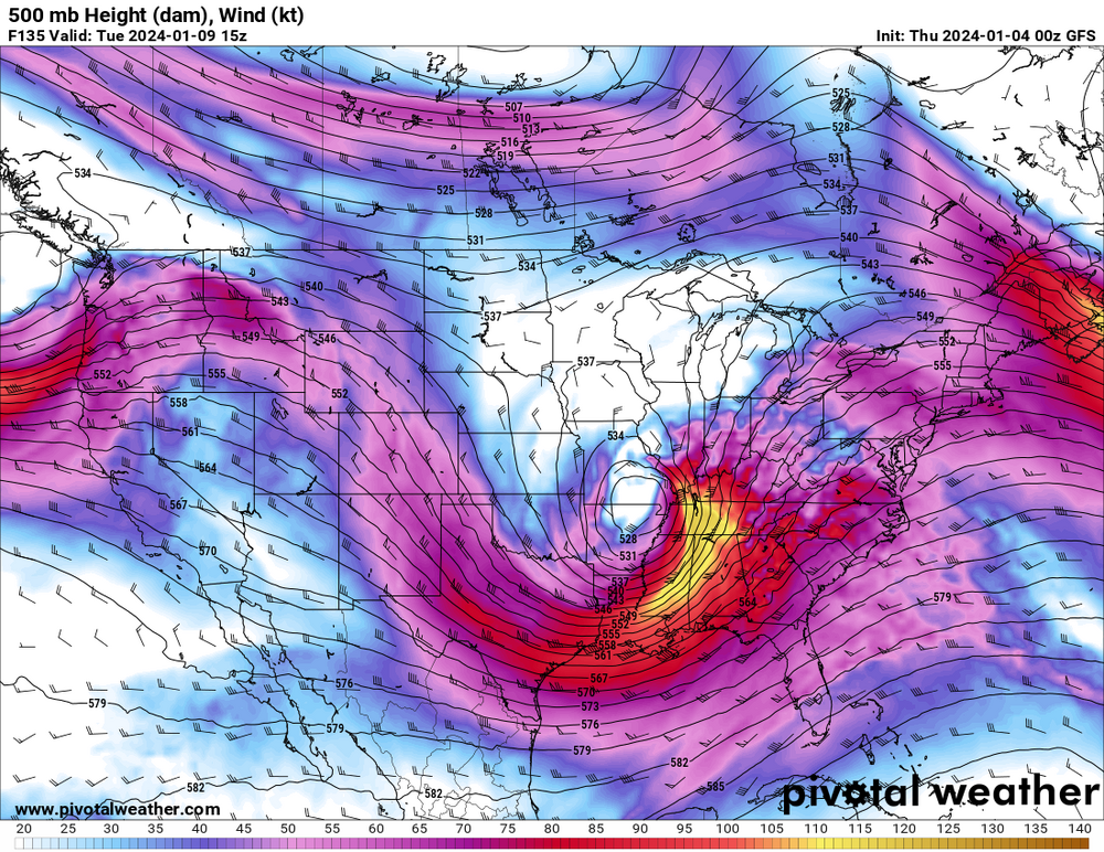
The 500 mb trough with that is... a spectacle, let's just say that.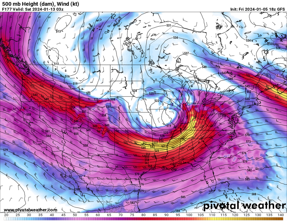
-
Winter 2023/24 Medium/Long Range Discussion
andyhb replied to Chicago Storm's topic in Lakes/Ohio Valley
@cyclone77 you still with us after that run? -
Winter 2023/24 Medium/Long Range Discussion
andyhb replied to Chicago Storm's topic in Lakes/Ohio Valley
Meanwhile the 12z Euro absolutely hammers the I-44 corridor with a historic winter storm next week. -
12z Euro is quite simply a monster of a storm for the I-44 corridor next week. The overall pattern with an Arctic air mass dumping into the NW and a very potent jet/baroclinic zone seems supportive of something bigger for this region in that timeframe, although exact timing of shortwave amplification will dictate when and how high the ceiling might be.
-
Winter 2023/24 Medium/Long Range Discussion
andyhb replied to Chicago Storm's topic in Lakes/Ohio Valley
rdy 2 b glaciated -
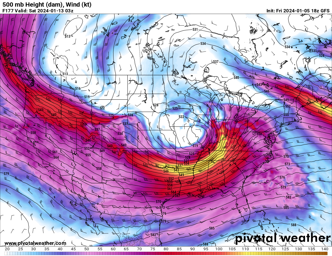
00z GFS manages to hammer St. Louis, Chicago, Detroit, Toronto, and Montreal. True share the wealth track. That is just an incredibly impressive upper low for that far south. Sure, it could use more cold air, but dynamic cooling will no doubt come into play with such a potent setup aloft.
-
EPS mean is also quite impressive considering the somewhat iffy operational run. How wound up the upper low is when it begins progressing poleward will be key in determining the extent of precip and also the warm nose. I’d keep an eye on any shifts towards a more open wave/less occluded cyclone especially early in the storm’s evolution across the Plains and MS Valley.
-
Substantial uptick in snowfall/QPF for most of the Lakes/Midwest on the 12z GEFS mean vs. the 06z.
-
Winter 2023/24 Medium/Long Range Discussion
andyhb replied to Chicago Storm's topic in Lakes/Ohio Valley
It is possible, albeit I’d put the probability of such an outcome on the lower side given an occlusion that far south is a relative rarity. -
Winter 2023/24 Medium/Long Range Discussion
andyhb replied to Chicago Storm's topic in Lakes/Ohio Valley
Low occludes too early on the 18z GFS. -
Jan Medium/Long Range Disco: Winter is coming
andyhb replied to stormtracker's topic in Mid Atlantic
I don’t check in here all that often, but I’ll summarize the last few days of model runs for January across most of the CONUS in a couple of words. Switch. Flipped. -
Winter 2023/24 Medium/Long Range Discussion
andyhb replied to Chicago Storm's topic in Lakes/Ohio Valley
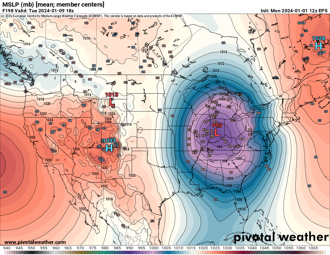
Ensemble means continue to indicate the potential for a higher end event late this weekend into early next week. Pretty expansive area of significant snowfall on the means, and a solid chunk of the members really bomb the surface low out into the 970s. Would suggest fairly widespread blizzard conditions are possible. Looks to be a potential coast to coast storm as well and should certainly help the snowpack out west. I do like how the cold air is there but not overwhelming, which would suggest less potential for the surface low to get suppressed by excess high pressure in its developmental stages.
-
Winter 2023/24 Medium/Long Range Discussion
andyhb replied to Chicago Storm's topic in Lakes/Ohio Valley
#rdy2bburied -
Winter 2023/24 Medium/Long Range Discussion
andyhb replied to Chicago Storm's topic in Lakes/Ohio Valley
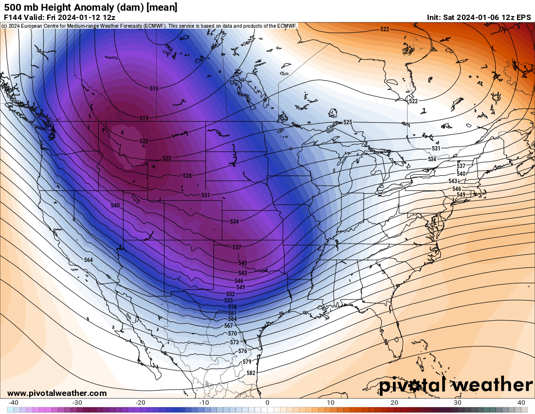
Impressive EPS mean for that far out.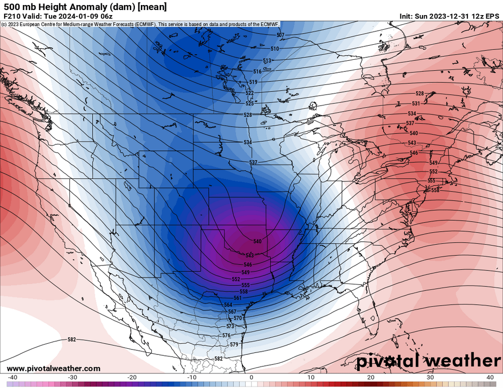
-
Winter 2023/24 Medium/Long Range Discussion
andyhb replied to Chicago Storm's topic in Lakes/Ohio Valley
That storm on the Euro/GFS/ensembles in the second week of January is a monster. A bit of a shame that moisture is cut off by the preceding system about 36-48 hours prior, but the ensembles are pretty locked it for high impact potential across a pretty large expanse of real estate. One may be concerned about the degree of suppression if all of the cold becomes involved at once, the STJ dominates, and/or the surface reflection isn’t as strong initially.