Radtechwxman
-
Posts
2,481 -
Joined
-
Last visited
Content Type
Profiles
Blogs
Forums
American Weather
Media Demo
Store
Gallery
Everything posted by Radtechwxman
-
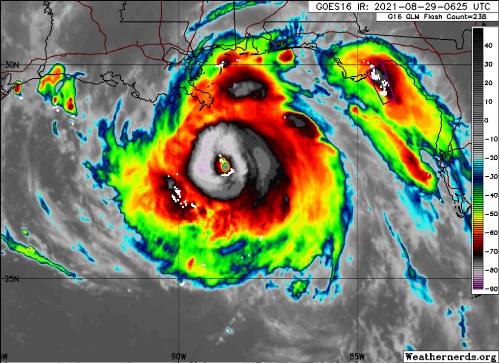
What an incredible few hours of strengthening. It has exceeded what it did all day in a few hours.
-
Huge uptick in eyewall lightning now. Ida is bombing. The scenario we all feared. My earlier call of this not hitting 130 was very wrong. Just took a long time for Ida to organize
-
With the high octane fuel of the Loop Current, I'm surprised we aren't seeing a big uptick of eyewall lightning with pressures quickly falling and convection increasing.
-
IR presentation definitely improving but can't really say for sure it's bombing till we get aircraft in there to get accurate wind readings and new pressure info
-
I'm starting to get skeptical of this hitting 130 before landfall. Ida really running out of time. If it doesn't really bombs away in next 6-10hrs I'm thinking a low to mid cat 3 more likely. Regardless of whether it's a cat 3 or 4, surge and rain will still bring a lot of destruction along with the 110+ gusts.
-
Seems like Ida might be one of those hurricanes whose wind field might expand more than winds increasing. Pressure been dropping all day with increasing wind field but strength of winds been slower to rise.
-
Which is odd because wasn't dry air supposed to be NIL? NHC was always talking about a very moist environment
-
Can't really fudge numbers. That's unethical if it isn't true. Hunters hunters will be in soon and can give more accurate information than Dvorak analysis
-
105mph 976mb new advisory. They said RI underway
-
Yeah I'm a bit perplexed given the environment it's in. I honestly thought it would be exploding right now. Clearly something still holding it back.
-
Definitely was expecting to wake up to a much stronger cane. IR presentation is improving though.
-
As NHC predicted, Cuba had little impact on Ida. Curious to see how soon we will see RI start again. Would think it would start later tonight but if not then for sure all day tomorrow. Very nervous to see what we wake up to tomorrow in the Gulf.
-
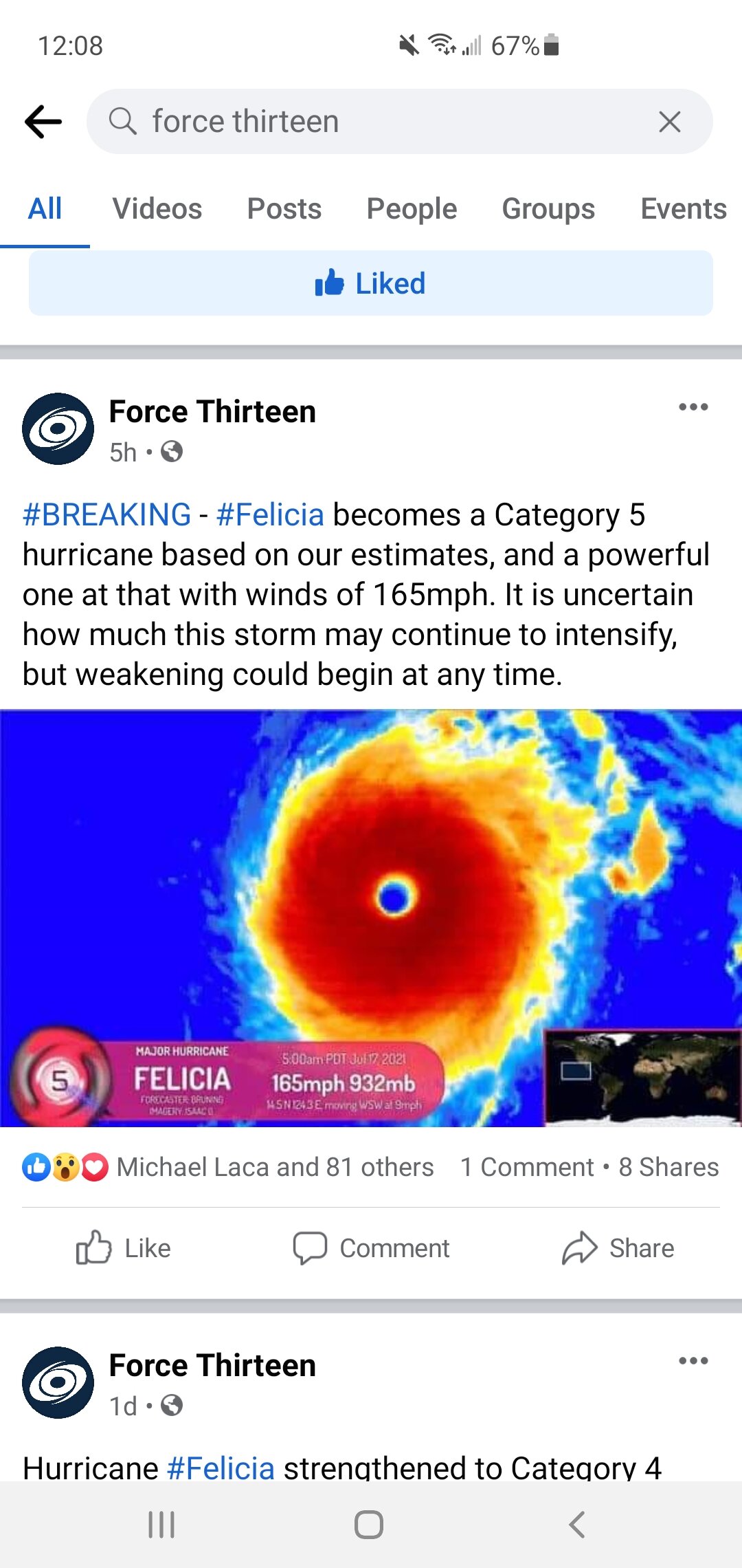
No. There is certainly nothing official with regards to forecast discussion or analysis that suggests this is a Category 5. TAFB Dvorak analysis hit T6.5/127 kts per discussion and ADT numbers are about 10 kts lower. Felicia has already maxed out for an annular-type TC within the current thermodynamic environment. It would need to drop a bit more latitude and reach warmer SSTs to get any stronger. Even with cooler upper tropospheric temperatures, Felicia's core is riding a 26.5 to 27°C isotherm. Its eyewall has probably maxed out potential intensity at its current westward vector of motion. I agree with you. Someone needs to call out this page for spreading false information.

-
I follow a page called Force Thirteen on FB and they claimed this hit cat 5 status 4hrs ago. Anyone know if that's true?
-
I can't believe this stayed a hurricane. Probably the ugliest "hurricane" on record.
-
Structure looked better on satellite and radar earlier when it was tropical storm. Haha. Had a nice northern eyewall like feature on radar north of Key West. Now radar presentation is choppy and satellite looks more lopsided compared to earlier.
-
Definitely seems to be the trend. Models look great then it fizzles out and appears a week later. The eastern troughing is a killer this season and now this cf wiping out moisture. Tomorrow would probably be a good tornado day otherwise. At least getting into mid to late May we are more likely to have better moisture. Pattern seems to really try to break down after mid May. Hoping it can pull a 2013 and get real active in a hurry last few weeks of May or at least a week. I have a break from school May 14-June 1 so would love to get a chase or two in before I go back.
-

Central/Western Medium-Long Range Discussion
Radtechwxman replied to andyhb's topic in Central/Western States
We just can't shake these ne troughs this year. Really creating a lot of downstream blocking. Long range gfs digs a major trough into the ne and a ridge builds in the central US as another trough digs into west coast. This omega block would definitely significantly lower severe wx chances. Just can't seem to shake eastern troughing this year. I only have between May 14 and June 1 to chase and I'm not feeling very optimistic right now. -
Severe Weather April 27-28th 2021
Radtechwxman replied to cheese007's topic in Central/Western States
Definitely disappointing to see a trough get sheared out and cutoff during peak season. Crazy how bad this has trended from days ago. Went from a strong negative tilt to a strung out positive tilt that cuts off an upper low. I really hope May can turn things around but I must say not liking the look of long range. Obviously that can and will change. Look how much Tues has changed. I'm starting to wonder if this will be another season of failed big setups with days that look marginal overperforming. I mean that's not bad as long as we get some nice tornadoes like the other day. -
Central/Western Medium-Long Range Discussion
Radtechwxman replied to andyhb's topic in Central/Western States
Not digging the look of upper air pattern in medium to long range. The trough next week has really trended to a more sheared out positive tilt that eventually cuts off an upper low. Long range gfs builds in a big ridge west and trough east that eventually turns into an omega block. Euro doesn't go out as far as gfs but it also looked to be building a pretty substantial ridge. Obviously this can and will change as models do but definitely discouraging to see. -
Yeah early to mid April definitely looks to be pretty stagnant. Hopefully we see a pattern shift mid to late April. Just always concerning when you see these patterns in peak tornado months. Getting flashbacks of last year.
-
Man if you're wanting an active severe wx pattern for April, GFS is not the outcome you want to see. Forms a massive omega block after the first week of April and persists well into mid April. Euro didn't look as blocky. Teleconnections support a more active pattern so hopefully GFS is out to lunch.
-
Is there a rating yet on the Greensboro tornado that went through Brent and Centreville?
-
Yeah I think there was one death with that tornado. That outbreak definitely overperformed with several intense tornadoes esp at dusk or after dark. I was thinking the same thing. I saw a few pictures where houses were leveled and partially swept off foundation. Those were nicer homes to so guessing it would be properly anchored.
-
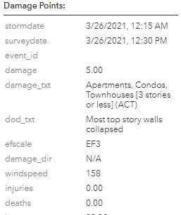
Looks like preliminary high end EF3 for Newnan