

Radtechwxman
-
Posts
2,481 -
Joined
-
Last visited
Content Type
Profiles
Blogs
Forums
American Weather
Media Demo
Store
Gallery
Everything posted by Radtechwxman
-
Nam's/rap being generous with this wave sun night into Mon. Right now ILX isn't showing accumulating snow in my grids with only 50% pops. Definitely think that needs to be bumped up. Hrrr looks much drier but it also did abysmal with this current wave.
-

Feb 12-14th V-Day Weekend Potential Stuff
Radtechwxman replied to Chicago Storm's topic in Lakes/Ohio Valley
Ended up lucking out with a nice 1.5-2in of arctic fluff. Looks like another band may push through racing east from the MS River. -
Feb 17-19th Potential Of Potential
Radtechwxman replied to Chicago Storm's topic in Lakes/Ohio Valley
With these storms ejecting out pretty south how likely is it that this follows the southern fringe of the snow pack that will be left from storm #1? Gfs and gem definitely more on board for a more northerly ejection but euro and ukmet seem to support my idea of a much more suppressed storm albeit weaker. -
You and me both man. Is it tornado season yet?
-
Feb 12-14th V-Day Weekend Potential Stuff
Radtechwxman replied to Chicago Storm's topic in Lakes/Ohio Valley
Sounds about right. Dead on arrival. I give up on this winter. Lol -
Feb 12-14th V-Day Weekend Potential Stuff
Radtechwxman replied to Chicago Storm's topic in Lakes/Ohio Valley
Forever living on the edge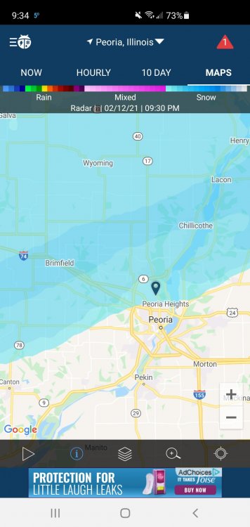
-
Feb 12-14th V-Day Weekend Potential Stuff
Radtechwxman replied to Chicago Storm's topic in Lakes/Ohio Valley
Nice band stalled a few miles north of me. This is not my winter. Lol. Hoping it can build south later. -
Feb 12-14th V-Day Weekend Potential Stuff
Radtechwxman replied to Chicago Storm's topic in Lakes/Ohio Valley
Hrrr seems very lost today. Rap seems to have better handle on current trends -
Sounds fitting for this winter. Curious if we will see other models trend that direction. Nam and gem still showing a decent precip shield into a good chunk of IL.
-
Whelp euro took a step towards GFS for next week. Barely brings the precip shield into IL except the far east. Curious if globals are underestimating precip on nw side. Higher res like nam suggests more snow pretty far nw. Not holding my breath though. Trend this winter seems to be downward as we get closer.
-
Feb 12-14th V-Day Weekend Potential Stuff
Radtechwxman replied to Chicago Storm's topic in Lakes/Ohio Valley
Hrrr seems to be latched onto the idea of a band forming to our ne and backbuilding sw into us tonight. -
Feb 12-14th V-Day Weekend Potential Stuff
Radtechwxman replied to Chicago Storm's topic in Lakes/Ohio Valley
I could see this all ending up north of us. Tricky setup for models. Seem splotchy with the snow. Frontogenic band will likely be north. -
Long range of nam looks decent. Euro still shows potential. Gfs had a bit more here than it did before. Rgem looked good. Is ukmet reliable? I'm not familiar with it's accuracy
-
Feb 12-14th V-Day Weekend Potential Stuff
Radtechwxman replied to Chicago Storm's topic in Lakes/Ohio Valley
Crazy how sharp the cut offs have been in our county. Esp near I74 -
Feb 12-14th V-Day Weekend Potential Stuff
Radtechwxman replied to Chicago Storm's topic in Lakes/Ohio Valley
Well this has trended to a real dry prune. How depressing. I have barely squeaked out anything from this cold active pattern. Cue Taps with the trumpet. -
GFS seems a bit lost per usual. Definitely sad when Oklahoma is going to have a better winter than most of IL. Forecasting 8-12in in their watch there. Shoot at this point I would kill for high end advisory or low end warning amounts. Definitely will hurt if it's a near miss like that. Like either slam me or go far away. Lol
-
I'm sure it will end up trending completely to GFS because why not. But holding hope we can get some decent snows in the deformation band of the upper level system since the sfc system is way south
-
HAHA. Now a better looking storm behind this. I feel like our big storm forever keeps getting pushed out. It's the Neverending Story of meteorology.
-
This going to be another promising long range storm that becomes a polished turd?
-
Feb 12-14th V-Day Weekend Potential Stuff
Radtechwxman replied to Chicago Storm's topic in Lakes/Ohio Valley
I think GFS is underdoing the precip. Nam seems to be more in line with what I think will happen. But we shall see -
Definitely an interesting system. Really won't know till we get closer esp if something like Euro pans out with the upper low driving snow up here and a very far south sfc system almost like a secondary system spreading a lot of precip albeit a warmer scenario for the Ohio Valley. 18z gfs breaking my heart with a near miss. Come on team euro. Lol
-
Same here. It's been some pixie dust a while. That heaviest band sandwiched between us both. Probably will see 2-3in totals in that. Think an inch at best here if that.
-
Idk why our local weather was saying 1-3in. We will be lucky to see an inch. Heaviest band setting up south which is what hi res suggested but looks like we could see pixie dust to light snow up here north of the main band.
-
Feb 12-14th V-Day Weekend Potential Stuff
Radtechwxman replied to Chicago Storm's topic in Lakes/Ohio Valley
You're not wrong there but it's been extra bad this winter and another sharp cut off always occurs by I74 which I practically sit on. -
Same here. Depends on how far south the HP digs. Euro doesn't dig as much and brings good snows nw into IL. Other models not so much.


