Radtechwxman
-
Posts
2,481 -
Joined
-
Last visited
Content Type
Profiles
Blogs
Forums
American Weather
Media Demo
Store
Gallery
Everything posted by Radtechwxman
-
Yea I thought we would see some nice dry fluffy stuff tonight as the system pulled away but that ended up way north. Feel sorry for you guys down south. Been a snow less winter for you so far.
-
Big plot twist. Dry air was overmodeled on north side but undermodeled on south side. No models really showed snow ending here till after 06z. Had few periods this afternoon of drying but filled back in but now seems last band is pulling out.
-
You always seem to luck out no matter what. Lol. Funny earlier barely had returns over me and it was snowing good and now have a nice band over me and barely anything. Weird system. Ha
-
Looking like between 3-4in of snow here right now. Definitely a drier snow now. Flake size improved somewhat. Radar not looking promising though as best banding is moving out. Hoping we see some fill in later like HRRR suggests.
-
Snowing at a good clip in Peoria but flake size not great. Might limit accumulation potential. Snow overall drier than I expected though. Blowing around. Anyone noticing that massive dry slot developing in MO on radar? Lol. Models don't seem to be grasping that well.
-
Noticing some drying trends on the radar in northern MO. Hoping that will fill back in.
-
New euro definitely came in underwhelming. Happy 2022. Lol
-
Remember when we were like this can only get better as it approaches? 2022 was like hold my beer. Happy new year! Lol
-
Well might be getting ice storm part 2 instead of a snowstorm if nam is correct. Better than cold rain. Curious if the waa will win out against the dense arctic air mass pressing se on Sat. Eventually the cold air will win out but how quick is the million dollar question
-
AccuWeather or as I call them Inaccuweather is an embarrassment to the meteorology community
-
Wouldn't trust any output from rap or hrrr at this range
-
Idk what day it is anymore. Ha. Long hours at the hospital get you delirious. Yes 2 days. I feel like nam is an easy toss 99.9% of the time. I agree with Ricky, retire nam.
-
Well either nam is onto something or smoking something. We shall see soon. Nam solution could verify if a more phased system came to fruition. 12km is a cold rain here and 3km nam is ice storm part 2. This is going to be a long 3 days. But still not going to trust nam 3 days out.
-
Always find it amusing how stubborn models can be in their own solutions and not wanting to converge. Feel like overall most models have seemed closer to GFS with 0z nam being first run of nam with noticeable bump south. Euro being quite stubborn and really wanting to keep much higher totals quite nw of here likely because of stronger warm nose. Definitely not getting excited yet because any bump north on models and it will be a rainer or mix central here.
-
Valid point. Still it's long range. Nice to see a spread the wealth system for many of us. Just hoping not to be on the edge for a change. Plus would be awesome to have back to back NYD storms. Had big ice storm last year and would be awesome to follow it with big snowstorm. Here's to hoping.
-
Well not digging the 18z nam at all. Hello cold rain. Yay. Not. Just need that sfc low to nudge a bit more se and I can cash in. Forever riding the rain/snow line here. Hoping goofus can be right but not getting my hopes up.
-
Honestly thought that run was going to have higher accumulations a bit further south because sfc low seemed a little more south and maybe slightly less amped. But still buried Iowa. Euro not wanting to budge. Curious to see which model caves first. GFS or Euro.
-
Whelp never good when you're living on the se edge of the heavy snow band and models start trending stronger and nw. Lol. Gfs definitely bumped nw on 18z run with sfc low. Still not as strong as euro but maybe a bit more consolidation at the sfc. Still 5 days out and a lot can change but definitely a nail biter here. My gut is saying DVN to LOT will cash in big on this. I was thinking that this may trend se with that arctic baroclinic zone bleeding se and the weakish low but we shall see.
-
GFS came south and Euro came north. Should be be a fun week. Lol. Euro was significantly more amped with sfc low this run which brought it more nw. Gfs still had a decent sfc reflection but nothing like Euro and more strung out and not as consolidated. Curious to see this once it's in nam's range
-
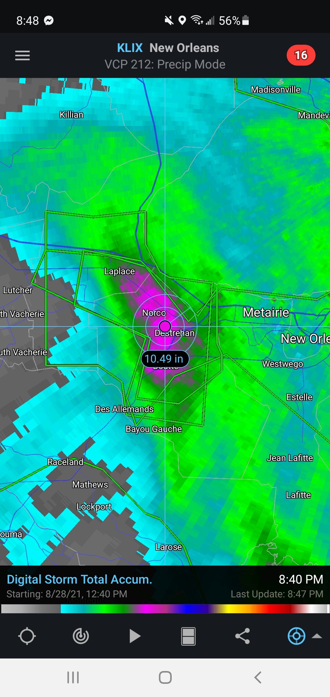
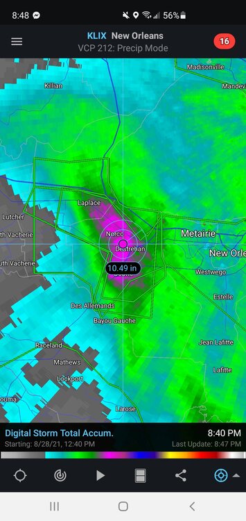
Laplace is in big trough. Eastern eyewall parked over them with insane rainfall rates and now it's starting to retrograde. Easily could see 20in+ of rain
-
Well they're a match made in heaven. I listened to that dudes stream for a solid min and turned it off. Screaming and over exaggerating everything. Just irritates me when people have no regard for their life or others and then expect everyone to save them. Don't wish anything ill on him but just tired of his ways. He's shady.
-
That's CJ Lergner. That dude is a reckless idiot. He would put himself in danger in order to get footage. Most chasers played it safe and stayed away from the vulnerable surge areas but he was way south. He has no regard for other people then expects everyone to bail him out.
-
Man last few radar frames look like Ida is nearly stalled and almost retrograding
-
Think this might achieve cat 5 just before landfall like Michael did?
-
I think Ida may finally be leveling off. Albeit still in warm waters, the OHC near shore is not nearly as impressive as it was in hours ago and absolutely exploded. Regardless, this is going to be catastrophic.