

Radtechwxman
-
Posts
2,481 -
Joined
-
Last visited
Content Type
Profiles
Blogs
Forums
American Weather
Media Demo
Store
Gallery
Everything posted by Radtechwxman
-
 What does everyone think of Wed? Really comes down to timing here in IL. Nam seems to be very fast like gfs and pretty much kills severe threat here because of early timing. Hoping euro is right on timing. This latest run looks a lot more messy as well. Wish I could chase Tues. Hoping for something local Wed here but not feeling optimistic about my chances.
 -
I think Tues and Wed have solid potential. Mon may not have enough moisture yet. Definitely worried about trough timing Wed.
-
This forum is sure absolutely dead for 3 outlooked areas next week in tornado alley.....
-
Yeah I wouldn't trust any gfs solution. Lol
-
It's too bad the storm peaks to our west and dampens east. Would have been a good track for a lot of us to cash in. Hrrr/rap look a bit more robust like nam but not holding my breath. Probably another 1-3in at best.
-
These gfs outputs are laughable. Has a nice band of snow moving in from Iowa and Missouri and then just poof gone. Then it reappears then poof gone again. Makes no sense.
-
Looks like big winner from this will be Des Moines. They been getting crushed by banding. Models didn't do well with this system at all. Pretty much everything had precip here all day with a slight reduction before an uptick again this evening. Pretty much only had one decent wave early this afternoon and that was it then massive dry slot since then. Models hinting at more snow tonight but I'm skeptical. Freezing drizzle now.
-
Lol massive dry slot here
-
This first wave seems like it is going to be a lot further south than models had it. Also the amount of lightning in the wintry precip in MO now is impressive. Wish that was here. I foresee the snow amounts being on the very low end of forecast. I think getting an inch at this point will be optimistic.
-
Curious if this warm nose will get as north as some models suggest. Hrrr bringing it up past I74. ILX was thinking it would mostly impact areas between I70 and I72 but some hi res models are saying otherwise.
-
Had a few rumbles this morning! It was so nice. Let me know spring storms are just around corner.
-
I would be ecstatic for a solid advisory event! No lack of appreciation here! I was saying most guidance has 1-2in which is sub advisory levels. But I will take what I can get! I was mostly saying this system is a letdown compared to last few systems but any winter precip is good to me.
-
GFS still trying to make something of this but everything else looks like trash. Lol
-
I was wondering why it looked that way. I was like is it convective? Lol
-
Wouldn't trust GFS. It did awful with last storm. Can't wait to see what NAM shows. Lol
-
Well right now gfs is pretty much a miss south and euro has a large precip shield that spreads the "wealth" or in this case the "poor" as amounts are pretty anemic.
-
GFS all over the place with this. Euro has been a bit more consistent in snow impacting areas this north. But definitely could see this getting shunted se because of the arctic front. Here's to hoping
-
GOAT thread starter right here. This one has potential for a good thumping on someone. Another big surge of moisture over cold air mass pressing south. Could end up quite south and weak like GFS suggests or a bit stronger and north like Euro suggests.

-
We creating a 2nd thread for part 2 Thurs?
-
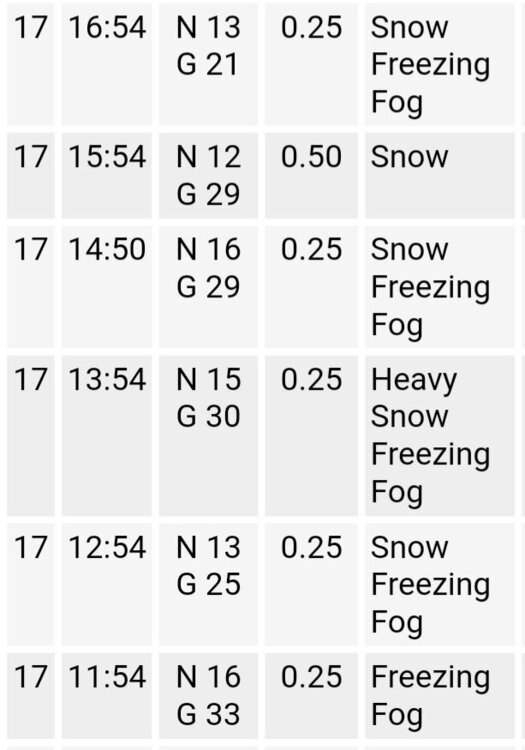
Even though snow totals weren't huge here, it was still a great storm. Had several hours of ripping snow and that incredible death band finale. Sadly was working the whole time so had to periodically look out window. Ha. Looks like 5-6in at my house in North Peoria. As models suggested, heaviest band setup just south of here. If this system was moving slower man this would have been crippling but still a good hit. Peoria airport had 4 consecutive hours of quarter mile visibility which was broke by 1 hr of half mile visibility followed by another hr of quarter mile visibility. Very impressive.
-
Pouring pixie dust in Peoria. Was hoping for some dendritic snow. This could definitely impact totals. Regardless still snowing moderately to heavy at times. Visibility definitely under a half mile in downtown. I will take what I can get.
-
06z nam bumped north slightly with higher totals
-
If only RAP was right. I would be so happy. But HRRR more realistic and in line with other guidance
-
Yet another gift from this POS storm. Lol. PUNT
-
Think maybe that could be part of issue with models shifting south? Or was that mostly because of weaker south sfc low?


