Radtechwxman
-
Posts
2,481 -
Joined
-
Last visited
Content Type
Profiles
Blogs
Forums
American Weather
Media Demo
Store
Gallery
Everything posted by Radtechwxman
-

Jan 19-20: Hoosier is not allowed to start this thread
Radtechwxman replied to mimillman's topic in Lakes/Ohio Valley
Yep not expecting anything. Story of this winter so far. Lol -
Jan 19-20: Hoosier is not allowed to start this thread
Radtechwxman replied to mimillman's topic in Lakes/Ohio Valley
#torch -
Jan 19-20: Hoosier is not allowed to start this thread
Radtechwxman replied to mimillman's topic in Lakes/Ohio Valley
You and me both. Has not been a kind winter thus far. Gfs a little more hopeful but it's gfs. Lol -
Jan 19-20: Hoosier is not allowed to start this thread
Radtechwxman replied to mimillman's topic in Lakes/Ohio Valley
This title is money -
Agreed. 12z gfs looks like only model doing anything meaningful and that isn't saying much.
-
#trash lol
-
0z guidance all still looks pretty spot on except nam being nam which went from 3-5in on 12z and 18z runs and barely 1-2in for 0z run. Lol
-
Pre-Christmas (Dec 21-23rd) Winter Storm Part 2
Radtechwxman replied to Chicago Storm's topic in Lakes/Ohio Valley
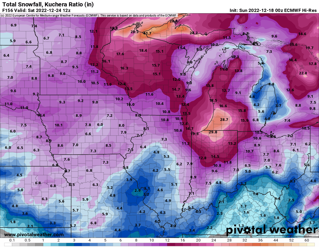
Yeah I looked at what ratios it was using for Kuchera later and was like nope. Normally with this cold it would work but the wind wasn't helping with fracturing the dendrites and I know there was issues with DGZ being misaligned with where forcing was and then had the drying profile with extreme caa behind cf. These winds are no joke today. Consistent 40+ gusts and definitely approaching the 50 mark. -
Pre-Christmas (Dec 21-23rd) Winter Storm Part 2
Radtechwxman replied to Chicago Storm's topic in Lakes/Ohio Valley
Hoping this snow band widens throughout the morning and afternoon as the low deepens and better upper air support rounds trough. Band pretty narrow right now. If it stays how it is now I will probably be looking at 1-2in. Hoping for 3-4in like hi res has been suggesting. Hrrr off it's rocker suggesting 5-6in. -
Pre-Christmas (Dec 21-23rd) Winter Storm Part 2
Radtechwxman replied to Chicago Storm's topic in Lakes/Ohio Valley
Topography out there definitely influences it then it gets in Plains and is like YEET. Lol. Apparently KC area getting a good glaze of ice now. Don't remember that being forecasted. -
Pre-Christmas (Dec 21-23rd) Winter Storm Part 2
Radtechwxman replied to Chicago Storm's topic in Lakes/Ohio Valley
For you yes. Here not so much or I won't see hardly any snow if it moves through too fast -
Pre-Christmas (Dec 21-23rd) Winter Storm Part 2
Radtechwxman replied to Chicago Storm's topic in Lakes/Ohio Valley
Curious if this will mean a quicker hitting snow if cf is faster and stronger caa eating at western edge of snow. Hi res hinted at that in previous runs but 0z seemed to have improved it a bit. -
Pre-Christmas (Dec 21-23rd) Winter Storm Part 2
Radtechwxman replied to Chicago Storm's topic in Lakes/Ohio Valley
Saw someone share this on FB -
Pre-Christmas (Dec 21-23rd) Winter Storm Part 2
Radtechwxman replied to Chicago Storm's topic in Lakes/Ohio Valley
Liking the trend of hi-res guidance tonight. Though waiting for the snow band to really light up down the front like it shows in next 1-2hrs to see if it comes to fruition. -
Pre-Christmas (Dec 21-23rd) Winter Storm
Radtechwxman replied to Chicago Storm's topic in Lakes/Ohio Valley
Lol I called that with nam. I was like watch it be nearly west of IL -
Pre-Christmas (Dec 21-23rd) Winter Storm
Radtechwxman replied to Chicago Storm's topic in Lakes/Ohio Valley
Euro and it's ensembles go east and gfs and it's ensembles went west. Let panic ensue -
Pre-Christmas (Dec 21-23rd) Winter Storm
Radtechwxman replied to Chicago Storm's topic in Lakes/Ohio Valley
Funny I was team euro before but now euro is like my dream crusher model. It's definitely not getting a frisky with the sfc low as quick as gfs -
Pre-Christmas (Dec 21-23rd) Winter Storm
Radtechwxman replied to Chicago Storm's topic in Lakes/Ohio Valley
Gfs wagons west. Lol. Low party for me. Nam will probably track low west of IL  will this be start of permanent nw trends or will we see se corrections as we get closer? I think we will see gfs correct se. But a very amped system would end up more nw. But I think gfs is unrealistic imo. -
Pre-Christmas (Dec 21-23rd) Winter Storm
Radtechwxman replied to Chicago Storm's topic in Lakes/Ohio Valley
Live and die by the GFS. Lol -
Pre-Christmas (Dec 21-23rd) Winter Storm
Radtechwxman replied to Chicago Storm's topic in Lakes/Ohio Valley
Euro solution is definitely more of a downer. Still a good event with high winds and some decent snow here but really miss out on all the wraparound snow as the low occludes too ne of me so totals are significantly less than gfs obviously. I knew gfs solution was likely not to occur but definitely was hoping to see euro bump towards that a bit at least with the low occluding more nw to cash in on deformation band more. Still time for small details to work out. I bet nam will have a real humdinger of a storm. Lol -
Pre-Christmas (Dec 21-23rd) Winter Storm
Radtechwxman replied to Chicago Storm's topic in Lakes/Ohio Valley
Euro still occluding the low mostly over MI versus much further nw over IN/IL like GFS. Euro has been very consistent with this so probably trust it more as much as I would love goofus to be right with blizzard of the century. Ha. -
Pre-Christmas (Dec 21-23rd) Winter Storm
Radtechwxman replied to Chicago Storm's topic in Lakes/Ohio Valley
Well that's even more depressing. Lol. But you're probably right with those flakes getting shredded. Hopefully can get some more qpf involved or get in on 1st wave or wraparound. -
Pre-Christmas (Dec 21-23rd) Winter Storm
Radtechwxman replied to Chicago Storm's topic in Lakes/Ohio Valley
Nice snow dome right over me. Ha. Peoria dome lives on. On euro miss that initial wave north and don't get the wrap around as the low occluded.
-
Pre-Christmas (Dec 21-23rd) Winter Storm
Radtechwxman replied to Chicago Storm's topic in Lakes/Ohio Valley
If 0z euro jumps se that will definitely be alarming considering its been pretty consistent for several runs. But nothing would shock me at this point. Ha -
Pre-Christmas (Dec 21-23rd) Winter Storm
Radtechwxman replied to Chicago Storm's topic in Lakes/Ohio Valley
Okay thanks for that useful post