Radtechwxman
-
Posts
2,481 -
Joined
-
Last visited
Content Type
Profiles
Blogs
Forums
American Weather
Media Demo
Store
Gallery
Everything posted by Radtechwxman
-
I kind of figured it wasn't cat 4 anymore. I didn't think it would attempt an ewrc before landfall though because of fast forward motion but I was mistaken.
-
Halficane but instead of usual southern semi-circle being absent it's the eastern semi-circle. I know they kept it at 130mph cat 4 but I doubt it's cat 4 anymore imo. Regardless still going to be destructive esp with storm surge.
-
Se eyewall completely gone on radar again. Nw side still fierce
-
Pressure coming up. Not surprising. Looks ragged on satellite. Curious if we will see it drop below cat 4 before landfall.
-
If I was chasing this I would definitely want to be on nw side for this one because of lack of precip on e to se side. Going to be harder to get those good hurricane winds aloft without precip to mix it down.
-
Nw eyewall is wicked. So much lightning and intense precip returns. To the east not so much. Definitely agree that Idalia has likely peaked. Should either hold steady till landfall or maybe slightly weaken.
-
Eye disappearing on satellite now. Not sure if that's because of intense convection to the west obscuring it or possible weakening or leveling out now after maxing out.
-
Still curious why eastern to southeastern quadrant looks like dry air ate up precip when there really isn't any dry air issues showing up on water vapor. It has a tight core but not much precip on eastern side except the feeder bands. Very odd.
-
Yeah I'm not sure it will make cat 4. Running out of time quickly. Landfall could be in next few hours. Idalia is flying nne. Incredible lightning burst right now. Is recon still in there?
-
Well retract my last statement. Lol. That makes more sense.
-
Satellite would make you think it's still rapidly strengthening but pressures seem to be more steady according to recon. I'm surprised.
-
I noticed that on radar but on water vapor there really isn't any signs of dry air so kind of odd that's happening. Maybe a significant moat forming?
-
Satellite presentation improving. Idalia may just be making some internal changes before taking off. Starting to get deeper convection wrapping on western side now which has been severely lacking. Definitely seeing signs of eye trying to pop as well.
-
Dr. Greg Kostel on TWC just said they're flying in there now and finding steady pressures. Something is holding Idalia back right now. It's over the Loop Current for the next 12hrs or so where the highest OHC is. If the rapid intensification doesn't occur then, then the lower end of guidance probably going to verify with a strong cat 2 borderline cat 3. Regardless, still going to be a problem where it landfalls with storm surge and obviously destructive winds.
-
Last few frames of the satellite loop seem to have a more ne component to the storm motion. Could be a temporary wobble as the center establishes itself but curious if it will hold. This motion could cause more land interaction with Cuba. However, with Ian last year this actually helped to tighten up the core. The terrain isn't too mountainous on the western tip to cause a lot of disruption to the LLC.
-
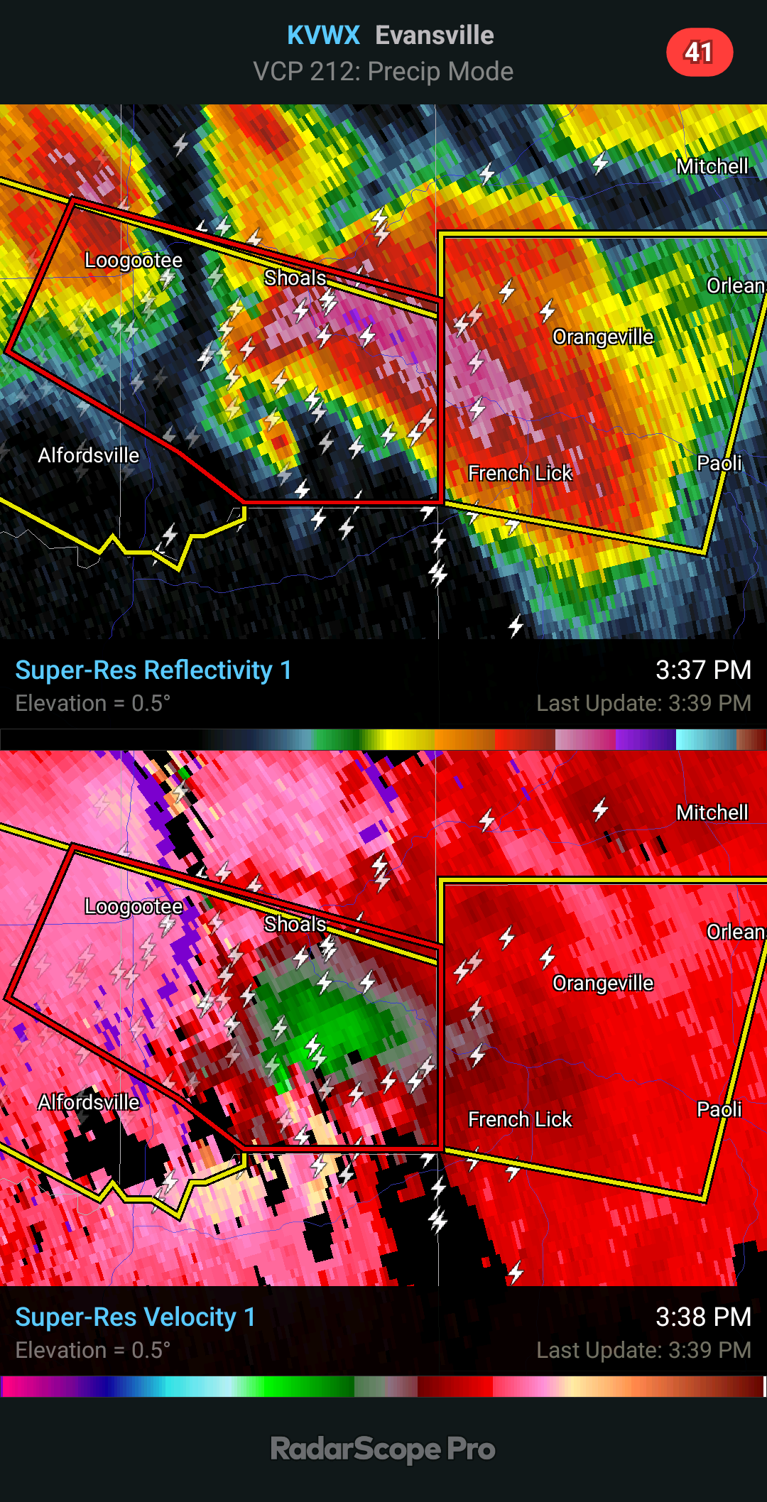
That's pretty bad. For something that intense and obvious. 20K+ feet is definitely indicative of a significant EF2+ tornado and possibly EF3+. It's unfortunate the warning went without confirmed or PDS in wording because maybe that could have prevented loss of life. Regardless it should be in warning for obvious reasons.
-
That's insane. How high was the TDS being lofted?
-
Unfortunately I don't have any at this time. I reached out but haven't heard back. Did the warning ever say confirmed damaging tornado? The radar and velocity presentation was exceptional and supportive of a strong to violent tornado like you suggested. I haven't seen any pics or video of a tornado or damage from this storm yet. I will let you know if I hear anything.
-
It appears that this storm may have produced a significant tornado that was never confirmed in the warning. A friend on FB just posted that their Aunt and Uncle's house was hit in Shoals. Unfortunately the uncle passed and aunt was life flighted for medical attention.
-
The headlights across from you are me and my chase partner. I didn't even see a car across from us get impacted. I'm glad you're okay man. Could have been way worse.
-
This is my chase partner's video. Ha. I was driving while he filmed. It was bigger before it got into town. I was flying to get out of the massive hail though. Briefly took shelter under this little building on outskirts of Table Grove but then the RFD really punched in and I didn't feel safe where we where. We pulled back out on east road and all of a sudden I heard it and here comes a cloud of debris. It was a small albeit pretty robust circulation.
-
Up in DVN. I like that moisture looks to pool and have more depth near wf later. Not going to lie TP play west is very tempting out near DMX but afraid moisture may mix out bad there. But with such a strong low and wf nearby man. I do like that models continue to show development of storms in ne MO and track them up this way later. However, I am a bit worried they may just shoot north over wf and not turn right and take advantage of parameters.
-
That's why it's convecting earlier because of the extreme mixing occurring. Hopefully doesn't come to fruition. 3km nam convects in ne MO into se IA but later than it was showing before and it looks to struggle.
-
I thought the same thing. Might just be the HRRR being special. Just crazy that it's been so consistent then derails now. Definitely something to watch.
-
Latest hrrr runs aren't firing anything now till 0z and now only in Iowa. Lol