Radtechwxman
-
Posts
2,481 -
Joined
-
Last visited
Content Type
Profiles
Blogs
Forums
American Weather
Media Demo
Store
Gallery
Everything posted by Radtechwxman
-
That isn't our system. That's the Aleutian low. Our system is a smaller disturbance rotating around the base of that low. Probably why models are struggling right now.
-
Here I was worried about a nw shift and now I'm hoping for one. Lol. Not digging this trend.
-
Other models taking a se shift esp Canadian. Ukmet looks like snow just dies over IL. Looks like possible thermal issues. Guessing euro will be more se than 12z run. 0z gfs is as good as it gets. If only we were closer. Would love to lock that in.
-
I haven't looked at anything for the weekend storm so I took the word verbatim. Should know better. Ha. But that also doesn't make me feel easy because I'm afraid of a last second nw trend with this one which will put me in mixing, rain, or dry slot. But like Chicago Storm said, still a lot of moving pieces to come together to see where this will track.
-
Just waiting for this storm to do the same. Lol
-
NO. DONT YOU DARE Yeah it's going to be close call for areas east with warm surge and dry slot screaming north. How north it gets will depend on sfc low position and strength. I'm not safe here in Peoria either. Euro brought mixing line and dry slot dangerously close. If things hold I'm good, barely, but if it trends anymore nw I may be out of it.
-
Euro definitely aggressive with that warm nose and dry slot into IL. Dangerously close here. Something to watch as these strong lows always pull up a lot of warm air and a big dry slot and models tend to underestimate them. Hoping track doesn't go anymore nw from where it is, ha. But nw trend wouldn't shock me one bit.
-
Explains the model chaos right now. I think noaa is sending out plans to get data at some point this week. Definitely need some sampling of our system.
-
Definitely afraid of a nw trend on this one with how strong the low is. I don't have a lot of wiggle room. Lol. Going to be a nail biter for sure. Key will be how quick trough goes neg tilt and how fast that low takes off because that's when it will start taking a more ne turn.
-
Literally my exact thoughts. Though that initially wasn't looking potent then trended that way and now has trended down. This storm has consistently looked like a big dog in long range and now medium range. But not going to lie, definitely nervous on a downward trend as it approaches.
-

Winter 2023/24 Medium/Long Range Discussion
Radtechwxman replied to Chicago Storm's topic in Lakes/Ohio Valley
12z euro doing similar situation to 12z gfs. Very limited cold sector precip for IL. Interesting turn on models today. -
Winter 2023/24 Medium/Long Range Discussion
Radtechwxman replied to Chicago Storm's topic in Lakes/Ohio Valley
Is that why the qpf is pretty meager except in narrow corridor? I been looking at the relative humidity and it looked fine from sfc up through 500mb. Surprised llj would be ripping on nw side with low like that. -
Winter 2023/24 Medium/Long Range Discussion
Radtechwxman replied to Chicago Storm's topic in Lakes/Ohio Valley
12z gfs evolution synoptically looks amazing but cold sector qpf seems to only be high in a very narrow corridor. The deformation band seemed kind of splotchy over a large area at first and then a more intense band close to low track which resulted in a wide swath of 1-3in and very narrow band of 6in+. Maybe some dry air issues? -
Winter 2023/24 Medium/Long Range Discussion
Radtechwxman replied to Chicago Storm's topic in Lakes/Ohio Valley
My exact concerns esp with the antecedent temps. Afraid most/all of the front end thump will be rain or mix which will hold back snow amounts some. Looks like dynamic cooling and cooler temps filtering in from nw in the deformation axis will be main if not only player for heavy snow. So we really will need that low to deepen sufficiently to wrap up that deformation band. Regardless could still be a high impact event with blizzard like conditions. -
Winter 2023/24 Medium/Long Range Discussion
Radtechwxman replied to Chicago Storm's topic in Lakes/Ohio Valley
I went to school with him actually. Western IL University. He tends to be more conservative with forecasting. -
Looks like eye started to fill right before landfall. May have weakened ever so slightly probably from land interaction with mountainous terrain. But NHC called it a 165mph landfall
-
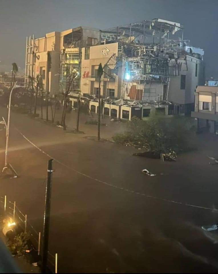
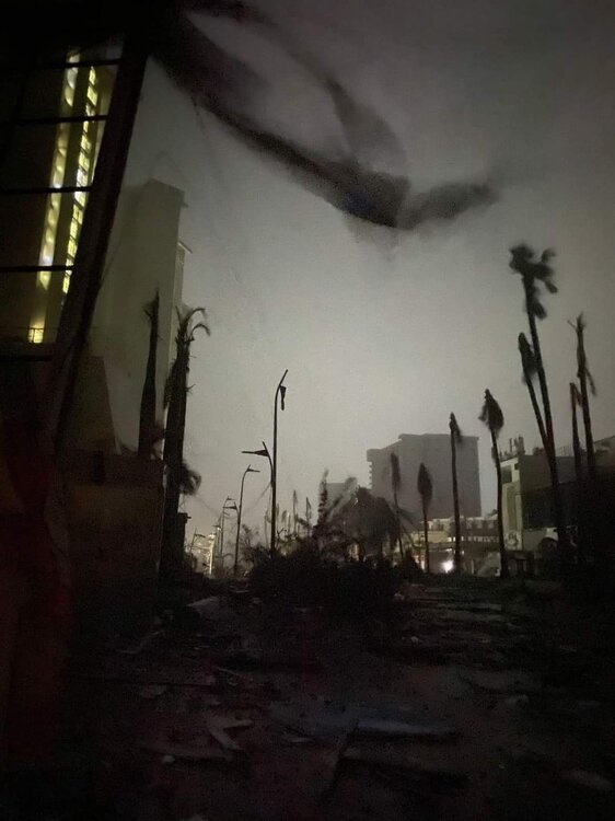
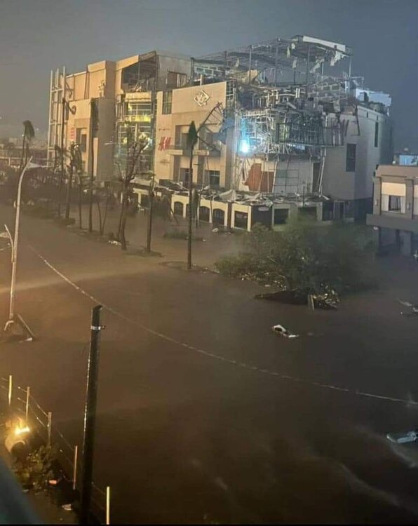
Reed posted these on his FB page. Unbelievable damage
-
I was hoping Josh would be there. Just to see footage from this. Going to be unreal. If anyone could pull it off, it would be him. Thanks everyone for looking into the radar situation. Too bad we have nothing to look at from that perspective but man this satellite imagery is wow.
-
Just may not have the funding like we do from government for NOAA. I mean look how outdated Canada's radars are. Not to get off topic. Would love to see Otis on radar. Also hoping for some HH footage.
-
I found a few sites that made it seem like I could view a radar from there but then loaded nothing. They also are really in the thick of it now so may be having issues.
-
Otis is just making a v-line for Acapulco. The satellite imagery just gives you a pit in your stomach. Those poor people
-
Is there any radar data to look at? Been searching but having 0 luck
-
Back to a cat 4 albeit high end. 155mph and pressure up a lot from last night 942mb. Lee definitely feeling the impacts of shear. You can see the restricted outflow on satellite in sw quadrant particularly.
-
Those are all valid points. Core was tiny and where it hit probably had no observation sites. As much as I would love to know the wind it produced on land, I'm glad it missed major population areas.
-
Wind reports seem very underwhelming for a high end cat 3 landfall. I guess part of that could be less populated area it's hitting. I haven't seen anything sustained hurricane wind reports or any gusts of major hurricane force.