

Radtechwxman
-
Posts
2,481 -
Joined
-
Last visited
Content Type
Profiles
Blogs
Forums
American Weather
Media Demo
Store
Gallery
Everything posted by Radtechwxman
-
I know it's nam and it's long range for it, but certainly looking like it could do something nice at 500mb. Taking on a negative tilt in TX and closing off. I'm guessing it would be more north like GFS.
-
Feel like we just saw this play out in models recently. Oh we did. GHD III. GFS was north. Euro way south and slowly came north each run. Nam looking more like GFS but curious to see more of evolution into Thurs of secondary wave.
-
Big differences aloft on euro. Northern stream trough digs much more south and is slower to depart which slows and shunts southern stream wave south. On gfs the northern stream trough initially digs south but then flattens and pushes east. This allows the southern stream piece to eject quicker and more north. It also took on a negative tilt which allowed a much stronger sfc low to develop ne. Euro has a much weaker sfc low south with a more strung out trough.
-
Whelp euro is drastically different from gfs. It has pretty significant icing here behind cf Wed night but secondary wave of wintry precip with low riding up the cf is significantly more south. I remember euro did this with last storm system as well then slowly nudged north to match gfs. Not saying it will but gfs is overall being more consistent run to run and euro is showing pretty different outputs each model cycle.
-
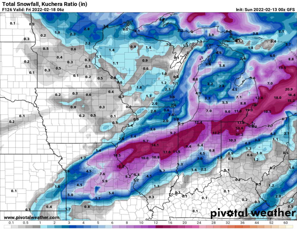
Kuchera map better imo because ratios will probably be better than 10:1 especially Thurs with rapidly falling temperatures behind cf
-
0z gfs back to being more amped up
-
Here's the time period where things look meh. 18z gfs not overly impressive. But still many days out and the energy still way out by Alaska. Still plenty can change for the better or worse.
-
Why is it so hard to get a nice phased system in the Midwest these days? Always seems to trend to strung out pos.
-
Models also tend to be too slow to eject upper lows out of the SW
-
Yeah he was talking about the same area being impacted not the amounts seen. This will likely be lower as it looks most of the QPF will fall in warm sector of this system and the deformation band of this will move through fairly quickly vs the last storm which was very long duration. But that's only if GFS is right. Latest euro just has some minor anafrontal wintry precip and no real wrapped up deformation band.
-
12z euro took a big dump on this run. The secondary low never really takes off so you don't get a nice wrapped up deformation band of wintry precip behind the cf like GFS has. A lot of moving pieces with this. Curious to see how it evolves.
-
Man 0z euro came in all sexy to
-
Man I would love 0z gfs to verify. To get to back to back double digit snowstorms within a few weeks of each other. But being 6 days out, we will still see major shifts in models and anything is still possible. Big ol' tease.
-
Definitely a little under what was forecasted for your area but still a great storm for you!
-
Hard to measure because of drifting but several reports anywhere from 10-12in around me. Was a 12in report on my road to the east and 11in+ report just to my south. Peoria airport to my southwest had officially 10.6in. Definitely best winter storm I have had in years. Had many periods of moderate snow and several of heavy snow. One thing I found interesting was that flake size overall through the event was pretty small but we still managed to get good totals probably owing to good ratios with very cold temperatures. The two things I wish that happened was for wave 2 to hit up here also and for more wind during the snowfall. But it was still a great storm. I got my double digit snowfall and I'm happy
-
At this point do we trust globals though or start looking more at short range hi res guidance? Honest question. Always wondered at what point do you shift away from globals. I see 12z euro joined nam in missing wave 2 here and also downing my totals for wave 1. Not sure what to think.
-
Yeah the 2nd wave seems to be trending more and more se. We pretty much get everything from 1st wave. I was reading where some warmer air aloft could impact ratios though. I think LOT mentioned it. Curious if that will impact these big totals models are putting out.
-
Hoping that isn't just a tease. Hrrr/rap are good at luring you in then tear out your heart strings. Lol
-
12z nam still a decent hit here with 1st wave but it ends it early compared to other guidance. Nam also misses my area with 2nd wave which honestly wouldn't shock me. Hrrr/rap are being consistently more aggressive with 1st wave lasing longer here and also getting me more into 2nd wave. Million dollar question is would you trust it? I'm definitely skeptical.
-
Definitely looking like a one wave show for me now but 1st wave looks like it could really deliver big. Hopefully the banding will setup over me. Some models have it really close. Most models barely skirt my area now with 2nd wave. A bit disappointing because I was excited for 2 huge waves of heavy snow but I will take what I can get. Hoping I can still break double digits. It will be close. Some sharp gradients near me. Sharp cutoffs nw and sharp increases se. Movements in track either way will drastically change my outcome. Forever riding the line here. Someday I will be in the jackpot zone again. Ha
-
I knew I shouldn't have got excited yesterday. Man these trends today have me greatly concerned. I'm glad gfs and euro still look good here but concerned nam is shifting so south. However, it is nam so take it with a grain of salt.
-
Just hoping models either hold where they are or bump slightly north again. I'm on northern fringes of heaviest snow swath. Anymore southern shifts and my totals will decrease drastically. Definitely nerve-wracking
-
Like I told you before, you're golden. Enjoy it. You're getting Appreciate the vote in confidence
-
Good ol' model emotional whiplash. Some models north, others south. Definitely a little nervous a south trend may continue again. Hoping at this point it will be just be small bumps north or south. I haven't had double digit snow in a while now. This looks like my best shot.
-
LOL. I wouldn't worry man. I honestly still think you're fine man. Don't let NAM worry you. GFS and Euro wallop you. I wouldn't be shocked if this trends south again. Anything is still on the table. I still think you're in a better position than me imo.


