Radtechwxman
-
Posts
2,481 -
Joined
-
Last visited
Content Type
Profiles
Blogs
Forums
American Weather
Media Demo
Store
Gallery
Everything posted by Radtechwxman
-

Feb 17-19th Potential Of Potential
Radtechwxman replied to Chicago Storm's topic in Lakes/Ohio Valley
I mean NAM nailed this storm being much more west so it's possible. But would like to see more support from other models. -
Right. The Peoria dome is strong. Hoping to see things ramp up soon.
-
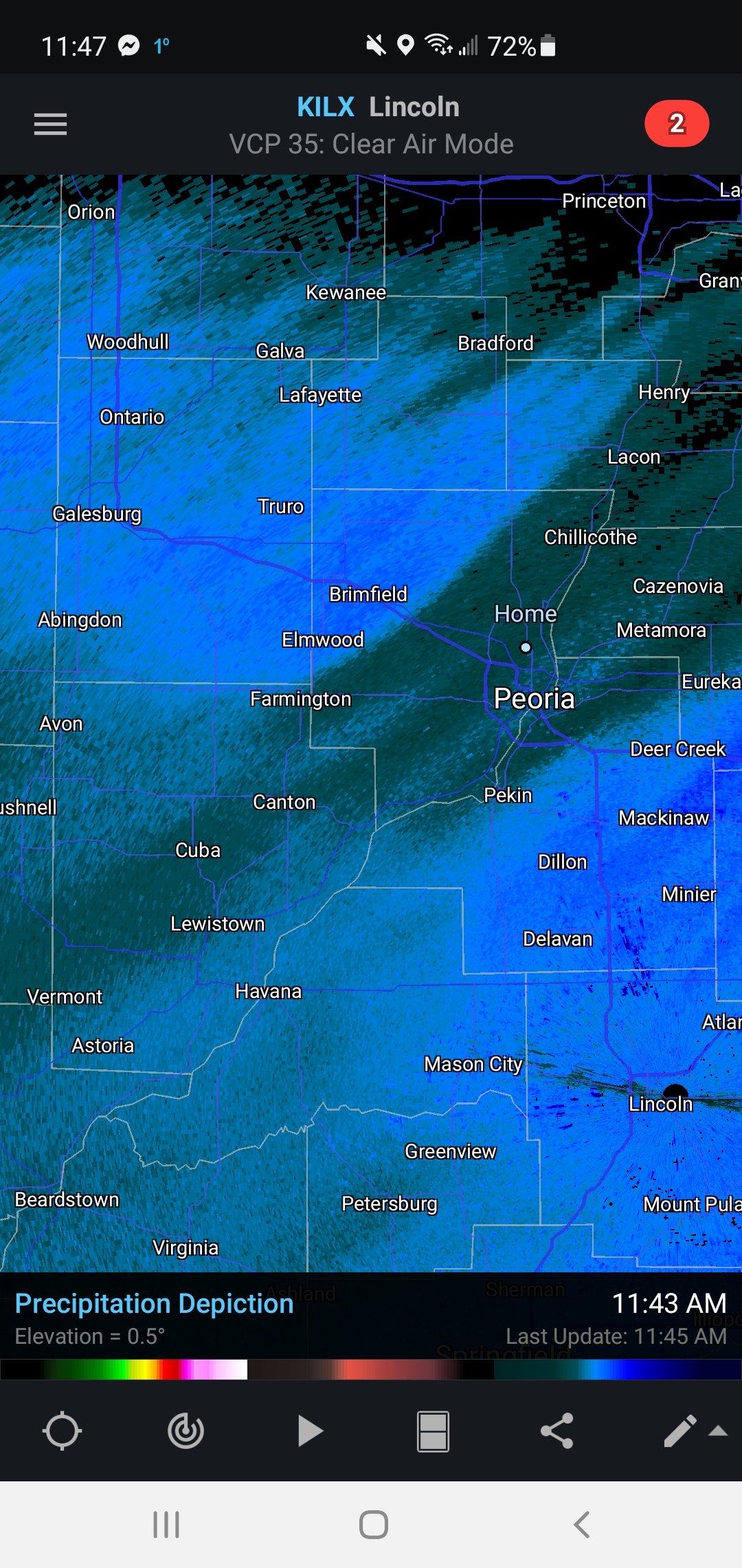
First initial push of snow on northern edge kind of poofed over me but looks like some mod to heavy snow is pushing in soon south of this.
-
Peoria dome ftw

-
Feb 17-19th Potential Of Potential
Radtechwxman replied to Chicago Storm's topic in Lakes/Ohio Valley
Globals still wanting to keep this east. Gfs way east and gem more east than it was before. Will nam sniff out another nw trend or will this one be truly east this time? That's the million dollar question. -
Yea they tend to follow their guidance very closely and ignore most hi res guidance. Ha
-
Been in their forecast area my whole life and it's a common theme. They usual low ball and continually bump up through event. Ha
-
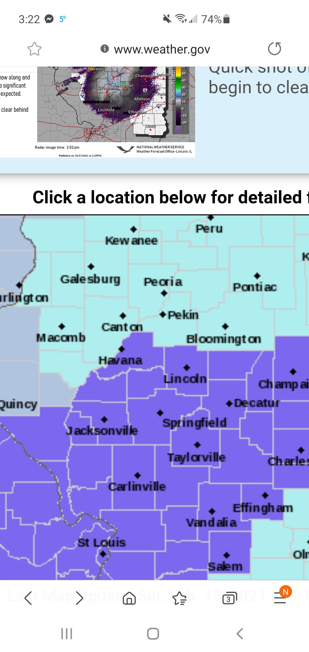
I don't believe it at all. ILX is way underestimating this. I think event total here will easily be 5-7in in metro Peoria.
-
Feb 17-19th Potential Of Potential
Radtechwxman replied to Chicago Storm's topic in Lakes/Ohio Valley
Anyone think we will see this trend nw like current storm did? -
Wave last night did better than I thought. Easily 2in here. Deformation band looks to be developing nicely down south. Upper low looks lovely on water vapor taking on negative tilt.
-
Feb 17-19th Potential Of Potential
Radtechwxman replied to Chicago Storm's topic in Lakes/Ohio Valley
Will be interesting to see if this ends up similar to current storm like nam suggests or a more sheared out way suppressed like gem and euro are suggesting. Gfs still pretty wrapped up. At about the same location as this current storm was at that time frame. -
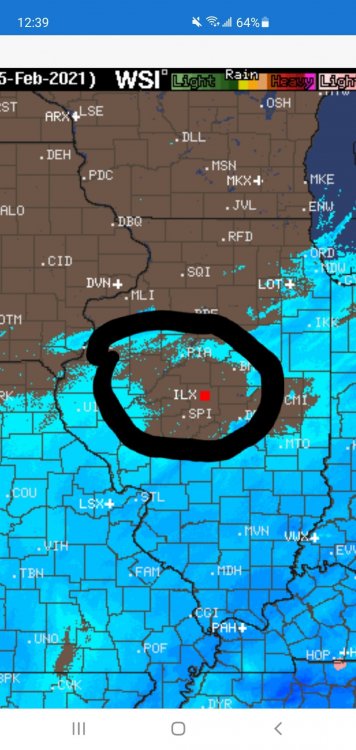
Seems like this initial appetizer snow is setting shop right now from STL to Champaign. Hoping we see the snow blossom more to the north like models suggest.
-
At this range I really don't put much stock in globals anymore unless they all started drastically shifting. I stick with hi res guidance at this point as they will be better at grasping short term trends.
-
This system is fascinating. Pretty rare to see big snows very far west from sfc low track. Upper level low nearby and good moisture feed into massive cold sector really driving a nice spread the wealth snowstorm. Hoping next storm can be more nw than what gfs/euro show currently. Would be awesome to close out this cold snowy pattern with two nearly back to back snowstorms.
-
Feb 17-19th Potential Of Potential
Radtechwxman replied to Chicago Storm's topic in Lakes/Ohio Valley
Not to get greedy but would be AMAZING to get two back to back big snowstorms here. Esp after all winter has been lamefest minus NYD storm. Hoping that one can trend nw last second like this current one did. Long range nam looks similar to what it did for the current storm at this range. -
And ILX be like 1-2in sounds good area wide
-
Yea they rarely do. Very last second on everything. Even are local TV mets are going higher.
-
Compared to globals yes but they have support from both RAP and HRRR
-
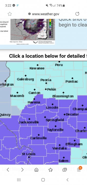
Yeah I have no clue what ILX is looking at. Not only should there be an advisory area wide but they could honestly about bring warnings up to the IL River. ILX loves to do everything last second but this is pretty ridiculous based on current model trends. Looks like this system could give me a bigger snow than the 2nd system now.
-
Feb 17-19th Potential Of Potential
Radtechwxman replied to Chicago Storm's topic in Lakes/Ohio Valley
Now looking like this 1st system might be my better shot at significant snowfall with models shifting east once again with this system. But wouldn't be shocked to see it trend nw again after this current system passes and models can resolve its snowfall foot print. -
Feb 17-19th Potential Of Potential
Radtechwxman replied to Chicago Storm's topic in Lakes/Ohio Valley
0z Canadian looked nice. 0z gfs was a bump east but I'm sure we will see plenty of wobbles especially till after this first system gets resolved and until we get better sampling of the jet responsible. Holding hope this can finally be my best winter storm of the season. -
Literally makes 0 sense. Like the snow continues up into our area with similar amounts. HRRR was the driest with 2-3in but other models had 3-5in+. Glad you're getting in on the action finally.
-
Really confused why ILX didn't extend advisories north. Pretty much all models extend the snow south of advisory criteria well north.
-
Feb 17-19th Potential Of Potential
Radtechwxman replied to Chicago Storm's topic in Lakes/Ohio Valley
WPC 3-7 day sfc maps definitely seem more in support of Euro and Ukie like solutions with a sfc low very south and east. Curious to see how this evolves. Not sure if it will stay really south following the snowpack from first storm or if it will come more nw with the block to the north backing off somewhat by mid week. -
Feb 17-19th Potential Of Potential
Radtechwxman replied to Chicago Storm's topic in Lakes/Ohio Valley
Really won't know till we see what this system does. And where the PV anomaly is by mid week.