nwohweather
-
Posts
3,818 -
Joined
-
Last visited
Content Type
Profiles
Blogs
Forums
American Weather
Media Demo
Store
Gallery
Everything posted by nwohweather
-
Absolutely not toss worthy. Hard wish casting by a pro right here
-
Tomorrows southern severe outbreak is going to play a huge role on the snowy side of things. Just too likely that intense convection is going to rob the backside of the storm of moisture, 3-5” except back towards the IA/MO/IL border is probably best bet.
-
Could get interesting for sure

-
On track to finish December with 19 of 31 days with highs in the 70’s here. Even with a few chilly days looks like our average high is going to be 69°, that’s 9° above average for December. Glad to see you’re getting a little winter weather in the region, gives me hope for some “Fall” weather
-
On track to finish December with 19 of 31 days with highs in the 70’s here. Even with a few chilly days looks like our average high is going to be 69°, that’s 9° above average for December. Glad to see you’re getting a little winter weather in the region, gives me hope for some “Fall” weather
-

Fall/Winter Banter - Football, Basketball, Snowball?
nwohweather replied to John1122's topic in Tennessee Valley
I figured it’d have to be warm up there as well. I’ve been routinely running my AC here in Charleston the last few weeks -
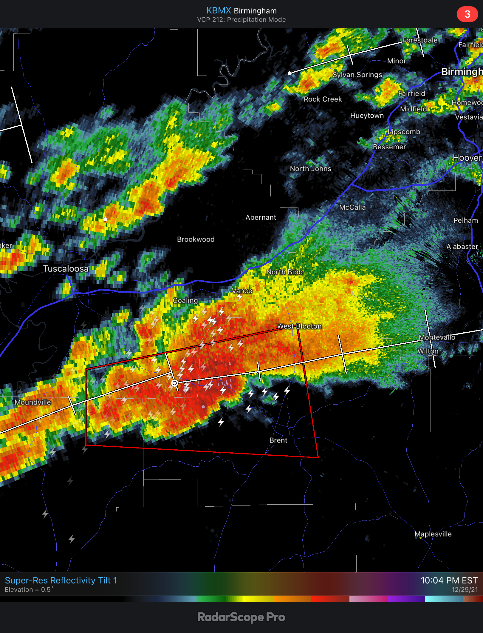
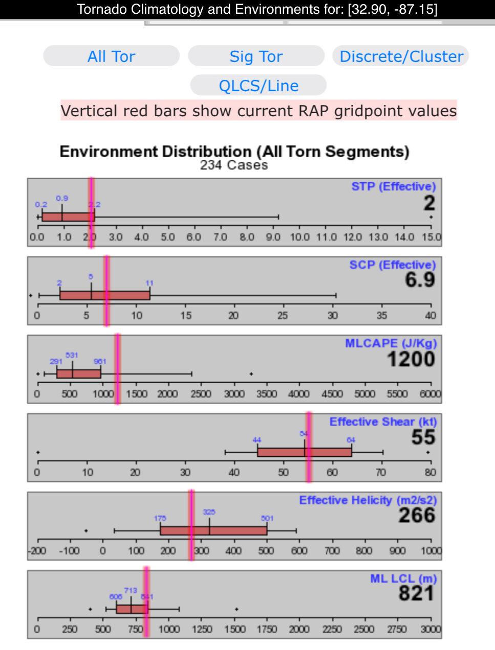
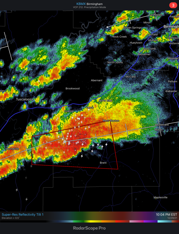
Lots of CIN really putting a lid on tonight. If it wasn’t for that, we’d have likely a significant outbreak tonight
-
Tons of shear aloft and decent SRH, but looks like some solid CIN is really putting the lid on this evening. Just nothing really taking off despite a Tornado Watch that is cautioning for even intense tornadoes. I’m just not seeing it here
-
Right lol? I certainly do. Today hasn’t been the most lively day though, just a couple notches in the line
-
That environment is gonna pop off at 3-4 Central here. I’d be real worried in N MS today, strong LLJ with little CIN and ample instability
-
Might get a little busy on this thread here today
-
Looks pretty dicey along and north of the I-20 corridor today if the instability can build following the morning rain. SRH is actually forecasted to be pretty damn high and the morning activity should put down a nice boundary back in AL/MS/TN
-
I just feel like IWX & CLE are vastly underdoing this event. These events are always a heavy shot of snow before turning to a mix & rain, should be an easy 2-4" for those areas. CLE is out here saying maybe an inch? 100% expect a WWA this afternoon once this thing arrives
-
I like 2-4” for Toledo
-
Mid to Long Range Discussion ~ 2022
nwohweather replied to buckeyefan1's topic in Southeastern States
Completely and I absolutely love it. I don’t see Charleston dropping below 75° at all this week for a high. Big fan of this torch -
Mid to Long Range Discussion ~ 2022
nwohweather replied to buckeyefan1's topic in Southeastern States
I had my legs in the pool today! I cannot complain at all. As fun as snowstorms are, an 80° holiday week is so relaxing -
What a perfect day on the coast. Nice breeze with temps in the upper 60s and sunshine. Merry Christmas everyone!
-
Mid to Long Range Discussion ~ 2022
nwohweather replied to buckeyefan1's topic in Southeastern States
With as much energy we’ve seen this year in both the hurricane season and lately out of the Pacific, you have to think there will eventually be a monster Nor Easter that clips many with snow -
Mid to Long Range Discussion ~ 2022
nwohweather replied to buckeyefan1's topic in Southeastern States
Insane looking at the models for the next few days here. Starting Friday is another extended stretch of weather you’d more likely see in Orlando or Daytona, not Charleston. I wouldn’t be shocked to see 80° hit on Tuesday or Wednesday a little inland. Just bonkers how the warm air will not subside in the South this year, you almost forget that the average high is indeed around 60° -
Yeah it seems quite apparent the Central Lakes region is in a period similar to what the 1990s were now. Since 2005 Toledo has had 3 of its 5 snowiest Januaries and 4 of the top 5 snowiest February’s of all time
-
If I’m not mistaken the winter of 17/18 was bitterly cold to start. We went 2 weeks there around Christmas without getting above freezing
-
I’m fine with that lol presents and food are overrated anyways. Seriously though I’m stunned at how warm meteorological “winter” has been here in 2021-22. Makes sense with a roaring Pacific though but crazy to experience
-
Have to really appreciate the shorts and polo weather for Christmas Eve golf. Next week looks pretty raw though
-
This warmth is so impressive. To be sitting outside at night in shorts and tee before Christmas is unreal
-
Exactly! Heck there were reports of asphalt being cracked and foundations suffering catastrophic damage. If you're going to use "improper building" as a reason to withhold an EF5 rating then basically the only chance of an EF5 rating is on the coastline in a hurricane zone. Regardless, I've seen an EF4 up close and it's damage. I'm not sure how you can get much worse than that anyways, it's beyond anything you reasonably even expect.