nwohweather
-
Posts
3,818 -
Joined
-
Last visited
Content Type
Profiles
Blogs
Forums
American Weather
Media Demo
Store
Gallery
Everything posted by nwohweather
-
 I’ve noticed SRH has ramped up significantly this evening and instability isn’t terrible. Mobile is definitely under the gun at the moment
 -
Looks like they're just warning the entire line. Really about to move in a better atmosphere over the next hour
-
I was thinking the same thing. Ours is obviously being buoyed by the ocean as that mirrors the ocean temp, but dews drop hard to below 50 once you reach even Charlotte.
-
I'd say so, looks like the low is trending a bit stronger than expected thus far. I can say anecdotally it's pretty warm and humid for March here even in South Carolina, I imagine closer to the low dews may take a run at 70 this afternoon. It's a pretty significant moisture transport into this thing, PWAT's are around 1.7 at the line currently
-
Man that atmosphere off to the east is getting absolutely primed. Not there yet though but certainly getting there for around lunch time
-
Yeah I’d agree with that. Hi-Res are showing legit supercells firing on the south side of that line in an environment that will have some serious spin. If I’m not mistaken SRH on soundings around Mobile was around 400-500
-
Yeah I believe projected winds around 100 MPH are required for a PDS T-Storm Watch
-
I get you there, but when I'm saying is I'm not sold on there being a bunch of tornadoes period. Only can really see it if this event evolves into more of a "string of pearls" look than a full fledged line which is unlikely
-
Regardless, I'm not nearly as bullish as the SPC here. Definitely looks like a major damaging wind event though, soundings show plenty of wind transferring down to the surface. We could even see a High Wind Warning as well for the area
-
Might as well call this the new Tornado Alley at this point. I'm just not sold on a legit QLCS tornado outbreak, very atypical despite awesome parameters. I saw this a lot while living in the Great Lakes, we'd have some powerhouse low roll through with out of this world dynamics, yet at the end of the day a line is a line. We'd get a ton of wind reports, but so often the tornado threat would lack considerably.
-
Whoa, that is very strong language. The upper level divergence is damn near perfect
-
2022 Short/Medium Range Severe Weather Discussion
nwohweather replied to Chicago Storm's topic in Lakes/Ohio Valley
Ooh boy might get warned quick
-
Well that's a shame. Today has potential but that MCS is probably going to cut off some of the moisture flow into the region
-
Definitely looks like a damaging wind day here in the Carolinas
-
Those are the best looking cells of the day
-
Just too messy of a storm mode at the moment
-
Almost wonder if it's peaking too early today. Everything popping on the line
-
I don't know I'm kind of leaning the other way, parameters are such today seems like the day for a potential "big one"
-
That line is going to put down a nice boundary for this evening
-
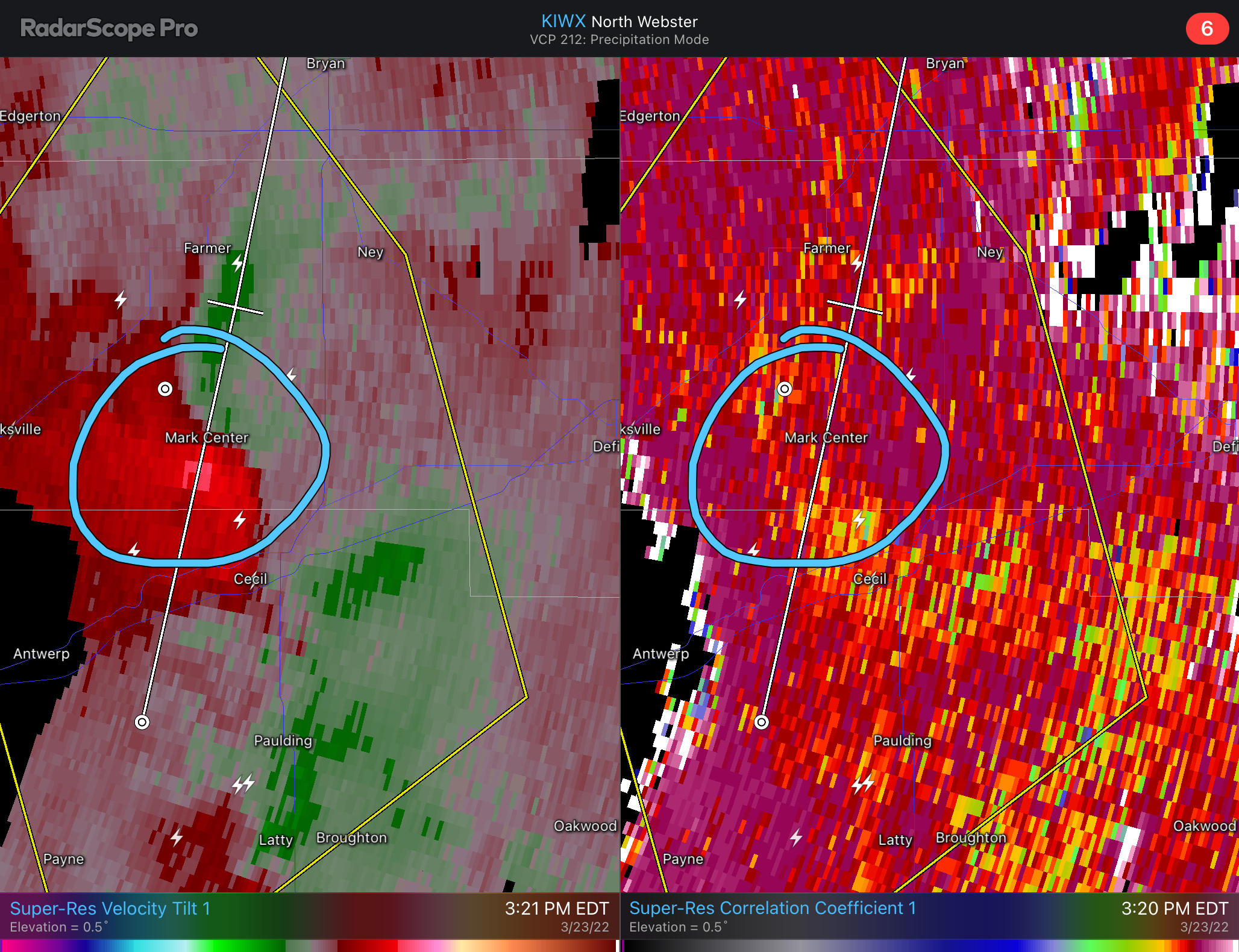
Yikes that’s bad radar coverage there
-
Holy balls
-
I figured once those cells got in the better shear/helicity this would get dicey. Atmosphere lined up well this evening
-
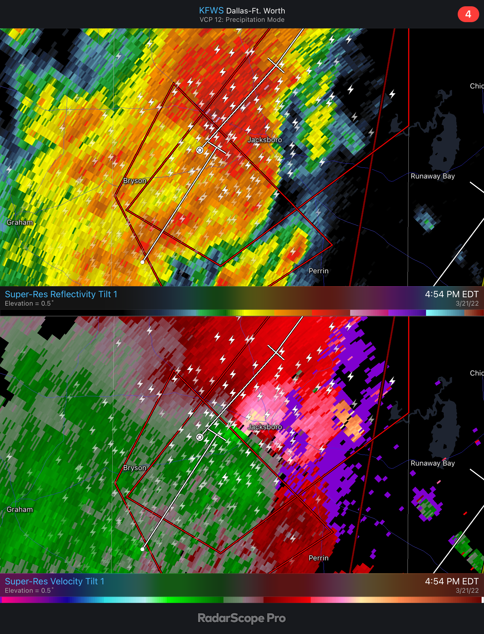
That cell east of San Antonio is ripe once it gets into a higher helicity environment. Great structure and a little isolated from the other cells, could see some serious hail and a strong tornado from it in an hour or so
-
That environment just to the east is significantly better. If this can line up, ooh boy. Great LCL’s and spin ahead of the line, but noticeably better lapse rates and instability where it is now
-
Rain wrapped tornadoes is an odd threat in TX