nwohweather
-
Posts
3,818 -
Joined
-
Last visited
Content Type
Profiles
Blogs
Forums
American Weather
Media Demo
Store
Gallery
Everything posted by nwohweather
-

2022 Short/Medium Range Severe Weather Discussion
nwohweather replied to Chicago Storm's topic in Lakes/Ohio Valley
Should we make a thread for today? I'll make one and if not just delete it -
2022 Short/Medium Range Severe Weather Discussion
nwohweather replied to Chicago Storm's topic in Lakes/Ohio Valley
It’s essentially a Louisiana airmass combining with Midwest dynamics, should make for a hell of a show. Glad you finished touching on the hail threat, with lapse rates approaching 8° it’s definitely a larger threat than usual for this region of the country. -
2022 Short/Medium Range Severe Weather Discussion
nwohweather replied to Chicago Storm's topic in Lakes/Ohio Valley
If that cap gives way tomorrow holy smokes… -
Haha love that swimming weather
-
Rejoining you guys for a week here on a work trip. What the hell is this Low 70's stuff?
-
90 here in Charlotte, about to have a roughly 35 degree drop when the plane lands in 2 hours! I haven't felt temps like that since March. Weather is cool as heck sometimes
-
2022 Short/Medium Range Severe Weather Discussion
nwohweather replied to Chicago Storm's topic in Lakes/Ohio Valley
Man that's a really good discussion -
2022 Short/Medium Range Severe Weather Discussion
nwohweather replied to Chicago Storm's topic in Lakes/Ohio Valley
Amazing structure on that cell. To be honest, I’m shocked it didn’t keep going longer as there was little around it to impede inflow -
2022 Short/Medium Range Severe Weather Discussion
nwohweather replied to Chicago Storm's topic in Lakes/Ohio Valley
Was one of the best looking radar shots I’ve seen out of Michigan. Not a big downtown so that’s some terrible luck for those folks that it literally went down main street -
2022 Short/Medium Range Severe Weather Discussion
nwohweather replied to Chicago Storm's topic in Lakes/Ohio Valley
Looks like ole Frosty was dead right -
Mid to Long Range Discussion ~ 2022
nwohweather replied to buckeyefan1's topic in Southeastern States
It’s been noticeable as well with the lack of humidity. Pleasant weather, but with this heat the ground is going to dry up very quick. -
Mid to Long Range Discussion ~ 2022
nwohweather replied to buckeyefan1's topic in Southeastern States
Ole mother nature turned up the heat this week eh?
-
93° today here in Summerville. For the first time this year it feels like HOT
-
Very disappointing to read. I've storm chased quite a bit growing up in Ohio with tons of open space and it really can be a fun time, just stay out of the precip and maintain a SSW angle to the rotation. This whole "zero meter" thing is absurd, tornadoes are big and can be viewed safely easily from 1-3 miles away
-
2022 Short/Medium Range Severe Weather Discussion
nwohweather replied to Chicago Storm's topic in Lakes/Ohio Valley
105 miles between IWX and CLE almost exactly -
2022 Short/Medium Range Severe Weather Discussion
nwohweather replied to Chicago Storm's topic in Lakes/Ohio Valley
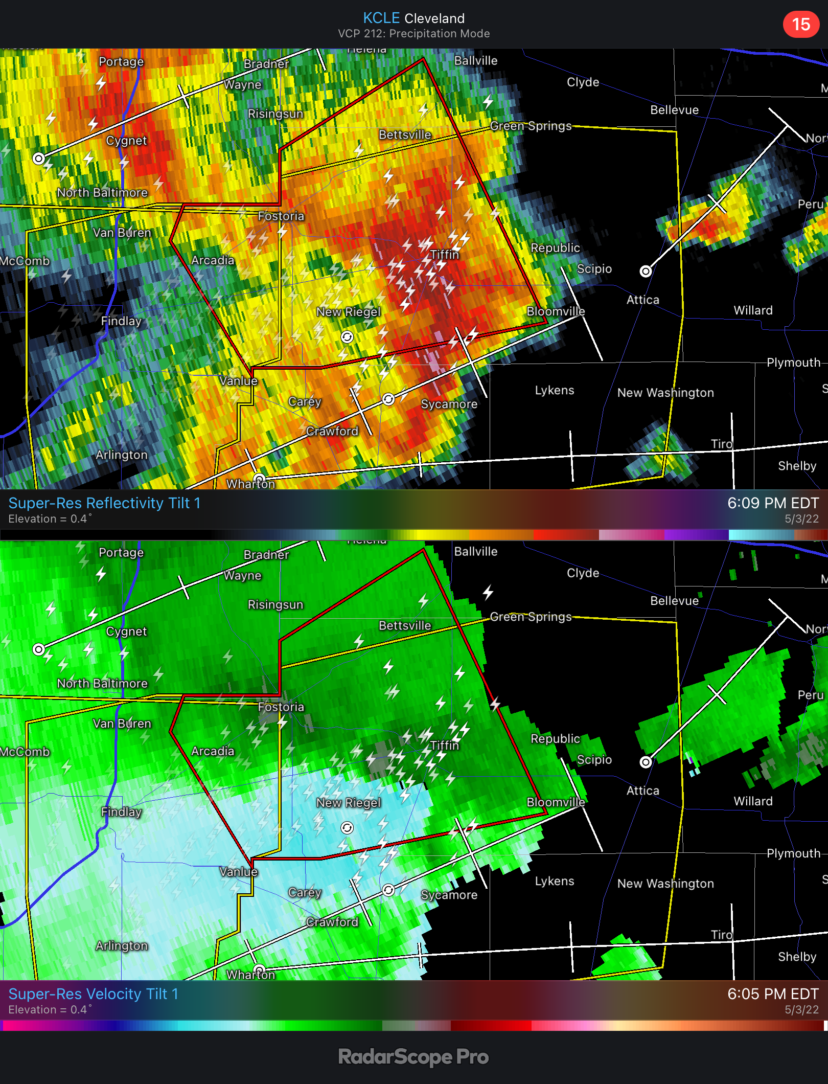
Solid storm in NW Ohio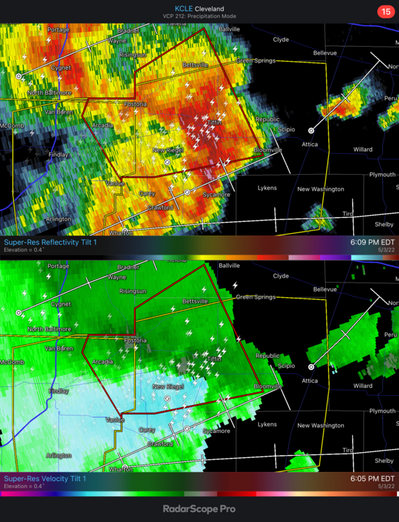
-
Yeah looks like the inflow was undercut. They lucked out for sure
-
Man that cell SW of OKC bears some serious watching. Absolutely ripe environment with instability & shear, plus LCL's lower once it gets to around I-35. If that mesocyclone can fully ramp up now...
-
I’ve noticed significantly more SRH is to the east of these storms. If they don’t line up too soon, could see tornadoes shortly
-
Wow, several strong tornadoes likely is quite ominous. I will say as someone who lives in South Carolina but grew up in the Detroit/Toledo area, it's amazing to see how stark the difference has been in weather between the Sun Belt and Northern US this season. Until the CONUS levels out a bit temperature wise I think we're going to have a rocky road to June. Overall I have to say I'm super impressed at how many setups have had terrific ingredients this year for intense/violent tornadoes
-
Almost a completely unstable environment there
-
I could see things absolutely going off about 5 hours from now. That's a very primed environment with an eroding CAP. Also if I'm not mistaken that low is deeper than modeled, already down to 994 MB in WC Kansas
-
I would target Wichita tomorrow if I were out there. Seems like there's going to be enough lift tomorrow kick off some storms through that cap, and there is some serious wind aloft and moisture being pumped into the region with dews in the mid to upper 60s. I'd lean that late tonight/tomorrow morning we see a MDT risk as the ingredients in play do favor a strong tornado threat
-
Only way to get this kind of heat in April is to pump it in up there
-
I'm sorry for you guys lol