

nwohweather
-
Posts
3,818 -
Joined
-
Last visited
Content Type
Profiles
Blogs
Forums
American Weather
Media Demo
Store
Gallery
Everything posted by nwohweather
-

The Appetizer: Light Snow general 1-2 " event 1/22-1/23
nwohweather replied to Baum's topic in Lakes/Ohio Valley
Best snow of the year here in Perrysburg! -
The Appetizer: Light Snow general 1-2 " event 1/22-1/23
nwohweather replied to Baum's topic in Lakes/Ohio Valley
Definitely looks like a solid 2-4” incoming, snow wasn’t supposed to start until 10 AM yet it’s coming down pretty good at the moment -
Midwest/Ohio Valley/Great Lakes Snow January 24-26
nwohweather replied to Baum's topic in Lakes/Ohio Valley
This type of storm track is typically a solid 6-10” for the region absolutely. Still the model spread won’t be clear until Monday night -
Midwest/Ohio Valley/Great Lakes Snow January 24-26
nwohweather replied to Baum's topic in Lakes/Ohio Valley
Northwest Ohio getting crushed Hr 114 just means that this is for sure heading for Detroit -
Midwest/Ohio Valley/Great Lakes Snow January 24-26
nwohweather replied to Baum's topic in Lakes/Ohio Valley
Definitely has the feel of a nice 6-10" in the main swath, ample moisture for sure with this thing at the moment. -
Winter 2022/23 Short/Medium Range Discussion
nwohweather replied to Chicago Storm's topic in Lakes/Ohio Valley
Why? A gulf low running up to along the Ohio River is a historically great track for the lower Great Lakes in general before transferring off the coast. -
2023 Short/Medium Range Severe Weather Discussion
nwohweather replied to Chicago Storm's topic in Lakes/Ohio Valley
Could see some wild helicity numbers in western Ohio tomorrow -
Winter 2022/23 Short/Medium Range Discussion
nwohweather replied to Chicago Storm's topic in Lakes/Ohio Valley
That storm track looks so damn promising next week for Toledo -
2023 Short/Medium Range Severe Weather Discussion
nwohweather replied to Chicago Storm's topic in Lakes/Ohio Valley
Definitely looks like a damaging wind type of day tomorrow, would be cool to see some spin-ups though -
Winter 2022/23 Medium/Long Range Discussion
nwohweather replied to Chicago Storm's topic in Lakes/Ohio Valley
NW Ohio sitting very pretty for Sundays event. As the heat miser I’ll do my best to keep the snow away -
January 12th 2023 Enhanced Severe Threat
nwohweather replied to kayman's topic in Southeastern States
It’s so cool how they post these live now. To say look there’s an EF3-4 barreling through as we speak really gives clarity to all -
Get the hammock out
-
January 12-13 Thread the Needle Snow Event
nwohweather replied to Hoosier's topic in Lakes/Ohio Valley
I like your odds in Huron better than here -
Where have all the cowboys (I mean clippers) gone?
nwohweather replied to Hoosier's topic in Lakes/Ohio Valley
Explains why the TN Valley over into the mid South gets severe outbreak after outbreak. Also who needs clippers from the Pacific when you can get atmospheric rivers? -
January 12-13 Thread the Needle Snow Event
nwohweather replied to Hoosier's topic in Lakes/Ohio Valley
NAM is a little more bullish with backend precip and with the southeast trend post sampling I wouldn't be shocked to see 1-2" of accumulation across NW Ohio east of I-75. The warm ground and temps hovering around freezing won't help with accumulation but I expect some decent snowfall for a short time in the overnight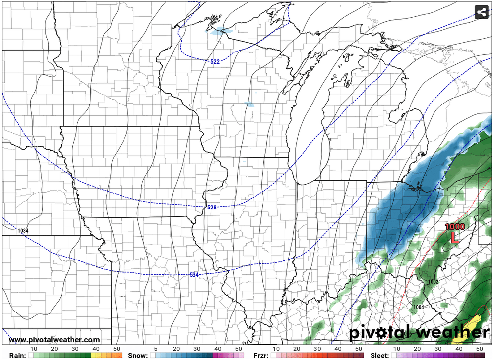
-
January 12-13 Thread the Needle Snow Event
nwohweather replied to Hoosier's topic in Lakes/Ohio Valley
Mid January and no cold air for a sub 1000 mb low to drop snow. Climate change for the win -
January 12-13 Thread the Needle Snow Event
nwohweather replied to Hoosier's topic in Lakes/Ohio Valley
The ole NW Ohio dryslot hitting hard on this at the moment but it brings Detroit proper in as well. Still a lot of spread, GFS showing a nice Chicago to Traverse City special there. Still not overly impressed with the cold air in place, I think that cuts down snow totals from what the models are showing -
Winter 2022/23 Short/Medium Range Discussion
nwohweather replied to Chicago Storm's topic in Lakes/Ohio Valley
Always. I mean our gold has always been the Apps Runner -
Winter 2022/23 Short/Medium Range Discussion
nwohweather replied to Chicago Storm's topic in Lakes/Ohio Valley
What a nice little surprise here eh? Verbatim it’s 3-6” for NW Ohio with maybe a little lake enhancement occurring for Ottawa and Erie counties. As others have said though there’s a good bit of warm air to overcome, need the low to trend a little stronger here to wrap more cold air in -
Late next week looks interesting, just a real lack of cold air for a lot of these little systems. Weird to see in January
-
I guess it's not going to snow this year eh?
-
Tough scene
-
Looking like 1-2” of rain with temps in the low 60s here tomorrow. I know it’s not snow but pretty anomalous for this time of year, wouldn’t be shocked to even have some rumbles of thunder. Other than that looks like a pretty dreary stretch until this pattern breaks
-
Winter 2022/23 Medium/Long Range Discussion
nwohweather replied to Chicago Storm's topic in Lakes/Ohio Valley
Keep it away! There’s no place for sub 50° highs -
As always, appreciate the historical context you bring to this forum


