nwohweather
-
Posts
3,818 -
Joined
-
Last visited
Content Type
Profiles
Blogs
Forums
American Weather
Media Demo
Store
Gallery
Everything posted by nwohweather
-
Peak weather. Up here for the week, loving it after golfing this weekend in 92°/80° weather
-
I’ve seen 6” in a day since moving to Charleston and I cannot believe what a full foot would look like. Basically like being under a water park bucket
-
Not often you see the catastrophic flooding tag on a warning
-

Summer 2022 Medium/Long Range Discussion
nwohweather replied to Chicago Storm's topic in Lakes/Ohio Valley
Ahh that’s a good point. Hell I’d even see hard gradients when I lived in NW Ohio. There’d be April days where you’d see temps of 55° in Toledo with an east wind but 75° around Findlay/Lima. It’s truly amazing how different places like Toledo/Cleveland are compared to even Columbus in climate -
Summer 2022 Medium/Long Range Discussion
nwohweather replied to Chicago Storm's topic in Lakes/Ohio Valley
If I’m not mistaken that was followed by an active Fall severe weather season as well. I remember 2018 being a pretty hot year as Toledo reached 90° 44 times which is impressive as hell considering it’s proximity to the lake. What I couldn’t imagine up there would be the heat waves during the Dust Bowl. I’d love to see what those surface maps looked like with the Great Plains essentially being Phoenix East. I do say all of this by the way while sitting at my pool in Charleston with current conditions of 91°/77° so I’m definitely jealous of your June-August climo -
Now you know what it feels like here from June 1-September 15
-
Glad this took off like it did. Was cool to watch for sure, the banding and swirl were obvious on both radar and eye sight yesterday evening in Charleston
-
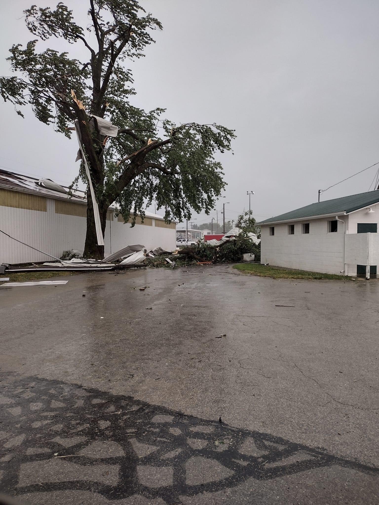
Apparently significant wind damage just occurred half hour ago in Fremont OH just west of Sandusky. Getting reports of lots of damage across the city

-
It’s gonna be a rough evening across Charleston. Consistent 25-40 mph winds with heavy rain in that band approaching Seabrook
-
Tightened up a bit with winds 30-40 mph in that band above the center
-
The banding and humidity is so damn tropical. Currently 77 with 100% humidity
-
2022 Atlantic Hurricane Season Tracking Thread
nwohweather replied to WxWatcher007's topic in Mid Atlantic
It's just so well defined and convection appears to be strengthening over the Gulf Stream -
2022 Atlantic Hurricane season
nwohweather replied to StormchaserChuck!'s topic in Tropical Headquarters
Honestly though how is this not a system? Defined center, has its own moisture transport and has it's strongest winds in the NE quadrant of the "eye". If you get some sustained 40-45 that'd be enough -
2022 Atlantic Hurricane season
nwohweather replied to StormchaserChuck!'s topic in Tropical Headquarters
What a look on the radar -
What a wild storm complex. Damn thing has the swirl of a cinnamon roll
-
2022 Short/Medium Range Severe Weather Discussion
nwohweather replied to Chicago Storm's topic in Lakes/Ohio Valley
5!? SPC definitely called it today -
2022 Short/Medium Range Severe Weather Discussion
nwohweather replied to Chicago Storm's topic in Lakes/Ohio Valley
Damn, the strongest winds are headed straight for Green Bay -
Must have been insane to see that from a plane. Always love flying around thunderstorms, to see a storm twice as high as you at cruising altitude is a purely intimidating thought. Here’s one from a recent flight over the ocean
-
Absolute powerhouse ripping through IN/OH right now
-
Not sure how strong the line will be here with so much CIN in the region. Tons of instability but we’ll see how much this thing can max out as it progresses. Hail has definitely been impressive for the Great Lakes today
-
Sheesh on the shear and SRH. Per the mesoanalysis it looks like some CIN still needed to be eroded
-
Wouldn't be shocked at all to see that cell approaching Van Wert become tornadic. Nothing around it, cap is eroded there and decent shear, helicity
-
Toledo or somewhere on US 6 or US 20 between Fremont & BG or Fremont & Perrysburg is your best bet. Very Oklahoma like setup with tons of open fields. Plus US 6 gives you the ability to head west without traffic if need be
-
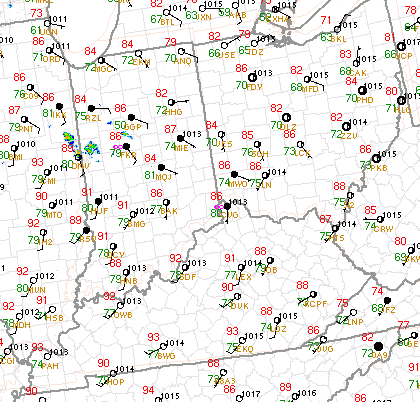
Absolutely stunning dewpoint readings. Central/Southern IN is as oppressive as it is in Charleston at the moment combined with good shear & lapse rates. I have to think we go Moderate once the line gets rolling into a bow echo
-
I'll start to separate this from the general thread