

Steve
-
Posts
1,017 -
Joined
-
Last visited
About Steve

- Birthday 09/07/1960
-
Let’s talk winter!! Ohio and surrounding states!! 24'-25'
Steve replied to buckeye's topic in Lakes/Ohio Valley
Can we actually get lucky this time.. -
Let’s talk winter!! Ohio and surrounding states!! 24'-25'
Steve replied to buckeye's topic in Lakes/Ohio Valley
I’m here .. been off work for awhile and really just forgot.. -
Let’s talk winter!! Ohio and surrounding states!!
Steve replied to Steve's topic in Lakes/Ohio Valley
So we get some cold… but no storms on the 10 day forecast… Lol… then at the end of 10 days…40’s! -
Here we go again…. Let’s hope winter doesn’t disappoint us this year!
-
For once we get an over performer!!
-
My SREF plumes was at 2 inches… now at 5!
-
Seems like the front is slowing down some to this untrained eye …the snow is looking good… 3-5 seems a good bet..
-
Should of posted this…. Not my write up… wish I was that good.. Got it from SWC forecast center… out of Ohio..
-
Not saying this will happen… but there is still hope..
-
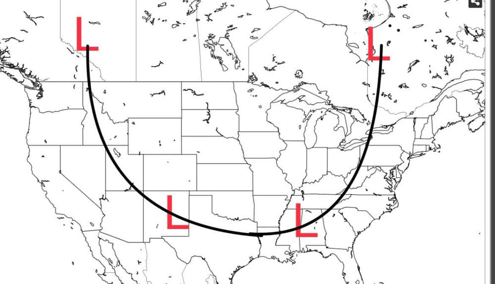
Latest SWC ideas on the end of week storm. It will be a rapidly, deepening storm. The bitter Arctic air slamming into a moist, subtropical jet will set the stage for low pressure to ”bomb” out over the Ohio Valley. The system is crossing into southwestern Canada this evening. As better sampling becomes available, more specifics can be ascertained. If we look at the 12z model suite from Monday afternoon, the storm projected East. In this case, a slightly colder look, earlier than other runs. Will the trend continue? That is unknown; however, the energy in the Pacific appears a bit weaker. This leads to a little less amplification, or a flatter movement of the storm system. What this means is a little more south and East projection of the surface low. The problem is 50 miles will mean a great deal. Specifics simply cannot be made, currently. What can I tell you? Pretty sure the storm will start out as a period of rain. The latest guidance seems to rush colder air in here faster Thursday evening into Friday morning. This would imply a changeover to snow, sooner. So earlier changeover means more snow. Wind will likely end up being the most noticed issue from this storm. As the surface low rapidly deepens, winds will howl. Sustained winds over 40 mph with gusts to near 60 mph seems likely at the height of the storm. With the snow, regardless of minor or major, blowing and drifting snow will become an issue. It is with some certainty that areas in the region will experience blizzard conditions. Flash freeze conditions come next. Temps in the 30s and 40s will nosedive into the single digits and teens. With the wind, wind chill temps will be below zero. So be prepared for an abrupt change in air temperature. The hardest issue is track. What I am going to do is hazard a guess with track of this system. I truly feel that the cold is still a bit underestimated by models and the blocking over northeast Canada up into Greenland is being underplayed. This is why the 12z model trended east, and believe a bit more east movement is possible. The farther east this tracks, the more areas that could see more snowfall. I will try to zone in tomorrow and Wednesday on specifics, but as I sit here Monday evening, I still do not have that much confidence on what this storm will do. It is the fact that this storm could deepen so rapidly that models are still missing a key piece or two that can greatly alter the outcome of this storm. All I can say is stay tuned for future updates. What I will do is give you my track idea at this point in time. No real specific, again, but once you are east of the low, cold will scream in rapidly and expect snow soon afterwards. This map will change, but right now this is my idea.
-
Just sitting back looking at the models…I’ll just say things look interesting…I try not to get to excited…the older I get(62) I try to save my ❤️when it does happen… only 4 days away… we shall see…we know for sure the cold is coming!
-
Really late this year.. looks like things could get interesting this winter..
-
Can’t believe not a bit of snow!!
-
I’m resigned to the fact that a sleet storm it is..
-
Still a sleet fest here..


