nwohweather
-
Posts
3,818 -
Joined
-
Last visited
Content Type
Profiles
Blogs
Forums
American Weather
Media Demo
Store
Gallery
Everything posted by nwohweather
-

Mid to Long Range Discussion ~ 2022
nwohweather replied to buckeyefan1's topic in Southeastern States
Agreed. If I’m not mistaken Halloween last year was the first day I legitimately needed a hoodie -
There is some serious wind up and down this massive line. In Kentucky and Mississippi there’s for sure hurricane force winds
-
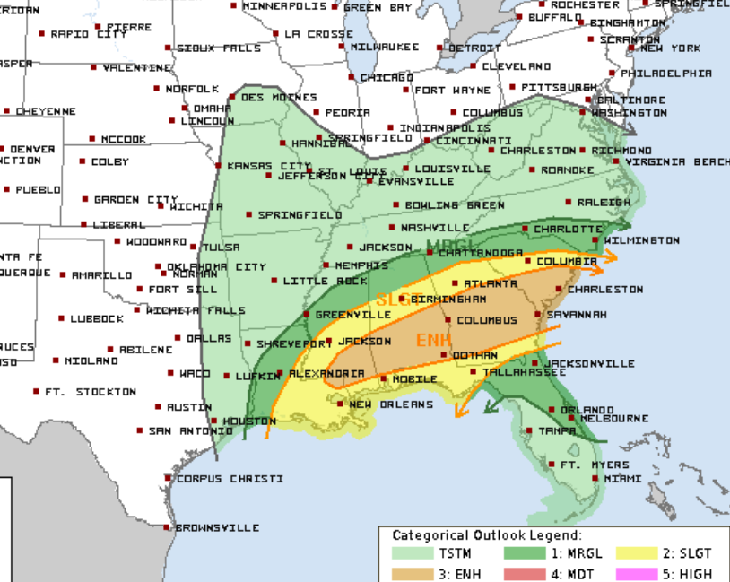
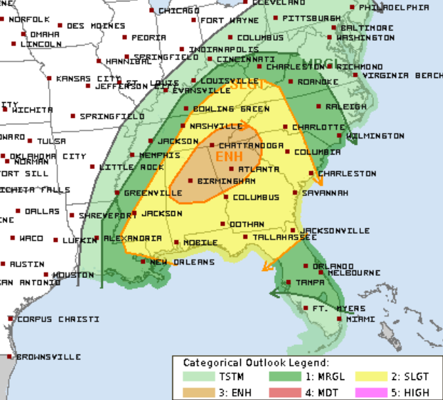
What an ominous SPC outlook this morning. Not often they mention a risk of a violent tornado
-
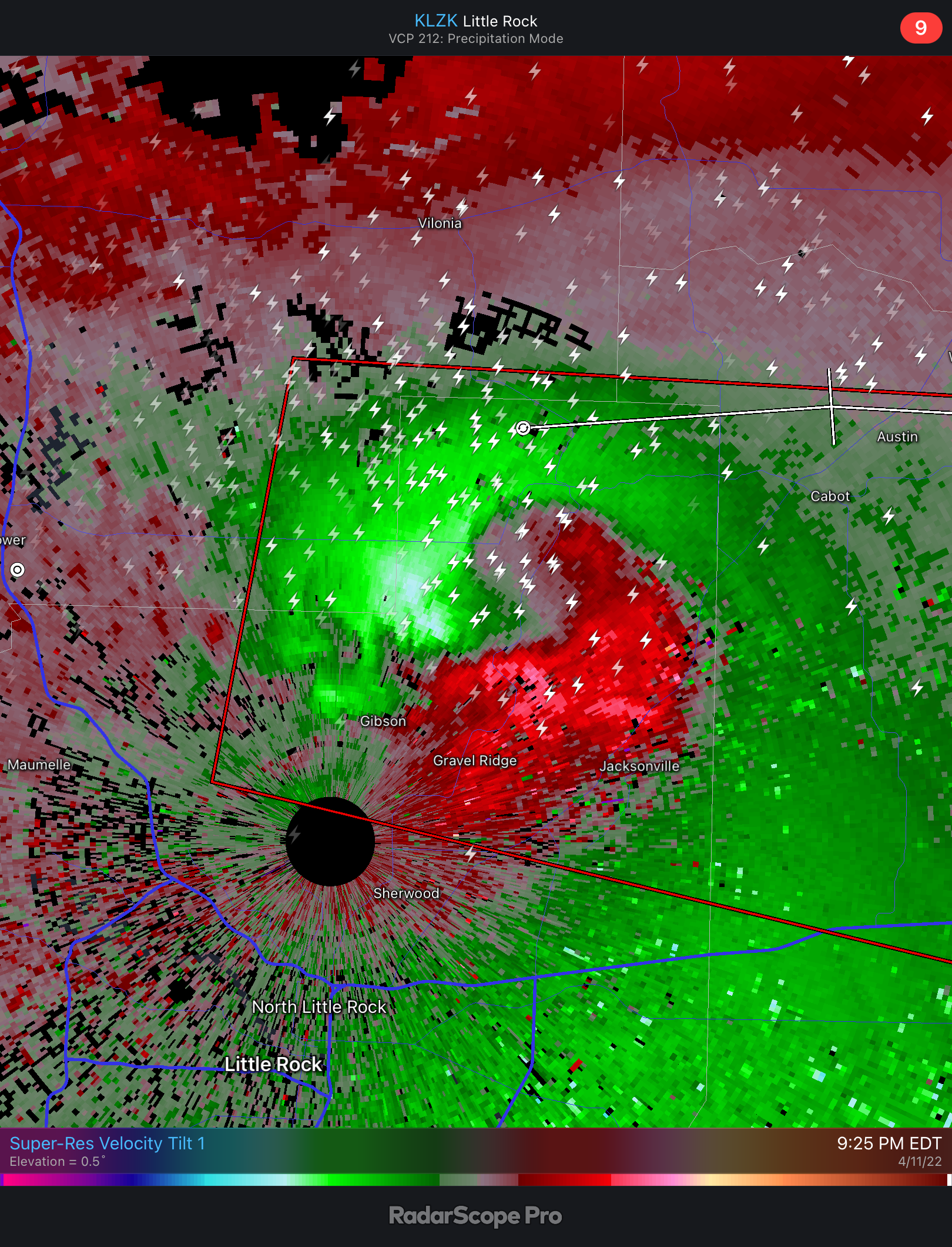
For sure is cycling
-
What a massive swirl

-
It looked like for 20-30 minutes it had a potential to put down a small tornado. Definitely a lack of wind shear and "storm crowding" affected the inflow once it got past MC
-
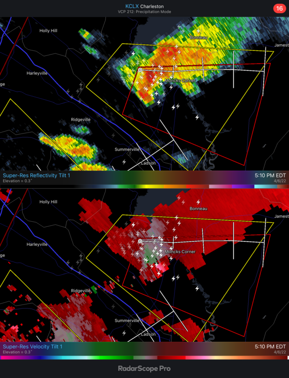
Tornado just went thru Walterboro
-
Solid lapse rates in the Lowcountry
-
Awesome video in my opinion because it shows so well what the "tightening of the couplet" looks like in real life. Rapid condensation occurring around the funnel at the LCL but a broad and general swirl in the cloud, yet intense rotation at the actual funnel itself. It's incredible how quickly the velocity of wind intensifies around a tornado, you go from a solid breeze at the inflow to insanity pretty quickly
-
Honestly the bridges would be the best place to see it
-
If 17 wasn’t such a damn mess this time of day I’d for sure drive to it. Also to the east of Moncks Corner is very sparsely populated forest
-
Damn we might get a tornado by Moncks Corner
-
Not violent, it's pretty difficult. From Mothers Day to Labor Day we really take on a fully tropical climate which lacks the wind aloft in sea breeze thunderstorms to put down anything. Also most stronger lows do not affect us as they go poleward as deepening occurs out of OK/TX in the winter and stay to the west of the Apps. It's certainly rare to see things line up, but when it does you have ample moisture to bring those LCL's down like yesterday
-
Heck of a day down here and really we lucked out. Due to the water table (whole place is a swamp) basements are not something common at all in this region. Thank God this didn't head to around Charleston, you have a metro area the size of Dayton with absolutely no basements. Really a worst case scenario for violent tornadoes
-
-
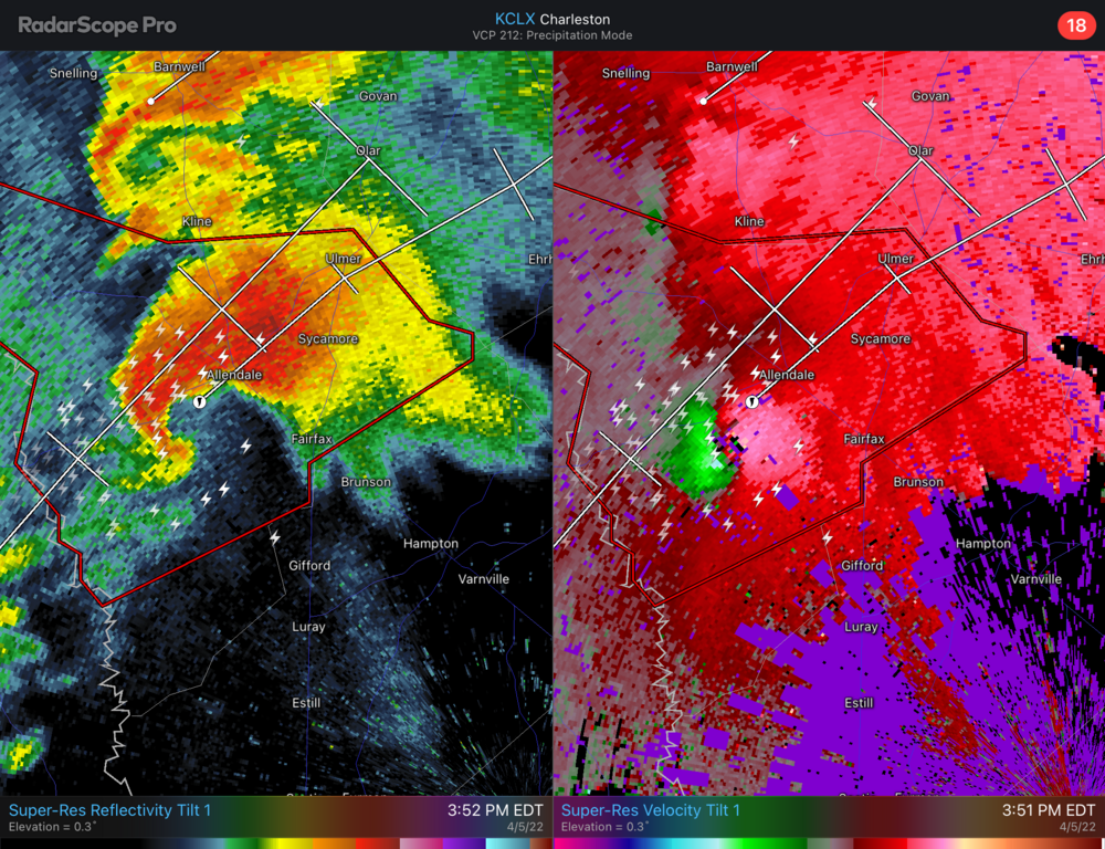
About to have a serious tornado event in the Lowcountry
-
Agreed. I think we may just need to merge or something. If the instability can build a bit this afternoon the parameters are certainly there for a strong tornado, they already are in GA
-
Really starting to bow out now. Gonna be a hell of a line racing through the South tomorrow
-
All that for a line eh?
-
Looks to be a solid two day event from Jackson to Charleston
-
Stunning day in the Lowcountry today. 77 with low humidity and a nice breeze
-
She's on the ground alright. Populated area as well
-
Yeah, as long as this current rain doesn't stabilize things too much I think there's a solid tornado chance today
-
Definitely is a MIdwest October type of threat today, however it does look like some moderate instability and ample moisture transport will be in place this afternoon for the Carolinas. I actually expect us to be under a Tornado Watch shortly
-
Might be a big one building around Fairhope crossing the bay now