-
Posts
9,404 -
Joined
-
Last visited
Content Type
Profiles
Blogs
Forums
American Weather
Media Demo
Store
Gallery
Everything posted by LongBeachSurfFreak
-
Real spring weather is amazing. Having lived in Maryland for 4 years for college I miss those endless April days of sunny and 70s with low dews. Such a rarity on the south shore of Long Island. By the time we start seeing consistent 70s in Late May/June it’s already accompanied with and sea breeze and higher dews.
-
Yes it’s higher. 1550’ for the Nordstrom tower vs 1396’ for 432 Park Ave. Both fully residential and have higher roof heights then 1 World Trade Center. While NYC no longer has the tallest buildings in the world it still has the highest residential buildings. I think part of the reason they are having trouble selling that pent house is, it’s so high it’s often in the clouds.
-
That was a really powerful nor’easter for so late in the season. Had some sleet mix in at times on the north shore of Nassua. Air show at jones beach completely canceled. Pretty much a worst case scenario for MDW.
-
Cool 150,000,000$ that’s the asking price. It’s the highest residence in the world. It’s been sitting on the market for a while though last I heard.
-
There is a pent house on top of the Nordstrom tower that has a big patio at like 1500’. That patio is the ultimate weather weenies dream. It’s so high you look over the Empire State Building. Probably get a few inches at 1500’ in this setup.
-
Southern hemisphere screamer! That’s a pretty epic model run, I think 865 is the lowest pressure I have ever seen modeled.
-
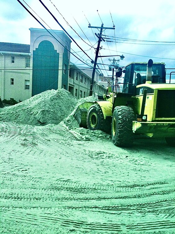
92 moved more sand then any event in my lifetime. Sandy, didn’t move sand laterally so much as pushed it inland. Pic from my first apartment at Monroe Beach after sandy.
-
This isn’t easy for me to describe in words. So bassically the prevailing flow of sand on the south shore, called the lateral drift goes from east to west. As the bluffs erode in Montauk they renurish the beaches to the west with new sand. You can actually see the sand particle size decrease as you head west. With Long Beach and Rockaway having much finer sand then the Hamptons. Under natural conditions the beaches erode and are replenished seasonally. Since humans added things like jettys to keep inlets open and groins to trap sand we have disrupted the flow of sand. Thats why there is a need for intervention. If you look at a place like west end 2 and jones beach, the large jetty protecting jones inlet acts as a block to sand movement. That area has been growing year after year. Further east at gilgo there is net erosion. So that sand that was added at gilgo ends up heading west and gets stopped by the jetty. All of this happens regardless of the local winds, seasonally. I’m sure the strong westerly winds did slow if not stop the lateral drift for a time. But any long period of easterly flow ramps it back up.
-
Could be some min/mid coastal flooding and beach erosion due to the fetch and duration. The ACOE did a major dredging of fire island inlet and dumped the sand at Gilgo where a new inlet is constantly trying to form. (There was one before it was filed for ocean parkway) Despite the fact that we have had such fast westerly flow the beach at jones beach is already about 50 yards bigger then last summer. Should grow even more this weekend.
-
Nice to see that storm track finally!! Not an especially deep so we would need strong high pressure interaction for a nor’easter.
-
Snow or not, it’s definitely going to feel alllllllllot colder this evening with peaking CAA. It’s going to be one of the nights were the temp drops rapidly then slows dramatically
-
They would be completely insane to try and play baseball with windchills in the teens. Imagine getting jammed up!
-
While that sounds like a really impressive gust, the obs just a few feet under 6,000. Mt. Washington offen gusts that high. And has gusted to 231mph.
-
I do not think that’s possible. scratch that… there were way less states in 1857
-
I mean, seasonally the jet heads north. Anytime we have a trough it would have access to that stronger jet though. Maybe I’m just looking for the silver lining in a currently shit weather pattern. I do think it’s a lock that this warm season is significantly wetter then last however.
-
Yeah. Something like that. One thing to look forward to is severe season. Which based on the prevailing pattern should be solid this year. The mid west flooding should add allot of moisture to the mix, and add the strong westerly’s we have been experiencing and it should be game on.
-
40 and drizzle is a close second to my least favorite weather, which is 33 and drizzle. Looking forward to warm sunny days ahead.
-
Yeah your right. That was off the top of my head, should have looked it up to confirm.
-
Yeah definitely worse then Sandy wind wise for the island. Likely the strongest winds in a few hundred years. Peak wind gusts in the Hamptons were 140mph and close to 100mph in Nassau (right along the water) Blue Hill in Ma, over 100 miles north east of the landfall in the Hamptons gusted to 160mph at 600 feet. (Not exactly that high)
-
Hazel went up the Appalachians and had tremendous land interaction and weakening. The reason our area experienced strong winds so far removed from the center was due to the trough. 38 was an extremely powerful and deep hurricane rocketing north. So it had very little time to weaken. The Empire State Building had a 125mph gust during 38. I read a ton of news articles about both storms and my conclusion is based off the amount of tree damage reported in Central Park. So it’s not exactly purely scientific.
-
They did not have accurate anemometers back then. The Hazel gust is highly misleading, it comes from the Battery. The wind was SE and had a funneling effect through NY harbor. Based on tree damage, the winds during Hazel were not the strongest ever in Manhattan. 1938 had significantly more tree damage, and likely higher winds.
-
-
Well there goes the rain free day. Super raw outside. Yes April often does suck here.
-
I’m starting to think that the record rains in the Midwest will have a feed back to a much wetter warm season pattern this year.
-
I’m referring to the precip in western Pa which has a different trajectory. Hopefully when it arrives it’s just a few showers.


