-
Posts
9,413 -
Joined
-
Last visited
Content Type
Profiles
Blogs
Forums
American Weather
Media Demo
Store
Gallery
Everything posted by LongBeachSurfFreak
-
Again Central Park isn’t like other parks in the city. It’s, its own entity run by the most powerful people on earth. They could care less about the NWS.
-
The exact reasons I listed above. The global elite running a corrupt organization. They treat the park like their own backyard. The large enclosure for the instruments with fencing is unsightly. So deep in the trees is exactly where they want it, and exactly where it will stay.
-
It’s very difficult to cut anything in Central Park. It’s not run by the Parks Department like other NYC Parks. It’s run by the Central Park Conservatory. They receive millions upon millions of dollars in donations from some of the richest people in the world, so it’s not a money issue. I have a good friend who I worked with at Columbia/Barnard who was a gardener at cpk and said it’s incredibly corrupt. As far as the heatwave potential. Just look at the heat waves in the Pacific Northwest and France over the last few years. Major heat domes that crushed all time records by as much as 10 degrees. The 1953 heat wave was caused by a heat dome. If that same heat wave were to happen today the highest temp would likely be 105+.
-
Yep, lots of rain recently. The issue just gets worse and worse every year as the instruments get further buried in foliage.
-
We have been due for a crappy Memorial Day weekend. Looking more likely now.
-
91,91,91,94,98,99,98,100,97,102,94,90 92,97,97,93,96,97,93,92,90,98,90 98,100,101,102,97,94,94,91,90,90 90,94,92,97,95,98,94,96,93,90 92,96,98,95,92,93,94,94,94 93,92,96,98,97,100, 102,92,104 91,93,91,91,91,94,99,101,95 93,94,91,94,92,91,93,93,91 96, 95, 95, 96, 97, 90, 92, 91 91, 92, 91, 94, 93, 94, 96, 95 98, 95, 98, 94, 95, 94, 96, 93 97, 102, 97, 96, 95, 95, 96, 95 91,91,93,95,95,100,100,94 93, 93, 91, 94, 96, 90,96 93, 93, 95, 94, 96, 99, 97 90, 93, 96, 99, 96, 100, 102 94, 93, 94, 98, 96, 93, 97 94, 95, 96, 93, 94, 94, 93 98, 100, 90, 95, 100, 97, 93 92, 97, 100, 101, 91, 90, 90 I’m just old enough to remember 93. My parents house in south wantagh had no AC except in my parents bedroom. So my sis and I would sleep on the floor in there during especially hot nights. The rest of the house was so hot it was probably dangerous. Since we were only a few blocks from the bay those nights were rare expect that summer.
-
It’s the predominant wind direction. Which has been has had less west in it the last few years. That’s why NJ has been hotter. I have a feeling we see more west wind this summer, like today and this winter. That wind direction really bakes the south shore.
-
Was, empire wind is currently on hold indefinitely. I’m not getting into politics in here but you know…
-
Flagstaff is a great spot. Super high though, like altitude sickness high.
-
The rain should make you’re allergies temporarily better as it knocks the pollen out of the air. Maybe you have some mold issues too?
-
Yeah I’m in West Hempstead at my gf place and it just got really dark. If we end up with any very heavy rain I’ll have to head home to monitor the basement. We had 7’ of water in it during the heavy rains August 23 when we had 10”. My landlord blamed my veggie garden for the flooding! So I have a channel cut through it now that drains out to the street. I graded the ground perfectly so I’m waiting to see how it handles some really heavy rain.
-
Yeah that’s what I was thinking. Norwalk is low elevation right near the coast. Norfolk the opposite.
-
20” at Norwalk seems highly sus.
-
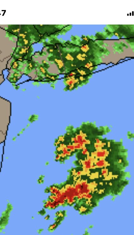
Yeah I could see the east end getting crushed again while further west gets slotted. We had that super persistent area of convection off the Jersey Shore with the last event too. Must be some sort of feedback with a Gulf Stream eddy.
-
Surprised to see a flood watch for the island. There are some discrete cells off the jersey shore, that could consolidate as they head north.
-
Perfect weather on the south shore. Deep blue sky and temps around 70.
-

2025 Atlantic Hurricane Season
LongBeachSurfFreak replied to BarryStantonGBP's topic in Tropical Headquarters
I’m super biased because I’m an east coast surfer and we get our best waves as a result of tropical activity. But I think your right. The peak of last season illustrates that perfectly. Water temps will likely support another hyperactive season, but it’s one piece of the puzzle. Let’s see where ITCZ sets up as we head into June. -
The roller coaster precipitation pattern. Either excessive rainfall or complete lack of. As the jet tends toward stagnant configurations. Fits the climate change forecasts and should only intensify.
-
I fully agree in the short term. When we cross the 2c threshold and the negative consequences become so glaringly obvious there will be across the board support for change. When sea level rises another 3 feet you start inundating extremely valuable coastal land. When summer temps are so high in the worlds bread baskets that cereal crops can no longer grow. That’s when the general populace has to wake up. When the destruction of wealth leds the charge. Capitalism is highly flawed in regards to long term greater good tendency. As we currently have the knowledge and tech to prevent most of this from happening.


