

LongBeachSurfFreak
-
Posts
9,479 -
Joined
-
Last visited
Content Type
Profiles
Blogs
Forums
American Weather
Media Demo
Store
Gallery
Everything posted by LongBeachSurfFreak
-

June 2025 discussion-obs: Summerlike
LongBeachSurfFreak replied to wdrag's topic in New York City Metro
It’s going to a complete shock to the system going from cool drizzle to a potentially historic heatwave. -
June 2025 discussion-obs: Summerlike
LongBeachSurfFreak replied to wdrag's topic in New York City Metro
95 with the incredible vegetation growth this spring. It’s as deep and dark into the foliage as it’s ever been. I would love to see JFK and LGA hit like 105 and the park is 95. -
2025 Atlantic Hurricane Season
LongBeachSurfFreak replied to BarryStantonGBP's topic in Tropical Headquarters
Gulf should spin out a few monsters this season. -
2025 Atlantic Hurricane Season
LongBeachSurfFreak replied to BarryStantonGBP's topic in Tropical Headquarters
The current water temp distribution is screaming low MDR numbers. It’s not just the cooler waters in the MDR itself it’s the warmer waters in the subtropics. This reduces vertical instability and reduces lapse rates in the MDR. This does further my prediction of a home grown season. -
June 2025 discussion-obs: Summerlike
LongBeachSurfFreak replied to wdrag's topic in New York City Metro
Wantagh being high on the list shows how anomalously hot that summer was for the south shore. That mesonet sight is in reclaimed marshland less then a mile from the open bay. -
June 2025 discussion-obs: Summerlike
LongBeachSurfFreak replied to wdrag's topic in New York City Metro
60s would have been nice, right on the ocean it struggled at 59 for most of the day. The cloud deck was so thick there was almost no noticeable warming even in the afternoon. -
June 2025 discussion-obs: Summerlike
LongBeachSurfFreak replied to wdrag's topic in New York City Metro
Raining again. Froze at the beach today. Has to be the coldest day at the beach so late in the season I have had it in 27 years of life guarding. It’s that damp east wind. -
June 2025 discussion-obs: Summerlike
LongBeachSurfFreak replied to wdrag's topic in New York City Metro
Glad I went to Pa, some morning rain but it’s been dry the rest of the day. Meanwhile a rare summer all day rain on the island. -
June 2025 discussion-obs: Summerlike
LongBeachSurfFreak replied to wdrag's topic in New York City Metro
101 is great running weather. What a joke. Long Beach has made a huge comeback to it’s early 1900s heyday. Back when Reynolds built the gorgeous houses in the red brick street neighborhoods. With wrap around sleeping porches. Very much like other coastal towns (Atlantic city) it had a ruff patch mid century. I used to live in Monroe beach and my next door neighbor was an elderly women who had lived there since the 60s. She said during the 70/80s the complex had fallen into such disrepair the pool was filled with weeds and small trees. The boardwalk was known as an open air drug market. The great thing about modern Long Beach, even though it has gentrified it isn’t prohibitively expensive like some parts of Brooklyn. There are still affordable apartments available. I’m in Pa right now but based on radar looks like the south shore is getting a real soaking right now. -
June 2025 discussion-obs: Summerlike
LongBeachSurfFreak replied to wdrag's topic in New York City Metro
Winds already 15knots SSW at the beach. Seabreeze will keep the south shore significantly cooler today. -
June 2025 discussion-obs: Summerlike
LongBeachSurfFreak replied to wdrag's topic in New York City Metro
I Left that one out because it doesn’t have a 100% mortality rate like borrer and beech leaf. But yeah it is also a problem. If we lost oaks, that would be an ecosystem destroyer. They feed tons of wild life and we do not have chestnuts as a backup. -
June 2025 discussion-obs: Summerlike
LongBeachSurfFreak replied to wdrag's topic in New York City Metro
Yeah the lantern fly craze had allot to do with PR from the wine industry as they definitely damage grapes. But overall are just a nuisance. Just raked out my veggie garden which is exploding with the warm sunny weather today. -
June 2025 discussion-obs: Summerlike
LongBeachSurfFreak replied to wdrag's topic in New York City Metro
Allot are invasives. Like Norway crap maple, black locust and tree of heaven. Doesn’t make for a productive ecosystem because our animals and insects aren’t adapted for them. And tree of heaven for example is the host of spotted lantern fly. They should all be removed where ever possible so the few native species still going strong can take over. Very dependent on location which trees. Here on the island it’s oak, hickory, red maple, tulip, sweet gum, sassafras, and black gum to name a few of the most prominent and least blight/disease prone. -
June 2025 discussion-obs: Summerlike
LongBeachSurfFreak replied to wdrag's topic in New York City Metro
Ash borer beetle and southern pine bark beetle have killed literally billions of trees in the east. Next on deck is beech leaf disease. Add that to American chestnut blight and Dutch elms disease. Eastern forests are a shell of what they once were. Acid rain and climate change are the final death blows to what’s left. -
June 2025 discussion-obs: Summerlike
LongBeachSurfFreak replied to wdrag's topic in New York City Metro
From the NOAA marine forecast. That would be a sea breeze. THUSW winds around 10 kt -
Exactly. Those years were exceptional. I hate to bring up Sandy but that event alone has a 600 year reoccurrence rate. Then a major snow storm a week later in early November, off the charts. I have a feeling this summer will be remembered for NE flooding again.
-
June 2025 discussion-obs: Summerlike
LongBeachSurfFreak replied to wdrag's topic in New York City Metro
Likely above average, 1-2 degrees. Absolutely agree about dews, lots of 88 with a dew of 75. Our climate is more resembling the coastal Carolina’s during summer. As the higher temps with lower dews combo migrates north to Montreal and Maine. -
June 2025 discussion-obs: Summerlike
LongBeachSurfFreak replied to wdrag's topic in New York City Metro
I’m ready for the switch to typical south shore warm season drought. It’s been a while since we have had such a cool wet start to the summer. -
June 2025 discussion-obs: Summerlike
LongBeachSurfFreak replied to wdrag's topic in New York City Metro
Was just going to ask the same. Had to have been close to an inch here in SW Nassua that fell in less then 30min -
Occasional Thoughts on Climate Change
LongBeachSurfFreak replied to donsutherland1's topic in Climate Change
It’s possible it’s the beginnings of. But even if it is we are likely to see a muted version in comparison to the last one. -
June 2025 discussion-obs: Summerlike
LongBeachSurfFreak replied to wdrag's topic in New York City Metro
Near zero vis on the beach right now. Hits like a wall right around merrick road. Let’s see if we can scrape together a couple tenths on the south shore. -
June 2025 discussion-obs: Summerlike
LongBeachSurfFreak replied to wdrag's topic in New York City Metro
Sea breeze just doubled in speed in about 30 min on the beach. It was remarkably calm all afternoon. Now, not so much. -
June 2025 discussion-obs: Summerlike
LongBeachSurfFreak replied to wdrag's topic in New York City Metro
Ok so an actual water temp reading from a NDBC NOAA buoy is incorrect got it. i was also in the ocean today at jones beach and it is most certainly 58 degrees. My friend was training for a triathlon and wearing a thermometer watch and it read 58. I’ll believe what I felt and what noaa records over what Lee Goldberg says from his office any day. -
June 2025 discussion-obs: Summerlike
LongBeachSurfFreak replied to wdrag's topic in New York City Metro
Ummm what? More like 58 degrees.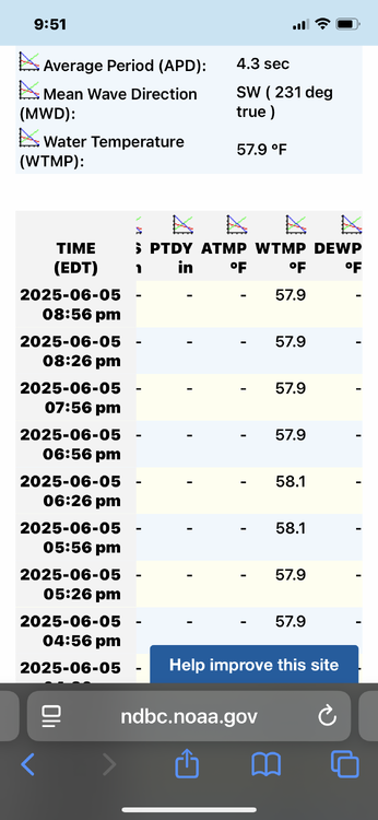
-
June 2025 discussion-obs: Summerlike
LongBeachSurfFreak replied to wdrag's topic in New York City Metro
See breeze just kicked in. It was remarkably calm earlier. The breeze has an uncomfortable chill if your in a bathing suite.


