donsutherland1
-
Posts
23,765 -
Joined
Content Type
Profiles
Blogs
Forums
American Weather
Media Demo
Store
Gallery
Everything posted by donsutherland1
-
Cool weather will continue through tomorrow. Afterward, temperatures will grow milder to end the week. The mild weather will continue through the weekend. A significant rainstorm followed by a continuation of above normal temperatures is likely Sunday evening into Monday. A general 1"-3" of rain is possible. No Arctic air appears likely through the remainder of December. If anything, the warm risks for the closing 7-10 days of the month have increased. A transition to a colder pattern could commence during the first week of January. The ENSO Region 1+2 anomaly was +1.3°C and the Region 3.4 anomaly was +1.9°C for the week centered around December 6. For the past six weeks, the ENSO Region 1+2 anomaly has averaged +1.97°C and the ENSO Region 3.4 anomaly has averaged +1.92°C. A basinwide El Niño event is ongoing. El Niño conditions will may strengthen somewhat further this month. The SOI was +6.69 today. The preliminary Arctic Oscillation (AO) was +0.180 today. Strong blocking in the final week of November, as occurred this year, has often been followed by frequent blocking in December and January. On December 11 the MJO was not available. The December 10-adjusted amplitude was 1.890 (RMM). Based on sensitivity analysis applied to the latest guidance, there is an implied 84% probability that New York City will have a warmer than normal December (1991-2020 normal). December will likely finish with a mean temperature near 41.6° (2.5° above normal).
-
I agree. I think we'll see the blocking return. I suspect we'll get something in the first half of January, but most of the snowfall will likely occur late January or February (possibly with one storm accounting for most of it). I remain reasonably confident that this will not be a replay of the 2022-23 lack of snowfall or 1997-98 in terms of snowfall.
-
There's a mixture of good, bad, and ugly news as one looks ahead into the extended forecasting range. The ugly: The last 7-10 days of December are looking decidedly on the warm side of normal. The probability that New York City could wind up with a monthly mean temperature of 42° or above has increased markedly with Atlantic blocking having broken down. Such warmth would approach the top 10 figure for the month (10th warmest: 42.6°, 1990). The bad: The largest pool of very cold air is located on the other side of the Hemisphere. It won't be available to be tapped through at least the next 10 days or longer. A jet streak will also flood the North American continent with mild Pacific air. The good: Toward the end of the forecasting range, a trough could be developing over the southern United States beneath a Hudson Bay block. The subtropical jet looks to remain active. What all this means is that a transition toward a colder pattern that could present opportunities for snowfall still appears on track for the first week of January. At least through that time, genuine Arctic blasts appear unlikely. Aside from the inherent uncertainty associated with the timeframe involved (more than two weeks), one has seen a lack of run-to-run continuity on the weekly ECMWF guidance. There has been better consistency in the idea that the first week of January should be colder than the last week of December. Both the ECMWF weekly guidance and CFSv2 are in reasonable agreement concerning the first week of January about a colder pattern than the last week of December. But abnormal warmth could still be lurking not too far away in North America. What could go wrong? Given the lack of a large pool of cold air, it is worth examining this possibility. Winter 1994-95 provides an example. On December 25-26, 1994, the MJO moved through Phase 8. A colder pattern took hold shortly thereafter and continued toward mid-January. December 30-January 12 saw a mean temperature of 32.4° in NYC with 3 highs of 32° or below and 3 lows in the teens. Despite 1.87" of precipitation during that colder period, just 0.2" of snow was measured. Boston saw 4.4"; Philadelphia had only a trace; and, Washington, DC picked up 3.9". It then turned noticeably warmer toward mid-month with the temperature peaking at 64° on January 14th in NYC. Boston had two 66° highs. Philadelphia and Washington, DC reached 70°. 1994-95 argues for a measure of caution when it comes to the duration and impact of what appears to be a more favorable pattern in early January. Until one gets closer to that period, claims about high-impact snowstorms or high-impact cold are highly speculative. For now, a more promising, but not necessarily very cold, pattern looks reasonably likely to develop during the first week of January. Details about the magnitude of cold, amount of snowfall, persistence of the pattern should it develop, etc., remain to be determined. Most winter season snowfall during El Niño winters occurs in January and February with the largest share of 6" or more daily snowfall occurring in February for NYC.
-
The statistical models can be found here: https://www.cpc.ncep.noaa.gov/products/precip/CWlink/MJO/forca.shtml
-
Cool weather will continue through Thursday. Afterward, temperatures will grow milder to end the week. The mild weather will continue through the weekend. No Arctic air appears likely through the remainder of December. However, a transition to a colder pattern could commence during the first week of January. The ENSO Region 1+2 anomaly was +1.3°C and the Region 3.4 anomaly was +1.9°C for the week centered around December 6. For the past six weeks, the ENSO Region 1+2 anomaly has averaged +1.97°C and the ENSO Region 3.4 anomaly has averaged +1.92°C. A basinwide El Niño event is ongoing. El Niño conditions will may strengthen somewhat further this month. The SOI was +6.69 today. The preliminary Arctic Oscillation (AO) was +0.180 today. Strong blocking in the final week of November, as occurred this year, has often been followed by frequent blocking in December and January. On December 10 the MJO was in Phase 6 at an amplitude of 1.890 (RMM). The December 9-adjusted amplitude was 1.862 (RMM). Based on sensitivity analysis applied to the latest guidance, there is an implied 75% probability that New York City will have a warmer than normal December (1991-2020 normal). December will likely finish with a mean temperature near 41.3° (2.2° above normal).
-
In the wake of the storm that brought heavy rain and gusty winds to the region, a period of cooler weather will settle into the region. However, temperatures could again rise to above and perhaps much above normal levels as the winter solstice approaches. No Arctic air appears likely through the remainder of December. However, a transition to a colder pattern could commence during the first week of January. The ENSO Region 1+2 anomaly was +1.3°C and the Region 3.4 anomaly was +1.9°C for the week centered around December 6. For the past six weeks, the ENSO Region 1+2 anomaly has averaged +1.97°C and the ENSO Region 3.4 anomaly has averaged +1.92°C. A basinwide El Niño event is ongoing. El Niño conditions will may strengthen somewhat further this month. The SOI was -1.87 today. The preliminary Arctic Oscillation (AO) was -0.747 today. Strong blocking in the final week of November, as occurred this year, has often been followed by frequent blocking in December and January. On December 9 the MJO was in Phase 5 at an amplitude of 1.862 (RMM). The December 8-adjusted amplitude was 1.766 (RMM). Based on sensitivity analysis applied to the latest guidance, there is an implied 74% probability that New York City will have a warmer than normal December (1991-2020 normal). December will likely finish with a mean temperature near 41.2° (2.1° above normal).
-
What was posted today is worse than his posting extreme maps. The problem in this case was that the WeatherBELL analogs had been publicly posted. One could go back to those analogs for purposes of comparison. Had the original forecast not been available, his revised map might well have stood up to scrutiny creating the perception of a better forecast than appears likely. Finally, is this a one-time issue or has it occurred before when there was no publicly-available evidence to validate the claims? In his Accuweather days, he would often "take out the trash" as he called it to discuss where things didn't work out. It seems that those days are long gone. He should delete his tweet. If so, I'd certainly be happy to delete my references to this case.
-
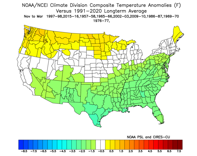
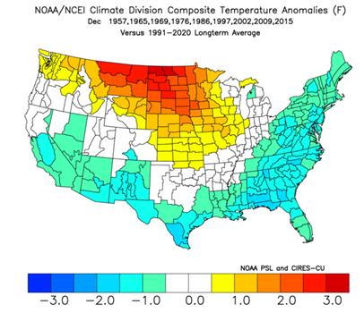
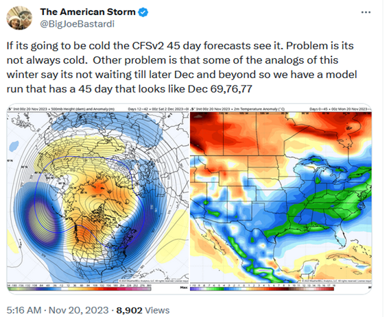
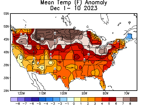
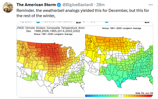
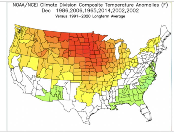
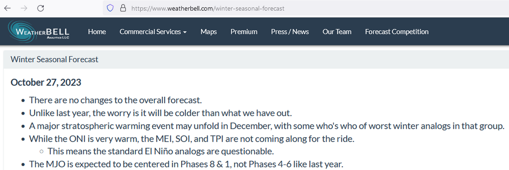
In what appears to be as classic an example of a bait-and-switch forecast to imply verification as one has seen in some time, JB has largely reshuffled his analog package to claim verification for how December is playing out in the East. This type of practice needs to be called out, as it shifts the goal posts to attempt to assert verification where verification appears unlikely (the East Coast). It is an unfair attempt to claim verification--both to the public and to other professionals in the field. Let's have a closer look: The winter forecast from WeatherBELL is posted at: https://www.weatherbell.com/winter-seasonal-forecast The list of analogs deployed is: 1957-58, 1965-66, 1969-70, 1976-77, 1986-87, 1997-98, 2002-03, 2009-10, and 2015-16 (see analog map used to construct the winter forecast) Here's how December played out using the above analog package: On November 20, when JB appeared to think that early-season cold was coming in line with his thinking, he tweeted a 45-day CFSv2 map showing extreme cold in the East (he tends to reach conclusions and then select guidance that supports those conclusions rather than using the guidance to inform his conclusions, which creates confirmation bias-related forecasting issues): The map was an extreme outlier with almost no chance of verifying in the contemporary climate. Even considering only historic climatology (not the impact of climate change), Boston had seen only 2.6% of cases with the cold shown on the map (last: 1989-90), New York City had seen 1.9% cases (last: 1917-18), and Washington, DC had seen 2.6% cases (last: 1917-18). Here's how December has played out through the first 10 days (imperiling the cold in the East idea and eliminating any prospect that the extreme CFSv2 map would verify): Rather than acknowledge that the forecast has done well in the Northern Plains but that the warmth has been more expansive than anticipated so far, including extending to the East Coast where the analog forecast was for cold, he tweeted the following on today (December 11): The full December map from that tweet is below: Look closely at the analog list shown on today's map and compare it to the forecast package posted on the WeatherBELL website. Here's how things have stayed the same or changed: 1957-58: Missing 1965-66: Retained 1969-70: Missing 1976-77: Missing 1986-87: Retained 1997-98: Missing 2002-03: Retained and used twice 2006-07: New 2009-10: Missing 2014-15: New 2015-16: Missing It's ok to revise forecasts as new evidence comes in. It's not ok to pass off new ideas as existing ones. The analogs presented on the WeatherBELL winter forecast are listed. That forecast was made public. The difference between the analogs shown in today's tweet and that forecast are apparent: 6 were deleted, 3 were retained with one being used twice, and 2 new ones were added. The December map should have been presented as a revised forecast. It is not the initial analog forecast, which was far too cold in the East. Finally, the extreme outlier map should never have been posted. 45-day maps have real limitations in skill. That the cold was exceptional relative to historic climatology was an early big "red flag" that suggested the need for extreme caution regarding the map. That the climate has warmed since the last comparable outbreaks of extreme cold further reduced the probability of the outcome shown on the map. The extreme map served no public purpose, as it was all but certain to bust from the onset. It was posted to reinforce the initial idea of a cold December in the East: 1. Notice the language in the tweet about "if it's going to be cold the CFSv2 45 day forecasts see it" (preemptive verification of a cold idea) 2. Notice the language that "some of the analogs of this winter say its (sic) not waiting till later Dec and beyond" (acknowledgement of the existence of the cold analogs that disappeared from this morning's tweet) JB should delete his tweet. It's not his best work to put it mildly.
-
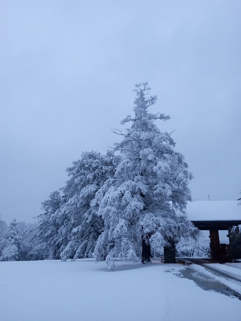
From sister in Blooming Grove, PA:

-
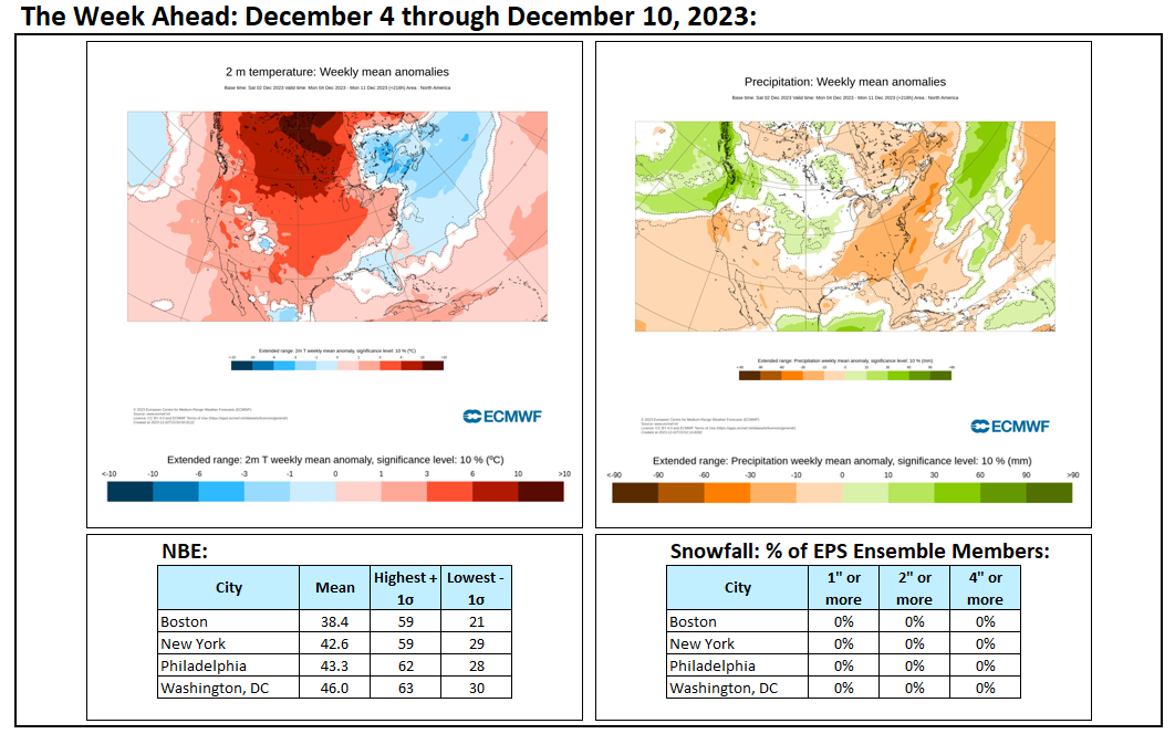
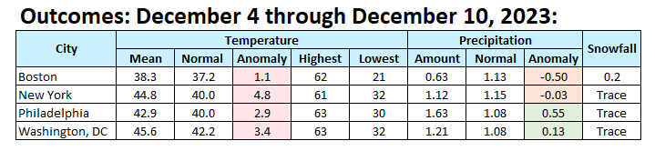
The final numbers: Warmth overperformed in New England relative to the ECMWF weekly map; parts of the Mid-Atlantic were wetter than normal.

-
You did a terrific job.
-
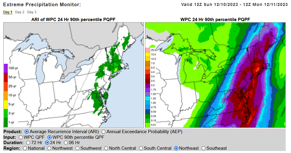
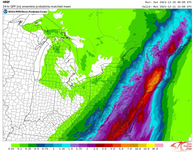
A significant rainfall is likely tonight into tomorrow. A general 1.50"-2.50" rainfall with locally higher amounts is likely in the New York City area. Parts of Connecticut could see 3.00"-5.00" of precipitation. Already, Bridgeport has seen 1.55" through 6 pm. That breaks the daily record of 0.87" from 1994 (an El Niño December). Strong southeasterly winds will gust past 40 mph. Coastal flooding and beach erosion are likely. The strong winds could bring down limbs and even some trees. Thunderstorms are possible as the cold front pushes across the region late tonight or early tomorrow. The rain will likely end as a period of wet snow or flurries north and west of New York City. New York City could see some snowflakes, as well. A cooler period will follow the storm. However, temperatures could again rise to above and perhaps much above normal levels as the winter solstice approaches. No Arctic air appears likely through the remainder of December. However, a transition to a colder pattern could commence during the first week of January. The ENSO Region 1+2 anomaly was +2.1°C and the Region 3.4 anomaly was +2.0°C for the week centered around November 29. For the past six weeks, the ENSO Region 1+2 anomaly has averaged +2.18°C and the ENSO Region 3.4 anomaly has averaged +1.87°C. A basinwide El Niño event is ongoing. El Niño conditions will likely continue to strengthen somewhat further this month. The SOI was -10.07 today. The preliminary Arctic Oscillation (AO) was -1.294 today. Strong blocking in the final week of November, as occurred this year, has often been followed by frequent blocking in December and January. On December 8 the MJO was in Phase 5 at an amplitude of 1.766 (RMM). The December 7-adjusted amplitude was 1.732 (RMM). Based on sensitivity analysis applied to the latest guidance, there is an implied 71% probability that New York City will have a warmer than normal December (1991-2020 normal). December will likely finish with a mean temperature near 41.0° (1.9° above normal).
-
A jet streak that will flood the CONUS with mild Pacific air.
-
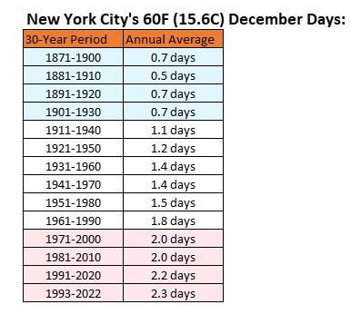
The mercury has now reached 60° in Central Park. That is the second such day this month. The frequency of December 60° has gradually but steadily increased.
-
Today, we increasingly need all the teleconnections to work together. The extent and magnitude of cold available to be tapped is less than it was 30 or more years ago. Thus, some of the earlier analogs some utilize should only be used with caution and adjustment to the contemporary context.
-
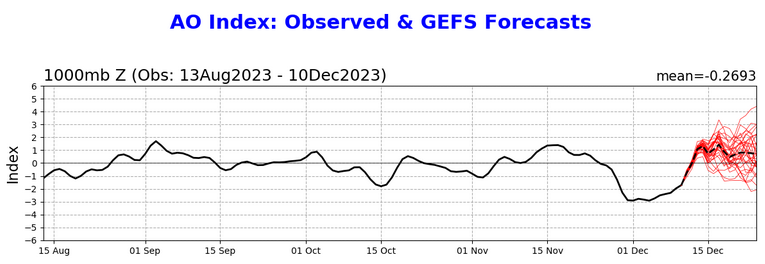
Another reason to favor the slower pattern transition (first week of January vs. last week of December): The AO is now forecast to go positive and remain positive through the remainder of the 2-week period ending December 24.
-
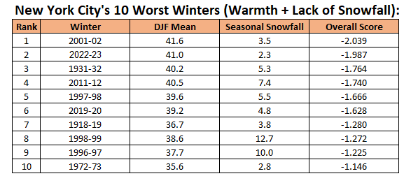
The final chart following last season for NYC's warmest and least snowy winters. The score is the combined standard deviation from the historic DJF temperature and seasonal snowfall means.
-
1997-98 is one example where Phase 8 was very warm in the East. I still don't think that Winter 2023-24 will be 1997-98 2.0. I do think that the long-range guidance has two big issues: sticks with continuity through weeks 5-6 too often or rushes pattern changes. I think this time around, we're facing the latter scenario. It increasingly appears that a transition is more likely to occur during the first week of January than last week of December. The Pacific jet streak that is forecast to develop is consistent with what has happened in past moderate or strong El Niño events and the MJO's passage through Phases 5-7 at a high amplitude. Things still working in our favor for improvement: 1. Weakening stratospheric polar vortex (favors Atlantic blocking, which has often been the case following the development of strong blocking during the last week of November--basically suggests a tendency toward what has occurred in the past). A major stratospheric warming event would be helpful for the second half of winter, but that's still a less than 50% probability. Model skill is very low beyond a week or so on these events. 2. There remains a hint that a "Greenland High" pattern could try to develop in early January. That pattern would favor troughing across the CONUS, including the East. The 12/9 ECMWF weeklies continued to show improvement for the first week of January. Potential issues: 1. The Greenland High pattern never fully develops 2. The stratospheric polar vortex begins to recover after weakening into early January (the latest forecast has pulled back somewhat on the magnitude of weakening) 3. Adverse impacts of multiple ongoing marine heatwaves (highest degree of uncertainty) The 12/9 CFSv2 weeklies have shifted to show a continuation of the warmth during the first week of January Even as there are some risks, I believe January will see some opportunities. I don't see any extreme cold shots through the end of December. I also don't buy into the "Snowmaggedon" pattern one Twitter/X account has suggested.
-
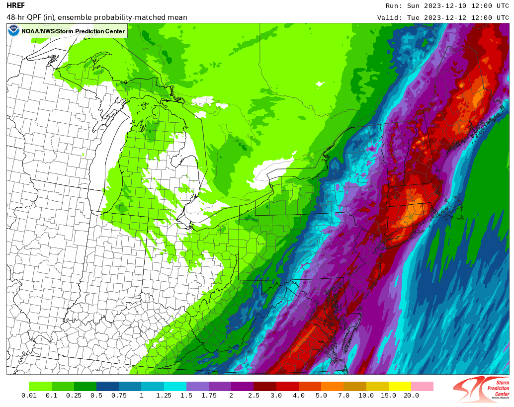
Some week ahead numbers: Note: The ECMWF ensembles are very likely exaggerating the probabilities of 1" or above and 2" or above snowfall in Washington, DC, all of which are from the storm that will impact the region today into tomorrow. The low temperature forecast for Washington, DC that is two sigma below the NBE estimate is 34°. Since 1884 when daily snowfall recordkeeping began, Washington, DC has seen only 6 measurable snow events when the December low temperature was 34° or above. The mean snowfall for such events was 0.4" and the median snowfall was 0.3". The highest such snowfall was 1.2" on December 15, 1981. There were two cases among them that followed a high temperature of 50° or above, as will occur this time around: December 24, 1911 (prior high: 52°; snowfall: 0.1") and December 16, 2019 (prior high: 57°; snowfall: 0.1"). Therefore, 0.5" or less seems far more likely than what is implied by the ECMWF ensemble members.

-
The temperature soared to 59° in New York City and Newark today. Tomorrow will likely see the temperature rise into the 60s in many parts of the region as a strengthening storm brings unseasonably warm air into the region. A significant rainfall is likely tomorrow into Monday. A general 1.50"-2.50" rainfall with locally higher amounts is likely. Strong southeasterly winds will gust past 40 mph. Coastal flooding and beach erosion are likely. The strong winds could bring down limbs and even some trees. Thunderstorms are possible as the cold front pushes across the region late tomorrow or early Monday. The rain will likely end as a period of wet snow or flurries north and west of New York City. New York City could see some snowflakes, as well. A cooler period will follow the storm. However, temperatures could again rise to above and perhaps much above normal levels as the winter solstice approaches. No Arctic air appears likely through at least the first three weeks of December and possibly the entire month. The ENSO Region 1+2 anomaly was +2.1°C and the Region 3.4 anomaly was +2.0°C for the week centered around November 29. For the past six weeks, the ENSO Region 1+2 anomaly has averaged +2.18°C and the ENSO Region 3.4 anomaly has averaged +1.87°C. A basinwide El Niño event is ongoing. El Niño conditions will likely continue to strengthen somewhat further this month. The SOI was -20.66 today. The preliminary Arctic Oscillation (AO) was -2.186 today. Strong blocking in the final week of November, as occurred this year, has often been followed by frequent blocking in December and January. On December 7 the MJO was in Phase 5 at an amplitude of 1.732 (RMM). The December 6-adjusted amplitude was 1.736 (RMM). Based on sensitivity analysis applied to the latest guidance, there is an implied 68% probability that New York City will have a warmer than normal December (1991-2020 normal). December will likely finish with a mean temperature near 40.8° (1.7° above normal).
-
Early clouds gave way to sunshine and the temperature soared to 59 degrees.